Show Posts

This section allows you to view all posts made by this member. Note that you can only see posts made in areas you currently have access to.


Messages - Bobby Shafto

Pages: < Back  1 ... 3 4 [5] 6 7 ... 58  Next >
81
Because that's the direct line of sight on a globe.

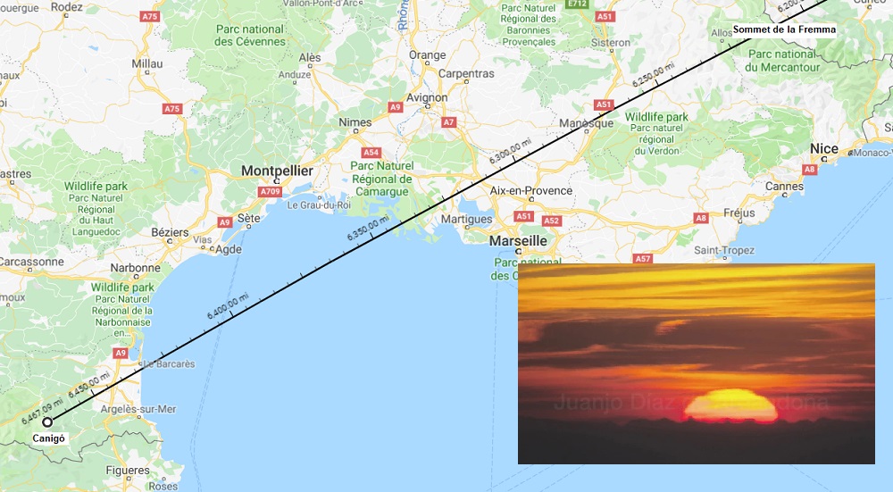
Take a globe. Stretch a string from Punta Arenas to that spot on the Tropic of Capricorn just west of Madagascar. That's the path.

One would think that the sun wouldn't rise from such a southern angle south of the sun.
One might think that if he's thinking the earth is flat. But whether you believe it is or isn't, to understand this you have to think as if the earth is a globe. Then it should make sense.

IF the earth is a globe, the sun WILL rise in southern Chile and Argentina and the Falklands from that angle even when the sun is on the Tropic of Capricorn. That's evidence of a globe.

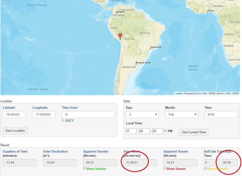
Now, the question for you is, do you believe Suncalc is right? Does the sun really rise from the ESE, contrary to what one might think?

82
If the earth is a globe, with a far away sun, which travels North-South between the Tropic of Cancer and the Tropic of Capricorn, could you help me understand why the sun would be rising up over Antarctica (or near it, depending on positioning) for an observer at the tip of Argentina today?

Feel free to play around with the measuring tool on the Google Maps website. It is accessible through by right-clicking on the map. For my replication of the angles, the path either passed over Antarctica, or was near it. I believe that explaining this point would be crucial for many of the assumptions we are making here on this topic.

I used Punta Arenas in Chile as an observer's location. I also used Suncalc to roughly find where it thinks the Sun was when it was rising from the vantage point of someone in Punta Arenas: just a hair north of the Tropic of Capricorn, west of Madigascar:


The green horizontal line is the Tropic of Capricorn. Look at how it plots on Google Maps:


Overlay those two:


Look at it depicted on a globe graphic rather than a projection of a globe:


The path between Punta Arenas and the sun location over a globe earth when it is seen rising in Punta Arenas this morning was a great circle. It's straight on a globe, and becomes warped into a curve when projected onto a flat surface. It does not cross over Antarctica.

Does that makes sense?

83
Sure. Give me a few minutes to gen up some graphics. I anticipate we'll find that the direct line of sight on a globe doesn't cross over Antarctica. Suncalc's bearing line relates to the graphic overlay and not the projection of the earth. But hang on, I'll explain better and show how it works on a globe.

In the meantime, perhaps you can take a moment yourself and clarify the answer to my earlier question and which Rushy answered for you. Is he correct about what your point is about these Web sites?

84
Are you saying Suncalc and NOAA web resources are acceptably agnostic as to their underlying earth shape model?

Or just that globe-based models aren't consistent (per you) and thus none are reliable sources of sun position data?

It's almost like Tom already told you these websites are based on predictive models and not on a singular, accurate round earth model.

Is Rushy right about what you mean, Tom?  They're based on globe earth models but they aren't consistent?


Quote from: Bobby
TimeandDate puts the location of the sun at that time at S16° 50', W71° 05'.

The NOAA Solar Calculator shows the following. See the red line below:

(Tom's image deleted from quote for display clarity. To view, see original quoted post.)

The NOAA Solar Calculator shows the sun to be directly overhead at the sun coordinates given above, which happens to be solar noon there just at the time the photograph was taken.


And here's the NOAA  bearing line overlayed with a globe-based map.


85
Are you saying Suncalc and NOAA web resources are acceptably agnostic as to their underlying earth shape model?

Or just that globe-based models aren't consistent (per you) and thus none are reliable sources of sun position data?


86
Using FET's method, where over the earth was the sun in this photograph (February 2nd, 2012 at 17:58 in South of France)
That's a fantastic question, but you're asking it nearly 7 years too late for anyone to go out and check for you.
That's an amazing answer.  Brings to mind a zetetic experiment we can perform that won't suffer from such an obstacle.

Stand by.

Disregard for now. Tom Bishop presented an excellent exercise to answer this point. If it should prove not fruitful, we can revisit the zetetic observation I was thinking about.

87
FET uses the position of the sun as evidence of the position of the sun, not a website.
Really?

Using FET's method, where over the earth was the sun in this photograph (February 2nd, 2012 at 17:58 in South of France)


88
Quote
I got the location of the sun from TimeandDate.Com

In other words, you assumed a round earth model, then created the location of the sun based on that model, and are now complaining it doesn't match a flat earth. This is circular logic. You can't make assumptions to prove your assumptions. You need to be viewing the location directly, not mathematically obtaining the location based on formulae you don't know or understand.
I didn't think I was assuming a round earth model. Like I stated above in response to Pete, I assumed everyone -- flat earther and globe earther alike -- was okay with the sun data provided by TimeandDate.

That's apparently not true. TimeandDate is based on a round earth model? It's not just pattern-based information?

I'm also not complaining about the Flat Earth Model. I'm asking for a flat earth explanation for how those points on earth can be aligned. I can do it with a globe. I can't with a flat earth. This time, I didn't say it can't be done. I said I can't do it. I'm asking you to show me how.

If the sun is depicted in the wrong place, then where should it be? What source does a flat earth model use to position the correct location of the sun?

89
I do not see any reason to object to the data, given its derivation process. You're using data for where the Sun would be if the Earth were round as per the mainstream model.
So TimeAndDate is a globe earth data source. It is not "pattern-based" as Tom has alleged?

If so, you're right. Using "data for where the Sun would be if the Earth were round" would obviously favor a round earth model.

So TimeandDate is out. So is Stellarium since that is (I assume) also data based on a globe earth model.  (Do all flat earthers agree on this or do others feel Timeanddate data is okay and agnostic about the model since data is pattern-based?)

You are also forgetting that in most FE models, optics isn't quite as straight-forward as you assume. It is not particularly surprising to me that if you assume the Round Earth model, you're going to arrive at the conclusion that the Earth is round.
I assume it because I've seen no FE model claim optics is "bendy" in the lateral direction. If I'm making incorrect assumptions, I invite you to show me how it should be, or can be, done in the FE model rather than just tell me I'm not doing it right or assuming things.

I continue not to see why this thread would belong in the upper fora. You've introduced no new information compared to your last thread, and your assumptions are exactly what they were before, and they've already been challenged. If you are not willing to adjust your arguments to persuade those who disagree, why are you here?
The information isn't new. But the information wasn't the reason why the previous topic was moved to AR. It was my refusal to respond to critics. I'm responding now to correct that. The information is worth of an upper forum discussion. Isn't it? It can be a good discussion.

90
Flat Earth Investigations / Re: Where is eye level in this photo?
« on: December 26, 2018, 05:01:07 PM »
If the earth is flat, where is eye level?
I thought I could do it using Mt Jefferson and the Middle Sister as a gauge, but produces a conflict with the more distant peaks of Mts Adam, Hood and Ranier.

But if I use one of those distant peaks, eye level is too low for the nearer peaks. 

 ???

91
Flat Earth Theory / Matching Observed Alignment of the Sun on Earth Models
« on: December 26, 2018, 04:45:32 PM »
This sunrise taken from Pic du Canigó in late May 2015 in the French Pyrenees with sun rising over the Alps 240 miles away. (Photo credit: Beyond Horizons


The sun here was overhead the earth over 6200 miles away from Canigó, at a latitude of N19° as it was transiting over the South China Sea.

I got the location of the sun from TimeandDate.Com. How TimeandDate produced that data shouldn't be relevant, as long as there's no controversy over the truth of that data. As long as no one assumes that TimeandDate is using a globe model to derive its data, is everyone -- particularly flat earth proponents -- okay with that resource, or is there another preferred source for sun locating data on a particular date and time?

If there are no objections to the sun data itself, regardless of its deriviation: the three points -- photographer in the Pyranees, peak in the Alps and sun's zenith over the South China Sea -- align using a globe model.


--------------------------

A similar photo was taken a few years earlier by that group; this one of the setting sun over the Pyrenees at a different time of year (February vice May).

This is a photo of the setting sun taken from the plateau below Montagne Sainte-Victoire in south of France, near Marseille.


Taken on February 2nd, 2012 at 17:58 local time.

TimeandDate puts the location of the sun at that time at S16° 50', W71° 05'.


According to the photograph, these points should be in alignment:
Photographer @ N43°31', E05°35' (red star above)
Pic du Canigó @ N42°31', E02°27' (blue star above)
Sun @  S16° 50', W71° 05' (sun icon above)

I can show the alignment on a globe earth:


----------------------

I have not been able to get them to align on any existing flat earth models.

I invite anyone to show me how that can be accomplished.

Or, if not, can anyone explain what incorrect assumption I might be making to expect a model of the earth to plot the alignment we can see in the photographs?

92
Suggestions & Concerns / Re: Request Review of Mod Decision
« on: December 26, 2018, 01:43:23 AM »
I understand what Tom was saying.
I didn't just say he was wrong.
I twice engaged his point explaining why it was and remains irrelevant and off topic.
He chose not to address that and persisted in pushing his off topic point.
Others (RET) were engaging him on his point.
I asked that they take it to another topic.

Was the topic moved to AR because of that conflict?

Is me asking for an irrelevant side debate be taken elsewhere "suppression?" I did not ignore Tom as Svarrior said. I just didn't want Tom diverting the topic. I know exactly what Tom is on about. It's totally incorrect to say I don't understand and refuse to address "incorrect assumptions." It's exactly the reverse. He made incorrect assumptions about my argument (as does anyone who thinks Tom was on point. I'm happy to explain yet again in the topic itself.)

Now, the issue remains. Is the appeal of the moderator's action going to be reviewed by an administrator? If that's Parsifal, I am eager to see how he interprets how that discussion topic went and if it warranted removal to Angry Ranting for my behavior.

93
Flat Earth Investigations / Re: More on "13 Miles: 60 ft NOT Hidden".
« on: December 24, 2018, 02:18:49 AM »
If you look at the video the camera and people aren't at sea level, sea level would be touching the water. It is well above the sea level as is the mirror she is not at the water either.
Please learn how to do a scientific experiment and not just some mileninal political science majors attempt at one.
Allow me to play the flat earth advocate since the folks who performed this demo do not participate on this forum and won't see your insult.

The heights at which the mirror and the camera were positioned don't need to be at 0' above the level of the water. Even if both were 5' above the water's surface (which is what I think is a reasonable estimate), the light path from the mirror should not have been detectable by the camera lens. With standard refraction, there should still have been 63-69 ft hidden behind the globe earth horizon, meaning any camera height less than that should not detect the mirror flash. With moderate levels of refraction, that hidden value drops to 44-62 ft, which is still more than a camera placed at 5' above the water surface on the far shore should be able to capture. Bump to the refraction up to  very strong levels, and that still leaves 26-43' hidden behind the curve of the earth.

A surface-level shallow-height temperature inversion could form a light-trapping duct that could possible cause the light to follow the curve of a globe earth, but there aren't the secondary visual artifacts that such a condition was present. So even in strong looming conditions, I'd still expect the camera to need to be at least around 20' high to have successfully detected that mirror reflection, even if under the most advantageous of atmospheric conditions, if we are to trust that the earth is a globe of radius 3959 miles.

94
Flat Earth Investigations / Re: More on "13 Miles: 60 ft NOT Hidden".
« on: December 23, 2018, 05:29:37 PM »
That'll be it. :)

With refraction, I get: 0.0333°, 0.0520°, and 0.0870° - same.

Cheers Bobby, that's actually really useful for something else. :)

Great. And for comparison, here is how those two geometries might compare visually:


I've tried to work this out in other views of distant landmarks before too, like my viewing of Mt Helix and Viejas from Cabrillo Point, JTolens' IR pictures of Mount Jacinto from Malibu, some views of Hawk Hill in the background of Brighton as viewed from Worthing...the vertical angles are always depressed. I didn't go looking for it here since I was just trying to experiment with using the mirror, but it works out again.

It's a little more involved than trying to assess a horizon being at eye level, and a little harder to show than images portraying "sunken ship effect," but it's the same concept.

I'm not a surveyor, of course, and these angles still have large angles of incidence meaning refraction by the air is still a factor. But so far as I've found, the analysis of vertical angles consistently favors globe topology vice flat.

But onto the next step. Next opportunity with good enough visibility, I'll be attempting to duplicate the F.R.E.E. group's mirror reflection sighting across the span from La Jolla to Encinitas (about 12 miles),  to Leucadia (about 15 miles) and to Carlsbad (20 miles).

95
Suggestions & Concerns / Re: Request Review of Mod Decision
« on: December 23, 2018, 04:39:30 PM »
Now that both plaintiff and moderator have been heard from, I request administrative review of this moderator's action. If you have any questions for me, please ask here or via PM, but I will not debate with this individual, either as a board member or in his capacity as a moderator.

96
Suggestions & Concerns / Request Review of Mod Decision
« on: December 23, 2018, 04:19:04 PM »
https://forum.tfes.org/index.php?topic=11658.msg177339#msg177339

I believe this to be abuse of moderator privileges.

1. Endorses off topic derailment of upper forum discussion
2. Done so with ad hominem

I've had issues with this moderator before. As a result, I have chosen to ignore him and not engage, particularly when he attempts to provoke me with postings that are not made in his capacity as moderator. Now he's moved a topic to Angry Ranting because I refuse to engage him.

The topic I initiated was about sun azimuth. It was being pulled off topic by misunderstanding of some participants. I asked politely that it remain on topic. Rather than help, this moderate used insult and exercised his power in reaction to his own affront to being ignored.

This was a good discussion. Not a "monologue " Violated no rules. Was on topic for the forum. If any action was justified it would have been to split the issue that Tom Bishop raised into a separate upper forum topic.

The only angry ranting in the discussion was the moderator's. I request review by an administrator.

97
Flat Earth Investigations / Re: More on "13 Miles: 60 ft NOT Hidden".
« on: December 23, 2018, 07:44:26 AM »
So we agree on the flat results, but not on the sphere. Not sure why, but I'll attach my spreadsheet so you can have a look...

Looks to me like your spreadsheet doesn't factor atmospheric refraction.  If you apply a standard adjustment of 7/6*r for the radius value, or 4619 miles instead of 3958, looks to me like you get outputs closer to mine.

If you are applying refraction already, I didn't find it; but if so I don't know why the difference then.

98
Flat Earth Theory / Re: Google Maps
« on: December 22, 2018, 06:38:30 PM »
This video clearly illustrates the matter of Soundly's observations on that lake:

Soundly posts this video to show how (some) flat earth advocates (like Ranty) misunderstand refraction.


Ranty posts a video response (Tom's post) demonstrating exactly what Soundly was illustrating.

So that we're all on the same sheet of music...

On a convex surface, refraction bending light down, in the same direction as the curvature, will make the surface appear less curved and even flat or convex if greater than curvature.

On a flat surface, refraction bending light up and away from parallel will make the surface appear curved.

We can all agree on what conditions will refract light and in what direction.

For a flat earth to appear convex due to refraction, air density must increase with elevation to cause the light to bend upward.
For a convex earth to appear flat due to refraction, air density must decrease with elevation at a higher rate than normal to cause light to bend less or not at all.

So which is it?  Just showing images of optically wiggling objects isn't analysis. Ranty hasn't refuted anything. He's just exhibited the very behavior Soundly was criticizing.


99
Flat Earth Theory / Re: Google Maps
« on: December 22, 2018, 06:18:06 PM »
Since you have provided a claim without evidence, that claim is therefore discarded without evidence. That is how truth works. Period. End of.
Can I quote you on that?

100
Flat Earth Investigations / Re: More on "13 Miles: 60 ft NOT Hidden".
« on: December 22, 2018, 09:42:16 AM »

Do these figures validate a flat plane? Or are the angles less than what they should be? I propose using the utility housing on the top of the 14-story apartment building as a gauge. It's approximately 16-17' tall at a distance of 45,820' which puts that vertical 14 pixel height at about 0.02°. The tip of the pyramid and the signal mirror reflection are both lower than should be on a flat plane.

I'll finish this tangential observation with the calculation to see if applying curvature can reconcile the discrepancy in vertical angles between those landmarks.

As illustrated in the diagram above, if the earth was flat, the vertical angle between the apartment tower and the pyramid would be 0.14°-0.09°=0.05° and the vertical angle between the pyramid and the signal flash would be 0.22°-0.14°=0.08°.

But in analyzing the photo and gauging angles by the apartment tower we can see they're not. The former angle is 0.02° and the latter 0.04°.


Solve for a curved earth and applying the curvature "drop" figures, the angles are depressed by the following amounts:


Vertical angle between Pyramid and Apartment Tower is 0.05°-0.03°=0.02°
Vertical angle between the Signal Flash and the Pyramid is 0.09°-0.05°=0.04°


Pages: < Back  1 ... 3 4 [5] 6 7 ... 58  Next >