snip (for brevity)
How can you state the graphic provided is an accurate representation of what it would look like?
You've made some valid points here. Let me see if I can address them.
Seems to me the graphic for even the globe earth is off by quite a bit.
In the graphic for the azimuthal projection it does slow down and speed up.
Seems like it was portrayed that way by the artist on purpose.
It was portrayed that way to show that, especially in the southern hemiplane, the ISS would have to speed up to cover the wider than globe distances to stay on time with the tracker as opposed to the steady, constant 17,000 mph, 90 minute orbit, on a globe. I'll get to "off by quite a bit" in a second.
I don't see why you would choose to label it as "required," if it is actually using the same mathematical inputs.
ETA: It seems you think (if the earth was flat) it needs to slow down and speed up due to matching either viewer location and the given timelines provided by the tracking website.
Yes, exactly.
Some points in response:
- The path could be transfigured incorrectly in terms of relationship between the sky and surface below. I didn't notice any perigee or apogee depicted in either gif.
Because it's basically irrelevant:
Perigee altitude 413 km (256.6 mi) AMSL
Apogee altitude 422 km (262.2 mi) AMSL
(And after looking at both gifs, I can definitely see the path over South America as rendered in both gifs do not match.)[/li][/list]
It's kinda hard to say because visually, perspectively, it's a compare of apples and oranges, or perhaps, more like an orange and pancake.

I don't believe it's intended to be exact. Just what the approximate path would be if you had to plot it from a globe to an AE map. Pretty close I would say. As well, taking the orbital path of the GEDI satellite which follows the exact orbital path as the ISS, same speed, intentionally, over a period of weeks and months, both the ISS and GEDI have many more finite arcs than depicted in the short less than a day gifs...


- If the guy (I assume McKeegan made them both) who made the gifs knows the speed is constant, then you'll need to contact him to find out why he made a false representation.
I don't know what part you are referring to that is false. It's not just McKeegan who says the ISS speed is constant, everyone does.
ETA (even further): The station must be 40° above the horizon to be visible (only at night, mind you).
Correct, at ground level.
Though it's worth noting you will only get NASA's Spot the Station alerts when the ISS is passing over with a maximum height of at least 40 degrees, this is because the ISS will be visible above most landscapes at this height. But at altitude, with a bangin' 4000MM lens I still would expect to be able to see it much, much farther away on a flat earth, but we still can't. Because for some reason it arcs below a horizon no matter how far away.
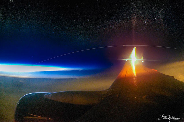
This guy does astrophotography and set up a scenario where he imaged the ISS from 39,000 feet.
 After doing some estimates and calculations on his position at the time of the pass, Mahlmann did some test shots with his GoPro HERO 4, used his sweatshirt to block out cabin light, and then captured 10 minutes of 30 second exposures when the ISS was supposed to be flying by.
Once had the frames — and while still soaring at 39,996 feet — Mahlmann took the camera’s microSD card, combined 12 of the 30 second exposures together with StarStax, and then tweaked the final result in Adobe Lightroom. Voila! A photo from a plane showing the ISS soaring by as a light trail/And not quite, dark, yes. Nighttime, not required.
The ISS is only visible because it reflects sunlight. It isn't bright enough to be seen in the middle of the day and the best time to view the ISS is either at dawn or dusk, mind you.
https://www.space.com/how-to-track-the-international-space-station