Regardless of whether the horizon is at eye level or not in all circumstances, the experiments used are not even methods that surveyors use. The people doing this experiment are basically just making up surveying science as they go along.
The tool needs to be calibrated. The experiment needs a control. Assuming that it is level or that it is an accurate method is not enough.
Well Dr. Bishop I am so glad to hear you say that. Yes. A method that surveyors use. I like the way you are thinking.
I recently purchased off of ebay a Pentax ETH-20F Digital Theodolite. I'm not talking about a silly cell phone app, I'm talking about a real surveyor's digital theodolite.
I've been learning how to use it off you tube, I calibrated it, and everything. It has a built in calibration routine. It has a resolution of 20 arcseconds.
Is that the kind of equipment you're thinking of?
I can measure all sorts of things with this, not only the dip of the horizon, but the dip of ships and mountains too! Ya?
I never mentioned too much about it because well I figured since you don't even think water seeks it's own level (even though you know how a water level works) I figured that you probably would inherently question my gizmo since you may not understand it's internal workings quite as well as you do a water level.
In any case, the experiment should be calibrated and controlled for validity.
How do you calibrate a water level, there Doc?
Just honestly curious as to how you might calibrate a water level if it wasn't reading level. Maybe add water to one end?
The device and underlying theory may be totally off in application. It's making a lot of assumptions about perspective, water tension, refraction, etc. The fact that it can't be calibrated shows the issue. We need a way to gauge how accurate it is.
Oh that's right. It's Dr. "450PPM is too much error to consider the reading valid." Even though the water level showed an internal error of less than a percent of the height of the horizon even at 100ft elevation, it can't be trusted because it's not exactly accurate to zero parts in thirty trillion.
Do you *really* think the water was an inch higher in one end as compared to the center?
This experiment has not been proven to be valid or accurate, or have any bearing on anything at all. It is not used in surveying or for any purpose. The principles need to be demonstrated.
Which experiment has not been proven valid? Oh, that water seeks it's own level? and the fact that water seeks its own level has no bearing on anything at all?
Oh, and I think it is used in primitive surveying, but someone already posted the video so I didn't.
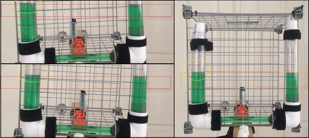
Last year a caged water device was built by a member of our forums, which showed that the alignment of the liquid in the device is susceptible to error. It was seen that the liquid did not align and that water did not find its level.

The water levels did not line up to each other in relation to the plumb line.
Hmm. Looking closely, I see that the pictures were taken at a close distance with a wide angle lens. Notice how the left tube in some of the pictures appears so much thicker?
The camera lens quite likely distorted the picture and the cage may not have been level and the camera may have been adjusted to line up with the cage.
Rowbotham has a few correct ways to determine eye level, which he describes in Earth Not a Globe
Excellent! Have you tried one of them? which one? Or which would you recommend as the best tool for measuring eye-level?
EDIT: Meant to include this one too:
Don't play the video, just look at the thumbnail: Methinks the open ended clear tubes are cut at different angles and catch the wind differently, creating pressure differences.
OK Fine play the video and hear the wind shearing turbulence across the mic. Sounds like it was a pretty constant steady wind.
The matter has already been impeached. The inability to calibrate the three chamber version of the device is direct evidence that the water is not level.