It's not teleportation. It's like an omnidirectional treadmill. My model is based on real life measurements, navigation, observations and experiences.
How do your real life measurements, navigation, observations and experiences manifest into an 'omnidirectional treadmill'?
Here is the flat earth Model that I believe in:
http://earth3dmap.com/
At any glance anyone can see this and see that this is a map of the earth corroborated by hundreds of thousands of people traveling between these locations, shipping goods between these locations. As well as by modern navigation and cartography systems. Notice when i start at America and drag the map west. I arrive back and America. Is this a different America than the one I started at? No. It's the same one. Go ahead and drag the map west 293857298375 times. Notice how the plane repeats an infinite number of times and you always arrive back at America?
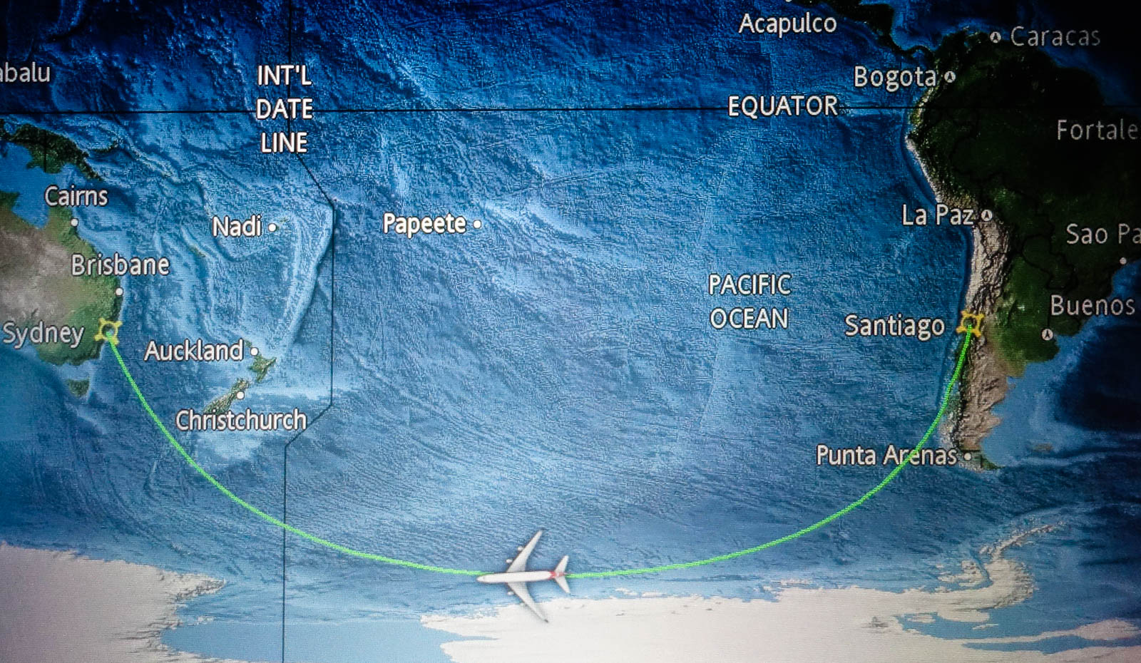
Here is an example. Measurements, navigation, observations, travel times, shipping times, and experiences do not support the flat earth model in the image on my post about flight times:
A simple internet search will show the distance between Santiago and Sydney is about 7,000 miles.
(about a 14 hour flight)
The distance between LA and Sydney is about 7,500 miles.
(about a 15 hour flight)
These rough distances and travel times have been corroborated by hundreds of thousands of people traveling between these locations, shipping goods between these locations. As well as by modern navigation and cartography systems.
This flat earth model can't possibly be correct without saying that travel times, shipping times, cartography, and navigation systems are all wrong or are all producing fake data.
You can clearly see that travel and shipping times between LA/Sydney should be MUCH LESS than the travel/shipping times between Santiago/Sydney which is a dramatic conflict between Measurements, navigation, observations, travel times, shipping times, and experiences by hundreds of thousands of people.
https://forum.tfes.org/index.php?topic=9213.0
I like what you're saying here. The AE map and variants don't work unless there's a huge quantity of people lying about all sorts of things.
The flat map of the earth from earth3dmap.com doesn't either if it were an accurate representation of a flat earth. Flights don't take straight paths on this map either. Long flights that are sufficiently north-north or south-south make huge curves. These curves take significantly longer, thus more fuel, more expense.
See the post by Bad Puppy or here's post on Eugene Kaspersky's blog talking about his flight:
ttps://eugene.kaspersky.com/2015/09/09/the-santiago-sydney-antarctic-smile-qf28/
Here's the flight path:
To add on to the map presented on earth3dmap.com, you will find the sam distance problems as in the flights between Sydney and Santiago and LA and Sydney. These will be more difficult to find as there are not many flights between Etah
Greenland and Komsomolets Island in Russia so fewer people to corroborate the distance. However, I'll give an example of how the scale doesn't work.
Etah Greenland is very closely directly north of Boston, MA. Boston, is about 42 degrees north.
Komsomolets Island is very closely directly north of Hami Xinjiang, China. Hami is about 42.5 degrees north.
Etah Greenland: 78°18′50″N 72°36′35″W
Komsomolets Island: 80°29′03″N 94°59′47″E
Boston, MA: 42°21′29″N 71°03′49″W
Hami Xinjiang, China: 42°50′19″N 93°30′15″E
We have two pairs of locations that are approximately the same distance apart on the map displayed on earth3dmap.com
Google maps gives a distance from Etah Greenland to Komsomolets Island of about 1,472 miles great circle, 2,076 miles when I manually add points to mostly follow the lattitude.
Google maps gives a distance from Boston to Hami of about 6,471 miles great circle route, 8,500 miles miles when I manually add points to mostly follow the lattitude.
The map on earth3dmap.com gives a greatly distorted map the farther north and south you go. It's just a projection of a globe onto a flat map, this does not this reflect reality.