We've all discussed here the issue of the sun being claimed to be a "spotlight"...per the Wiki.
But we know that can't be a true representation - the sun always illuminates 50% of the Earth's surface - and in that "unipolar" map - it would have to shine over a semi-circular shape in order to match what we see "in the real world".
We've also recently discussed the problem of how a "spotlight" sun can illuminate the moon and produce it's phases...and produce the phases of Venus and Mercury. (The phases of Venus were discovered by Gallileo...so this isn't exactly new news!)
But what shape does the "spotlight" have to take on the "bipolar" map?

The map on the left is the "unipolar" map - which Tom Bishop claims was superseded in 1911 when the south pole was "discovered"...the map on the right is the one that replaced it (the "bipolar" map).
Tom (and others) have said that they don't know the actual shape of the FE map...but let's just suppose the map on the right is very roughly right...
Here is the area the sun must illuminate on the equinox at noon GMT:

...a sight to give any FE'er joy! A nice circular flashlight sun on the equator and the prime meridian - lighting up both poles (just) and producing just the right sunrises and sunsets (well...assuming "magic perspective").
OK - so what does the sun illuminate 12 hours later? Well - wherever it was day is now night - and wherever it was night is now day...so the flashlight sun is illuminating...oh...this isn't good:

Er...just like a flashlight!
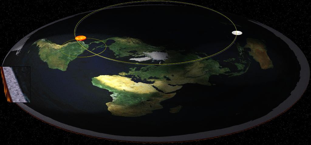
But a couple of hours before - the sun was where that red dot is - heading west to make sunsets for the west coast of the USA.
Then, suddenly it "teleports" over to the opposite side of the world (or something like that) - and a few hours later:

And it's still illuminating the "west" side of the planet a bit...
This bipolar map is just insane...there is simply no way for the sun to stay overhead the equator without teleporting - and the "flashlight" effect has to be a circular beam of darkness when it's midnight on the prime meridian.
I don't think the people who came up with the bipolar map could have thought very carefully about this!
We could - with a little effort - track the actual illuminated places on the earth by simply looking at the PVoutput.org data for any given time of day and any given day of the year - so we can plot out the approximate shape of the "spotlight" for any time we choose just by looking at which solar panel plants are generating electricity.
I'm 100% certain we can invalidate ANY bipolar map by pushing the shape of the flashlight sun's beam into pretzels.