The Earth is the evidence.
Do you deny the Earth exists?
You are nothing but a troll that goes about calling people (who you deem to be, "less than," to begin with) names, on some obscure flat earth forums, acting all high and mighty as if you are accomplishing some great mission.
I have provided an accurate picture of you for the benefit of the membership:
Still no evidence!
I use "we" to refer to the rest of the Globe's population that realises the stupity of the claims made by a few malcontents that don't have the eyes to see that the earth is a Globe.
Antarctica is real and the earth has been circumnavigated North-South by air at least times as well as some times by land and sea!The expedition including "Sir Ranulph Fiennes and Charles Burton (both UK) of the British Trans-Globe Expedition" is credited with being the first to circumnavigate both geographic poles.
First circumnavigation via both Poles, surfaceA better description is in
Transglobe expedition: Ranulph Fiennes ‘Vertical’ Circumpolar Navigation of the WorldRoute of first circumnavigation via both Poles, surface There are numerous genuine photographs of earth taken from space.In his total ignorance Totallackey thinks that:
"The images presented of the Earth as supposedly seen from space are simply artist renderings and the issue raised by your OP proves this."
They must have some pretty fast artists up there at JMC! These two images were downloaded within 15 minutes of the time the were captured by the Himawari-8 satellite.
 Himawari-8 Real-Time Image, True Colour, 21:00 UTC 01 February 2017 Himawari-8 Real-Time Image, True Colour, 21:00 UTC 01 February 2017
Downloaded 21:15 UTC 01 February 2017 | |  Himawari-8 Real-Time Image, True Colour, 21:10 UTC 01 February 2017 Himawari-8 Real-Time Image, True Colour, 21:10 UTC 01 February 2017
Downloaded 21:23 UTC 01 February 2017 |
And the only explanation you can give is that they "are simply artist renderings and the issue raised by your OP proves this."
You keep coming out with this rubbish, with only you words to back it up!
Please explain how I can get a custom image downloaded almost immediately I request it.
I can select:
various regions, including only Australia, these images are "full disk",
various combinations of sensor channels, Himawari-8 has 16 "optical" channels, the above were RGB "Truecolor" and
select times, in 10-minute intervals, over the past 24 hours, these were the most recent at the time downloaded.
Mr Totallackey, please explain how and why JMA would bother to provide such a service if it was all faked.
Still, you'd believe any fiction to prop up you imaginary flat earth!
Satellites are real and used by many countries for DBS TV, Internet coverage and satellite phones.To connect to satellite internet or satellite TV you need a satellite dish, satellite receiver, then an ordinary router, maybe with WiFi.
Something like this Regional NBN Satellite Uses
Internet access will help workers migrate to regional and remote areas of Australia.
Economic development can improve for these areas.
Tourists and Grey Nomads can gain Internet access. Social media updates promoting local areas can be made.
VOIP telephony call can be made (1/2 second latency).
Charge up devices while you are onsite. Stay longer in regional centres.
Allow for smartphone/tablet notification updates even without 3G / 4G coverage.
Download smartphone podcast (digital audio series files) updates for next leg for traveller.
eBook / Library eBook / digital newspaper / digital magazine access. Keep up to date and learn faster.
Download new emails. Send emails while onsite.
Remote tutoring / education / distant education. E.g. Online TAFE, online University, massive open online course (MOOC).
Teleworking. Access remote companies and provide digital services. E.g. Elance, Airtasker, Freelancer.
eCommerce. Sell physical and digital products worldwide. E.g. Fulfillment by Amazon (remote warehouse and sales), iStockphoto (digital media sales).
Access remote cloud computing resources such as online backup, online accounting and cloud business applications.
Remote health consultations. This could include wearable health device data reviews. Share high resolution images with specialists.
Internet of Things. River levels, water tank levels, groundwater levels, climate monitoring, soil moisture content, rainfall, wind speed.
Extend Internet access coverage with WiFi point to point wireless links.
Access online Government services.
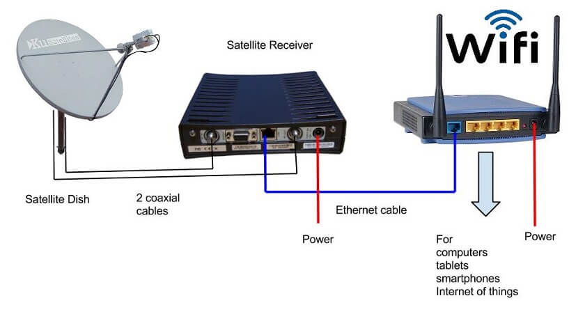
The satellite dish requires 2 coaxial cables for receiving and transmitting.
The satellite receiver has a 12 volt 20 watt maximum power supply.
A Ethernet cable (category 5) connects the satellite receiver with your Wifi Router WAN socket.
A basic Wifi Router can use a 12 volts 6 watts maximum power supply.
NBN Satellite Connection with solar power
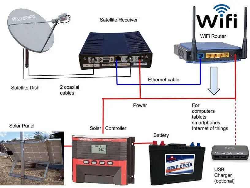
The calculations are based on a Northern Australia satellite connection with 3 days of power storage.
Solar panel is 200 watts or more.
Deep cycle batteries are 2 x 6 volt 180 Ah in series. This was chosen for weight reasons. 32 kilograms each.
The solar controller is 30 Amps with Maximum power point tracking (MPPT). This controls solar input, battery charging and power to load.
USB charging from a 12 volt source could keep tablets, smartphones and other devices charged in remote areas.
The satellite receiver and Wifi router should be kept below 40 degrees by careful design.
Much more in NBN Satellite for Australia.
Mr Totally Crappy, in Australia we have very large expanses with no phone towers no microwave dishes and in these places satellite communication is real and necessary.
So keep your silly ideas to yourself. It it interesting that many say that Muslims claims that the Qur'an teaches that the earth is flat so why then do all these Muslim countries have their own satellites?
Saudi Arabia, Pakistan, Turkey, Egypt, United Arab Emirates, Iran, Kazakhstan (70% Muslim), Azerbaijan, Qatar, Iraq and Turkmenistan (89% Muslim).There's an unlimited amount more physical evidence that the earth is a rotating globe, but I'll keep that till later!
But you never provide evidence, you just expect us to believe you, FAT CHANCE!
 Poll
Poll