These seem to the only options in a flight from Honolulu to Brisbane on this map.
What map? No one has studied the matter.
What do you mean with "No one has studied the matter"?
Aircraft flights across the Pacific Ocean are very commonplace yet "No one has studied the matter" of how these might fit with your suggested continental layouts. That seems a serious deficiency.
But you ask "What map?" Your map! The one that you have so often claimed as the official continental layout of the
Zetetic Society.
Your own Wiki gives these two and it makes little difference which you close:
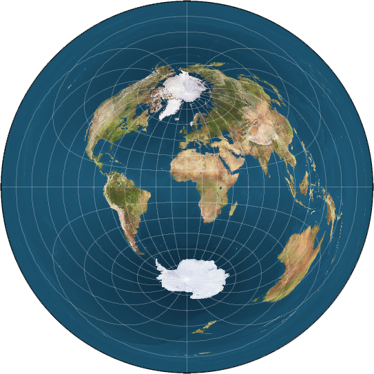 The Bi-polar Model reflects the work of many Zeteticists The Bi-polar Model reflects the work of many Zeteticists
who diverged from Rowbotham's work | |  Preferred variant of the Bi-polar map of Flat Earth Preferred variant of the Bi-polar map of Flat Earth
proponent sandokhan |
And if the earth is not a Globe there must be an "edge" where Globe is "cut" to form the flat earth representation, be it at the South Pole or in some other location.
The earth has been "circumnavigated" in virtually every direction including:
- under "person power" alone, within a few degrees of the equator,
- via both poles by sea and land and by air and
- as in the Vendée Globe races circumnavigating the earth including circling Antarctica.
You will need to study every possible continental combination, and address every possibility from jet streams to magnetic declination, to provide a valid assessment.
Why would
I "need to study every possible continental combination, and address every possibility from jet streams to magnetic declination, to provide a valid assessment"?
Then why would "magnetic declination" even be relevant? Aircraft these days use Inertial Navigation Systems integrated with the GNSS for absolute positioning.
And while they still have gyro stabilised magnetic compasses these take little part in long-distance navigation and are mainly used locally.
I have a perfectly good "map" of the earth and all of these air routes fit onto "my map" quite well - of course, it only "works" when wrapped around a Globe.