Show Posts

This section allows you to view all posts made by this member. Note that you can only see posts made in areas you currently have access to.


Messages - Storm

Pages: [1] 2 3  Next >
1

I don't know why your computer keeps having troubles with images but it doesn't matter, it's just a closeup of the image you posted. The picture works fine for me and everyone else too I'm sure, it's just an imgur link. You can also find it in the original artist post.

Remember at the start you were saying the city should be 1350 feet below the horizon and invisible, but that was not taking ~450ft of elevation into effect. The correct answer is that Dallas should be about 250 feet below the horizon, and that's just what the picture shows.

All our current guesswork says you should see between 50% and 33% of the tops of the buildings and that's what I'm seeing in the picture. We certainly are not seeing the street level, considering we only see the top of one of the more recognizable buildings.

Again, the picture is showing me exactly what we should expect to see, the top half of Dallas skyscrapers.

Nope. Wrong again.

The image I posted in reply #106 was a diagram with Object A, B and a Tangent point in the center on a curved DIAGRAM representing Earth.

It's missing right where there's a hole in my post with three lines of missing content.

What I've been saying is that the drop/curvature at 45 miles is 1,350 feet. That is correct.

What you are (not surprisingly) ignoring, and striving oh-so-desperately to get all to forget, is that there is a ridge of elevated geography in Colleyville that is ~650 feet high. With THAT present, my friend, on a CURVED EARTH, you would NOT be able to see what you are seeing in that photograph.

And, I might add, among the few curious onlookers who have followed this thread, that has been made abundantly clear.

But, I'll keep dancin with ya. Round and round we go, where this dead horse of a thread ends, nobody knows.

2
Storm, this one you're using;

https://dizzib.github.io/earth/curve-calc/?d0=45&h0=400&unit=imperial

the graphic does not change no matter what numbers you put in, or at least it doesn't for me. I think it's just a static diagram to show what the numbers are for.

Thanks, Chris.

I did notice that, but the calculator does show that almost a third of the building (280.4869 ft.) is below line of sight even without the raised area of land in between.

When you use 400 for the 'Eye height' and 45 for the 'Target Distance', then add ~200 feet to the horizon line (Stack, that's 650 Colleyville elevation [without the extra height of buildings/structures, trees, etc.] minus 450 the elevation of Dallas.), that changes the angle of sight from the observer, at h0 on the diagram, and raises it quite significantly. Making only about the top 33% of the tallest building even plausibly visible.

It's simple and I think Stack understands it.

Make a curved diagram refuting it, Stack. Be sure to stay true to the elevations and FORGET about the ridiculous sea level inflated numbers used to confuse everyone.

3
Well, interestingly, the image I loaded (two different ways - and checked the preview) has been removed and when I attempt to pull it back up using the exact URL, Google displays a blank screen with a big: 'Error 403 (Forbidden)!!1' right in the middle of the screen.

Never seen THAT in my life.

Stack, I think JSS understands what I'm doing with the elevation equations. I'm "simplifying" by making the lowest of the 3 elevations a 'zero' point of elevation so that the only relevant information can easily be dealt with and more easily comprehended by all reading.

The sea level elevation makes absolutely NO DIFFERENCE to the equation and serves only to complicate, and max out the elevation numbers, to the fullest so that the entire concept is more difficult to understand.

I continue to simplify, you continue to complicate and obfuscate.

Who's shocked?

Oldest trick in the book when hiding the Truth is the ultimate objective.

4
That doesn't even come close to what you were asked to present.

I find it interesting that there are EIGHTEEN computer-generated images used in this entire thread, some more complex than others, yet nobody will present the simple image that they've been challenged to present.

This image is the closest image in this entire thread to duplicating the dimensions in the photograph.


This image puts the observer at 'Object A' and the city of Dallas at 'Object B.'

Since Dallas' elevation is the lowest, being ~430 feet, it is the zero elevation line in this image, with the ~200 ft. middle ridge of Colleyville (Tangent Point) at ~200 feet, and the observer at ~400 feet. This image leaves out the high ~200 foot ridge of geography, that would be present at the Tangent Point; this addition would only allow the top THIRD (33%) of the tallest building in the image (915 ft.) to be visible.

As you can plainly see,...


...that is not the case.

You can even use this Curvature Calculator to prove this.

https://dizzib.github.io/earth/curve-calc/?d0=45&h0=400&unit=imperial

You claim I don't have a case?

You're right - 'cause this case is closed.

5
None of what either of you keep saying makes the slightest dent in the validity of this photograph.


If you don't want to accept the Truth, that's a personal issue, but even if the observer were at TWO THOUSAND feet elevation, this image would NOT look like this on a Round Earth. You still wouldn't see this much of the buildings due to their leaning away at forty five miles distance; and they also wouldn't appear straight up and down like that either.

All this image proves...


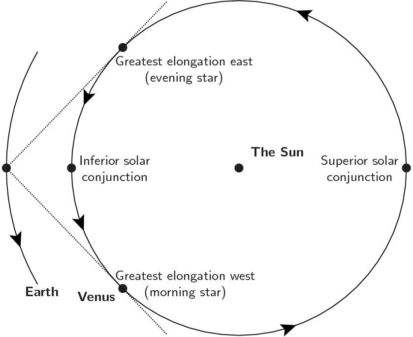
...is that Venus is very visible during the day time when THAT side of the Earth is toward the sun and Venus.

Look closely at the line that bisects the black Earth dot. That line demarcates the day/light side of Earth from the night/dark side. With that particular trajectory, shown by the dotted line, it is clear to see that Venus would only be visible just above the horizon at sundown. NOT at roughly 45 degrees, way up in the night sky, for hours after sundown.

And it doesn't matter if you want rock-solid proof of the 45 degree angle; anybody in the southern U.S. can simply look up into the sky for themselves tonight and see CLEARLY what I am claiming.

Absolutely ZERO proof needed here. They can go prove it to themselves.

So go ahead and create an image of the photograph like this one which has a flat plane surface...


...and make the ground curve, accurate to the proper dimensions in that area of Texas, and we can all put this one to rest.

Because it's Game, set, match and Checkmate when that is presented.

6
This photograph of Dallas Fort Worth...


...has not been "gone thru", it has not been dealt with and it most certainly has not been "DEBUNKED."

Not one single person in this entire thread has explained away why the majority of the city of Dallas can be seen CLEARLY from 45 miles away, from just north of Fort Worth, which is 30 miles away from Dallas; when it should be 1,350 feet below the horizon.

Nobody has argued that math.

These are facts.

There is no more proof NEEDED, and there is no satisfactory proof that can be presented online to convince those who refuse to accept what their eyes plainly see.

The computer generated images from Stack of this...


...are absolutely worthless, and have zero basis in reality. Especially the last one.

JSS demands photos of all my observations over time, as well as further evidence, while JSS provides nothing concrete and expects this 'computer generated' image to serve as undebatable evidence of Venus' dynamics in relation to Earth.


Tumeni refuses to create an image, very similar to this one...


..., of the photograph in question, but on a curved plane -- which would prove the entire position of the OP and lay this entire thread to rest.

So, all that is going on here is people talking in circles.

The photograph that started this entire thread is YET to be explained, from a round earth perspective, simply because it cannot be explained away.

Once again, in a court of law, the ONLY piece of evidence that would hold up to legal scrutiny is the photograph that this thread is based upon.

Nothing else that has been presented to the contrary holds one single drop of water.

7

Could you please show me your examples of where the "curvature formula" does not work?

Thanks.

Oh, if you insist...


...it does a smash-up job of working here.

The city to the left of the image is 45 miles from the observer. Should be 1,350 feet below the horizon based on Rowbotham's curvature formula that he took directly from the scientific-stated (claimed) circumference of the Earth.

I'd ... say it's not workin there too well.

I'm not sure what you mean by 45 degrees. ... and it will change nightly.

Well, it means when somebody in the southern U.S. is perpendicular to the flat ground, the very bright star Venus is at a 45 degree angle from their person. If they look straight up at a 90 degree angle, the star is at 45 degrees.

And, no, it doesn't change each night. Not in any perceptible way. It's been at the same angle (roughly) for months now; every single night after dark. Brightest star in the sky; hard to miss.

Many of the explanations would only make sense if it were way down right on top of the horizon line at sundown. Anybody observing it will confirm that is not the case.

And it remains visible in the night sky for 3-4 hours after sundown.

The only way that is possible is for Venus to be somewhere on the opposite side of the Earth from the sun; it would need to have an orbit outside the Earth's orbit; meaning a further orbit from the sun than the Earth.

And, regardless of that particular detail, the FACT that it has been visible so high in the night sky, at roughly the SAME ANGLE, for months now, demands that it be in some sort of sync with the Earth. Which has already been proven to be impossible per their widely differing orbit speeds and orbit circumferences.

8


I'd like to issue you a challenge.

Fire up your CAD diagram machine and create a diagram of your ROUND EARTH depiction of that photo, from the observer to the target city--using ACCURATE dimensions, showing ACCURATE curvature/drop for that distance (1350 feet), with the observer on the left and the target on the right - just like you've been showing with a FLAT ground line and make this one with a ROUND ground line. Wow us with your results.

Don't have CAD, but ... why should I? ...

Exactly. Why should you make it THAT obvious that you're completely wrong.

The fact is ... you can't. Plain and simple.

If you were to post the diagram that you've been challenged to create, everyone who saw it would see immediately that the very photograph this thread is all about 100% proves the Flat Earth.

Quote from: JSS
The formula for estimating the curvature of the Earth you are trying to remember is "Eight Inches Per Mile Squared" that is also used in the 1800's FE bible by Samuel Rowbotham so is used almost exclusively instead of the correct math by most of the Flat Earth community.

The problem is this is wrong.  That 8 inches per mile squared function plots a parabola, not a circle. It's obvious when you note that the FE formula doesn't include PI, which is essential for calculating anything involving circles.

It gives close results for some distances but with very large values it becomes completely inaccurate. It's used a lot in back of the envelope engineering calculations because it's good enough for a few miles and works well as a rough estimate for more, bu eventually it stops becoming useful.

See the image below for how that formula works.  It fits pretty well for a while, but then starts to go wrong and gets worse very fast.

None of this makes any difference at all. It's all completely irrelevant because NEITHER formula works one single bit on the Earth that we all live on.

Not once has either curvature formula ever been proven to reflect the reality of the physical plane that we all inhabit.

Furthermore:

Though there were a handful of responses, not one person has tried to explain why Venus can be seen every single night in a row, for going on THREE MONTHS now, at 45 degrees in the sky after dark.

Not ONE diagram or explanation has even come close to explaining this tom-foolery.

Now, somebody will try to claim that Earth and Venus are completely in-sync with each other despite the fact that I've already posted their 'far-from-close' orbit speeds and orbit circumference distances.

So, ....... what's the explanation?

9

Mercury can be visible about an hour before sunrise and an hour after sunset, and Venus visible much longer before sunrise and after sunset.  Try looking at a scale diagram of the orbits of the inner planets and draw some lines from the orbit of Venus and see just where it can intersect Earth.

Sure, the list goes on and on with all sorts of stuff flat Earthers don't understand.

No.

I'm sorry.

That just doesn't cut it.


Venus moves at 78,341 mph on its orbit around the sun, while Earth moves 67,000 mph. Venus' orbit is only 67 million miles around the sun, while Earth's orbit is 92.96 million.

https://earthsky.org/astronomy-essentials/visible-planets-tonight-mars-jupiter-venus-saturn-mercury

Yet, in the southern U.S., Venus is visible at 45 degrees -- WAY up in the night sky, after sundown for at least two months STRAIGHT. Tonight, Venus is visible for as long FOUR HOURS after sunset. That means I can see it til ONE O'CLOCK in the morning.

How is this possible when the Earth is turned AWAY FROM THE SUN COMPLETELY at night time??

There's not a CAD-diagram spell you can CAST that'll explain THAT one away.


Now, come with all your Ad Hominem attacks on my person, since you can't attack my arguments and let's all have it.

10
Your task is to answer WHY they're not hidden from view. Remember?!

.. but they are (hidden from view)

The photographer explicitly states that we can only see the ball of the Reunion Tower, which stands 991 feet above (I presume) MSL.

The photographer is presumed to be at 800 - 850

Something is obscuring some 950 feet of the Reunion Tower, and the ground below it. How can it be the 650 feet of intervening ground? How did that grow so much it can intrude on the upward sightline from 800 to 991?

You are way off. The Reunion Tower is only 561 feet tall.

https://en.wikipedia.org/wiki/Reunion_Tower

Now, look at it this way:
Observer = ~800-850 ft
Colleyville terrain obstruction = ~600-650 ft
Dallas = ~450 ft

If you consider the elevation of Dallas, ~450 feet, as simply 0 feet, then consider the point of the observer to be ~400 feet above that and the elevation in between, the Colleyville area, to be ~200 feet above that zero point of elevation, then the photo looks "EXACTLY" as it should look.

Isn't that interesting?

You are purposely ignoring the roughly 100 feet of trees and buidlings above the elevation of the Colleyville 600-650 foot elevation. And the ball of the Reunion Tower is roughly 100 feet, top to bottom. So, it's actually exactly as it should be.

And for those who keep saying the observer should be looking UP, that is just a bunch more nonsense. You are looking at a city that is FORTY FIVE MILES AWAY! The tallest building is 915 feet, not nine THOUSAND feet.

The horizon is at eye-level. That is where the buildings are.

Now, since you are STILL deflecting from the obvious, here, I'd like to issue you a challenge.

Fire up your CAD diagram machine and create a diagram of your ROUND EARTH depiction of that photo, from the observer to the target city--using ACCURATE dimensions, showing ACCURATE curvature/drop for that distance (1350 feet), with the observer on the left and the target on the right - just like you've been showing with a FLAT ground line and make this one with a ROUND ground line. Wow us with your results.

Show us all how it's possible to see that city if the Earth is a ball.

11
Why should my diagram "account for" curvature when it is explicitly based on a presumption of a flat plane?

Right. I mean Why address the gigantic hole in your argument--the missing curve?


We don't need you to explain WHY we can see the buildings perfectly on a Flat Plane. We know WHY we can see them--because it's a Flat Plane!

Your task is to answer WHY they're not hidden from view. Remember?!

12
This, here, is absolute NONSENSE.


This is exactly the kind of computer generated fantasy abstract cartoon foolery that'd get laughed out of a court of law.

Without the magical math theorems and computer-aided Disney nonsense, there doesn't seem to be any other way to refute the Plane TRUTH of the Flat Earth we ALL inhabit.

BUSTED!!


I feel like I'm debating one of these:


13
This is hilarious.


Doesn't account for the 1,350 foot drop in curvature of the target building AT ALL.

I guess you hoped everyone would forget that part.

14
And it is YOUR maths which predicts 1,350feet. Maths you have done incorrectly as I have explained - not for the first time in this thread.

Let's check.

Distance squared, multiplied by 8 (inches of curve per mile), divided by 12 (to render feet).

45 miles (45x45)
8 inches per mile (multiplied by 8 )
12 inches in a foot (divided by 12)

What do you come up with?

Maybe it's your calculator. Or maybe you don't understand Round Earth MYTHOLOGY well enough to properly PROVE it.

(Hint: It's really hard to prove something that has no inherent TRUTH.)

Who's floundering?

15
Your problem is you don't understand the globe earth heliocentric model well enough to debunk it.

While we're offering each other constructive criticism,
You don't understand it well enough to prove it.


I'm impressed you used the correct word, there, in reference to Round Earth.

Definition of debunk
transitive verb

: to expose the sham (see SHAM entry 1 sense 2) or falseness of
debunk a legend

https://www.merriam-webster.com/dictionary/debunk

16
Sure, the list goes on and on with all sorts of stuff flat Earthers don't understand.

Hmmm....wow. You're right.

So, let's recap what Flat Earthers don't understand.

Here's your proof of round earth.


And, let's see, you said "The furthest observer distance in that video is 30 miles.", right?

Ok, so that means the far right building, being 190 meters/623.6 feet tall, will disappear approximately 2/3 of its height, or 415 feet, from view at that distance (30 miles). With no obstructions, no geography in the way, viewer at roughly sea level, blah, blah, blah.

BUT,....on the same world, there's this........


With the buildings in the city (Dallas, Tx.) to the far left in the image being '45' miles from the observer. Those buildings having no greater height than 915 ft., the tallest.

Now:
-the photo was taken at a height of roughly 800-850 ft elevation;
-the elevation of the city in question being roughly 430 ft;
-and a rise in geography between the two at roughly 650 ft in the area of Colleyville. (see Topo map)

At 45 miles, there 'should' be a drop/curvature of 1,350 feet, on a PERFECT SPHERE.

So, tell me, and all the other poor Flat Earthers who just can't seem to grasp the complicated math and divine science, just HOW it's possible to see the ENTIRETY of those buildings.

The only portion of those buildings that is out of view is the bottom approximate 200 feet, which is explained by the ridge of geography in the Colleyville area on the Topo Map.

Here's the Topo Map to prove all those elevations.

https://en-us.topographic-map.com/maps/nct/Fort-Worth/

Do you really expect everyone to believe that the ~400 ft. difference in elevation between Dallas and the observer accounts for the plain visibility of that entire downtown city skyline when your own maths and CAD diagrams, etc. confirm that there 'should' be a THIRTEEN HUNDRED AND FIFTY foot drop in curvature at that distance?

17
I'm not having a go but come on, dude, this really was simple maths. I've probably over-complicated things, Tumeni's explanation was simpler and better. The fact that it had to be explained to you shows that you really don't understand stuff as well as you think you do. I note that you are now floundering around saying "Aha, but the experts say it's not a perfect sphere!". Well you're right.

Floundering? Please.

More evidence has been presented in support of Flat Earth than anything Round Earthers have EVER dreamed up.

--Polaris (North Star) never, ever, moving from its place in our sky.
--All the constellations staying exactly the same throughout all of recorded history despite the four 'alleged' and unfathomable movements of the Earth through space.
--The '50 mile long' Panama canal that is officially 'perfectly level' from end to end.
--The Bedford Level experiments.
--Countless photos and videos of horizons many miles long with zero curve.
--Crepuscular Rays indicating the close proximity and small size of the sun-disproving much of the myths about space and our solar system, etc.
--Mercury and Venus being visible in our night sky when they're 'supposedly' closer to the sun than Earth making it impossible for them to be seen when the Earth is turned 'AWAY' from the sun (i.e. night time).

The list goes on and on. No need to have any expertise in all the silly mathematical equations and formulas for proving empirical things wrong using metaphysical concepts.

And, just like Tumeni's response, here,......

Simple geometry, simple maths. Using textbook figures, equatorial circumference is 24,901 miles, polar 24,860.

The distance of an arc of one degree is therefore between 69.17 miles and 69.05  (24901/360 and 24860/360)

The building exactly 69 miles away leans by one degree, when rounded to the nearest degree.

To a few decimal places, it's between 0.99754 and 0.99928 degrees.

Not enough difference for even the keenest-eyed human to make out a building "leaning away from them" ....

......it is ALWAYS the same answer: "It's round, it's curved, but you will NEVER see it, nor find ANY irrefutable proof of it, no matter what."

Round Earth's arguments and rebuttals are textbook and utterly predictable.

Again, I present Nikola Tesla's quote referring to Einstein's Theory of Relativity due to its profound relevance.

"Einstein's Relativity Work is a magnificent mathematical garb which fascinates, dazzles and makes people blind to the underlying errors. The theory is like a beggar clothed in purple whom ignorant people take for a king...its exponents are brilliant men but they're metaphysicists rather than scientists."
-Nikola Tesla

Metaphysics - Abstract theory with no basis in reality

18
Ok, AllAroundtheWorld or Model 29 or Tumeni or iamcpc or whatever your user name is TODAY,

excuse my ignorance and my lacking research, since you caught me,

BUT it seems to me that you keep using these maths and geometric formulas for a PERFECT SPHERE.

And, hmmm, I'm pretty sure that your Lord DeGrasse Tyson, and all the other cronies, have admitted repeatedly that the Earth is NOT a Perfect Sphere.


SO,......yeah,.......that'd make your simple maths, there, completely faulty.

Seeing that you have NO idea what portion of the Earth is more elongated, or more curved for that matter, it's sufficient to say that you CANNOT use that formula at all.

If the Earth is more oblate around the equator, (which doesn't match up with heat patterns there due to Earth's tilt and lack of alignment with the sun) then that means North to South might be 'flatter' in some areas, but not in others, and that it'd be more curved East to West in some areas, but not in others.


Again, Round Earthers can't provide any plausible proof of any of their rebuttal arguments. Just more abstract theory, garbed formulas, faulty maths and faulty logic.

Bottom line:

Round Earth wouldn't just lose in a court of law, it'd get laughed out of the court room before a trial could even ensue, due to a complete lack of supporting evidence.

Face it: You have NO case.

19
Flat Earth Theory / Re: I think you're wrong. Discuss if you dare
« on: March 07, 2020, 08:40:14 PM »
Hey Tom,

Here's that image you PM'd me about.

And, I totally agree.

Answers a lot.


20

Quote
I cannot explain a video/photo that somebody else has made.

Why not? You're expecting us to do that with the photos you present.

Quote
I present simple PHOTOGRAPHS. Not elaborate video constructions that have obviously been created using video editing software.

Quote
BUT I will say, in my personal opinion, that it is very likely doctored (photo-chopped) because the building does not 'ever' appear to lean away from the viewer. Take a close look at the top of the building in each image. It is identical. Same height, same angle. Zero evidence of the building leaning away whatsoever. As it quite plainly should be were it sinking down around the other side of the "Frontal Curve" of the so-called round earth globe.

Once again you are failing to understand the scale of the earth. The earth is 24,900m in circumference. The furthest observer distance in that video is 30 miles. Simple maths will tell you that the angle the building is leaning away from you at that distance is less than half a degree. You would not be able to perceive that. FE people do often seem to struggle to understand the sheer size of the earth, when you understand how big it is it helps you understand what you "should" see in certain situations.

Oh, less than half a degree? Really?

I'd love to see these simple maths you boast of. Please, enlighten us.

Because the distant city in the original post pic is 45 miles away from the camera. Let's just see how many fractions of a degree those buildings are SUPPOSED to be leaning away. We'll be waiting patiently for your presentation.

Since you've never 'seen' the Earth from space with your own naked eyes, I'm curious how it is you've convinced yourself that YOU have grasped the "sheer size of it" so much better than the common laymen who starve below your grandeur.

Pages: [1] 2 3  Next >