Show Posts

This section allows you to view all posts made by this member. Note that you can only see posts made in areas you currently have access to.


Topics - Bobby Shafto

Pages: [1] 2 3  Next >
1
Flat Earth Investigations / Neumayer Station III
« on: January 12, 2019, 05:40:06 AM »
There's a 24-hour webcam posting previous 24 hour shots at 10-minute intervals, located on the Ekström ice shelf, drifting but currently at  S70°38′42″, W8°15′51″.

https://www.awi.de/en/expedition/stations/neumayer-station-iii.html

According to Stellarium, that location will not experience a sunset until January 25th. The camera is static so you can't watch the sun move around 360 degrees, but you could check it daily to see if it enters twilight. 


January 12th

2
Flat Earth Theory / The Sagitta (Globe Earth "Theory")
« on: January 10, 2019, 06:41:09 PM »
Sagitta is the fancy term for what is commonly referred to in flat vs. globe discussions as "the bulge."


I've always been a bit annoyed by references to "the bulge" in talking about "globe earth theory;" and not because of the term itself but because I don't think the measure of the arc above the chord is germane. The bulge is not a mound or hill that rises up in front of you on a globe and presenting an obstacle. The bulge is not the obstacle. The horizon is.

The only time that the bulge matters is when the horizon happens to coincide with it, as I've depicted with the diagram (from Metabunk's interactive visualizer) above. The horizon is a function of height above the arc. The bulge is a function of base locations on the arc. For any two points on the arc of a globe, the obstructing horizon varies with height but the bulge is fixed.  Only at a height where the horizon corresponds to the midpoint on the arc between two points does the bulge matter, and then only because it's where the horizon is.

The "bulge" isn't a mound rising before your eyes. On a globe, the arcing surface drops away from your eye level. If I had my druthers, we'd banish "the bulge" from any discussion about how things work on a globe. It's often misconstrued and misrepresented as that which causes or would cause an obstruction to line of sight compared to a flat earth; but that's in error.

Consider two points on earth that are 30 miles apart.
On a flat surface, they're just that: 30 miles apart.
On a globe with a radius of 3959 miles, they are 30 miles apart on an arc of 0.43°. The height of that arc above a straight line (chord) between those two points -- that height being the bulge or sagitta -- is 0.0284 miles or 150 feet.  Over the span of 158,400' between the two points on the arc, how significant is that 150' sagitta?

That additional 150' of the sagitta (bulge) contributes some amount of additional distance on the arc of a globe compared to the straight line chord length which would be the flat earth distance. Guess how much extra distance? Or, if you know how to do the math, work it out.

I'll be back.

Edit: Come on, my fellow globelings. This question is for anyone, and I'm sure globe supporters can come up with the solution. There's probably even an online calculator that can provide the number.

But until then, just guess. Anyone? What do you think the difference is between arc length and chord length in the 30-mile distance scenario above that a 150' "bulge" would produce? Just ballpark it.


3
Flat Earth Media / JTolens New IR Video
« on: January 07, 2019, 07:59:54 PM »
JTolens has a new video up with some more stunning near IR imagery:


(click to expand)

I disagree with his analysis of the photo, his use of an out-of calibration theodolite to draw conclusions, and his explanation of "upwards" refraction to explain dip of the horizon and the appearance of curvature. But I'll leave that discussion on another forum topic.

In the meantime, worth a look.


4
Flat Earth Investigations / Project: 180 Degree Horizon Through Pipe
« on: December 31, 2018, 07:16:39 PM »
A flat earth YouTuber made this challenge.

Set a narrow pipe up level on a hill or mountain that has views to an ocean horizon 180° apart. Sight the horizon centered through the tube from one end, then go around to the other end and see if the horizon is centered in that view.

I don't have a vantage point that fits the bill, exactly. I can gain a vantage point on Cabrillo Point that is ~400' elevation with no land fall along a southerly line of sight all the way to Antarctica. But 180° away from that direction, I only get 50-some miles before the line of sight crosses inland at San Onofre and then the Santa Ana mountain range beyond at around 70 miles.


Here's the question: on a globe, from 400' the visual horizon should be around 25-30 miles, well before landfall at San Onofre. That doesn't mean one can't see land rising up beyond that on a  globe horizon if it is high enough.  I know from experience that I can see the Santa Ana range, including ~5700 Santiago Peak, from that spot if the air is clear.  Clear enough, and with recent snows, I'm sure I could even see 10,000+ ft Mt San Antonio in the San Gabriel mountains, over 100 miles away.

But if I try to perform this pipe experiment, will that backdrop of mountains confuse the issue?

What if I were to do it this way? Mount the pipe on a 48" carpenter's level, set upon a tripod, get it level and then make the first sighting to the south.
On a globe, I'd expect the horizon to be below center. On a flat earth, the horizon should be centered.
Say the horizon is below center. That may not mean "globe." It may just mean I didn't get the level right. So, then adjust the level until the southerly horizon IS centered.
Then, go around and sight to the north.  Centered in the pipe should be eye level line of sight for a flat earth.

Is there anything wrong with that reasoning?


5


This is a frame grape from a video I took Sunday from Mt Soledad in La Jolla looking south across Point Loma toward the Mexican Coronado Islands, about 30 miles away. That's South Coronado Island. It had been super clear on Saturday, but Sunday the haze had returned, so I hope to get back to this same spot soon on a day when there is a sharp horizon of blue sky against the sea. 

My hope is that this vista will provide evidence of either flatness or convexity. If flat, the horizon should, on clear days, appear near the level of the South Coronado Island summit.  Thing is, I don't know for sure what that elevation is.  Google Earth seems to believe it's 580', but other sources indicate it's over 700' high.

I can also make out the Old Point Loma Lighthouse. Google Earth puts the tip of the cupola at around 465-467', which seems right.

My viewing elevation, with tripod height, was about 770 ft. If I bring out eye-leveling tools, where will eye level be? Will that S. Coronado island summit be near eye level?

Anyone care to join me in analyzing and researching these identifiable points before I'm afforded a clear day on which I can get back there to shoot the horizon with my level tools?  I think I'd like to compose a video of the analysis and the process of collecting the data, which I'll post whether it suggests -- I avoid saying "prove" -- a flat earth or a globe earth. If that's flat or even flat-ish, I'll admit it.

Edit: Great visibility on New Years Day


6
Flat Earth Theory / Matching Observed Alignment of the Sun on Earth Models
« on: December 26, 2018, 04:45:32 PM »
This sunrise taken from Pic du Canigó in late May 2015 in the French Pyrenees with sun rising over the Alps 240 miles away. (Photo credit: Beyond Horizons


The sun here was overhead the earth over 6200 miles away from Canigó, at a latitude of N19° as it was transiting over the South China Sea.

I got the location of the sun from TimeandDate.Com. How TimeandDate produced that data shouldn't be relevant, as long as there's no controversy over the truth of that data. As long as no one assumes that TimeandDate is using a globe model to derive its data, is everyone -- particularly flat earth proponents -- okay with that resource, or is there another preferred source for sun locating data on a particular date and time?

If there are no objections to the sun data itself, regardless of its deriviation: the three points -- photographer in the Pyranees, peak in the Alps and sun's zenith over the South China Sea -- align using a globe model.


--------------------------

A similar photo was taken a few years earlier by that group; this one of the setting sun over the Pyrenees at a different time of year (February vice May).

This is a photo of the setting sun taken from the plateau below Montagne Sainte-Victoire in south of France, near Marseille.


Taken on February 2nd, 2012 at 17:58 local time.

TimeandDate puts the location of the sun at that time at S16° 50', W71° 05'.


According to the photograph, these points should be in alignment:
Photographer @ N43°31', E05°35' (red star above)
Pic du Canigó @ N42°31', E02°27' (blue star above)
Sun @  S16° 50', W71° 05' (sun icon above)

I can show the alignment on a globe earth:


----------------------

I have not been able to get them to align on any existing flat earth models.

I invite anyone to show me how that can be accomplished.

Or, if not, can anyone explain what incorrect assumption I might be making to expect a model of the earth to plot the alignment we can see in the photographs?

7
Suggestions & Concerns / Request Review of Mod Decision
« on: December 23, 2018, 04:19:04 PM »
https://forum.tfes.org/index.php?topic=11658.msg177339#msg177339

I believe this to be abuse of moderator privileges.

1. Endorses off topic derailment of upper forum discussion
2. Done so with ad hominem

I've had issues with this moderator before. As a result, I have chosen to ignore him and not engage, particularly when he attempts to provoke me with postings that are not made in his capacity as moderator. Now he's moved a topic to Angry Ranting because I refuse to engage him.

The topic I initiated was about sun azimuth. It was being pulled off topic by misunderstanding of some participants. I asked politely that it remain on topic. Rather than help, this moderate used insult and exercised his power in reaction to his own affront to being ignored.

This was a good discussion. Not a "monologue " Violated no rules. Was on topic for the forum. If any action was justified it would have been to split the issue that Tom Bishop raised into a separate upper forum topic.

The only angry ranting in the discussion was the moderator's. I request review by an administrator.

8
Flat Earth Theory / Illumination of Western Horizon at Sunrise
« on: December 15, 2018, 06:24:56 PM »


Westward view from Mt Woodson in San Diego County on 12/13 @ 0641 PST.

This is different from the underside of clouds being illuminated by a sun "below" the horizon. Here, we're looking in the opposite direction of sunrise and seeing illumination of low altitude atmosphere before the sun has appeared to the east.

I believe this is the antisolar line. I believe this to be another sun-related phenomenon that could be a discriminator between a flat and globe earth.

9
Flat Earth Investigations / Sunken Land Effect
« on: December 10, 2018, 01:30:06 AM »
I posted this on a thread in Angry Ranting, but I think it merits posting in the Flat Earth Investigation forum since it presents an observation worthy of flat earth analysis/explanation.

I captured this video a few days ago when coastal surface visibility was extraordinarily clear. This was with a telescope.


This was shot from an elevation of 25 feet in La Jolla.

The land sloping "into" the ocean horizon at the start of the clip is part of the San Onofre coastal range and is normally the furthest terrestrial sighting up the coast I've been able to make.  But on this day, little peaks were showing up further to the west/northwest, including this interesting silhouette seen at the 25 second mark of the video:


Examining GoogleEarth, I figured what I had been seeing was the top of hill near San Clemente, 44.34 miles away and around 850 high with some antennas adding to the profile.


A few days later, I took the telescope up to the summit of La Jolla's Mt. Soledad and from 790' this is what I could see:


The sinking ship explanation doesn't work since it's not an issue of resolution.


According to this flat earth model, no part of that hill in San Clemente should be hidden given the focal length of the telescope used:


10
Flat Earth Media / Flat Earth Sun & Moon Clock App
« on: November 24, 2018, 10:51:59 PM »


11
Flat Earth Theory / Astronomical Prediction Based on Patterns
« on: November 19, 2018, 11:29:32 PM »
https://wiki.tfes.org/Astronomical_Prediction_Based_on_Patterns

Predicting solar eclipses "with at least an approximation to the truth" is a low bar. 

How are types of solar eclipses, duration of the eclipse and locations from whence solar eclipses will be visible predictable if it's but pattern-based?

Surely, to make accurate predictions of solar eclipses, and not merely approximations to the truth, requires much more understanding than "patterns."

There is quite a bit of detail in this description of the next solar eclipse. That's not merely "pattern based." It requires an understanding of the motions of the earth and moon, relative to the sun in order to develop sufficiently accurate ephemerides to predict not just when a solar eclipse will happen but when it will begin, end, where it will be visible, partial or total (or annular).

12
Flat Earth Investigations / EA Sunrise
« on: November 19, 2018, 03:31:33 PM »


This was a cool photo taken by a local San Diego photographer about 40 minutes before sunrise on the morning of November 14th..

According to TimeandDate, the sun was over the South Atlantic off the coast of Brazil.

That's over 6200 miles away from San Diego.
The sun had risen in El Paso, TX. (600 miles to the east)
The sun had not yet risen in Tucson, AZ. (365 miles to the east)

The bottom of the clouds in the photograph that are being illuminated by the pre-sunrise sun is at an altitude of 15,000 ft.

I cannot find any way for this to be possible in any current flat earth model that does not integrate the Electromagnetic Accelerator theory.


A problem with EAT as a flat earth solution though is that it contradicts many other elements of more standard flat earth models, including some of the key experiments described in Earth Not a Globe.

EAT would explain how/why celestial objects can appear to descend to the horizon and be occluded by the earth. It would explain how we all see the same face of the moon regardless of our location on earth. It would explain phenomena like these clouds being lit from below.

EAT was proposed (by Parsifal, I believe) 10 years ago, resulting in a hypothesis and a preliminary formula but little else.  And it's been disparaged as "bendy light" when it's proposed (without integration with the rest of a flat earth model) as a possible flat earth answer to some observable phenomena that would seem otherwise inexplicable on a flat earth. But the concept merits barely a mention in the TFES wiki and what is there hasn't been substantively edited since it's version publication.

I'm an EA skeptic, but I think it's the best hope for building out a viable flat earth model. Is there any discussion to be had on how progress might be made on this front? How might an experiment be constructed to test for EA? How can EA on a flat earth be distinguishable from no-EA on a spherical earth?

13
Flat Earth Investigations / Sunset Ship Sighting
« on: November 16, 2018, 05:12:28 PM »
I've been seeing this ship operating off the coast for a few days now. I captured its profile against the backdrop of a sky illuminated by sunset:


It's an unusual looking surface combatant: one of the newer Zumwalt-class of destroyers. In fact, it's the only one currently in operation. It has to be the USS Zumwalt, DDG-1000, homeported in San Diego.

But the point here is flat/globe, and from this diagram, I estimate 10m, or about 30', appears to be hidden by something. I, of course, believe it to be a horizon caused by a globe earth's curvature.


This is where MarineTraffic reported the ship's location at the 4PM PST time of the video (0000 UTC)


I was watching and shooting from the overlook at Ellen Browning Scripps Park in La Jolla, here. GoogleEarth tells me that spot has an elevation of 25'. I would have guessed higher.

Plugging in the coordinates for the Zumwalt at 1600 yesterday afternoon and my viewing location, I get 13 miles.


And plugging that 13 miles and my 25' height into the Metabunk earth curve calculator gets 31.5' hidden without refraction and 23.31' hidden with standard refraction.


Given the margins of estimating errors, isn't this pretty good correlation to globe earth model predictions?

I was very much intrigued by the success of this video, claiming to show no earth curvature over a similar span. I haven't worked out a globe earth explanation for that other than MAYBE atmospheric surface-level ducting by a strong inversion layer. But I can't prove that.

However, this "sunken ship" observation, in my opinion, affirms the earth curvature and I haven't seen a flat earth explanation other than one akin to my ducting response to the Monterey Bay video. Is there one?

Addtional context, this video was shot through a telescope, which didn't change the amount of hull I could or couldn't see compared to my camera zoom alone. Improved resolution/magnification has no effect.


Edit: similar to this prior topic
https://forum.tfes.org/index.php?topic=10077.0

14
Flat Earth Theory / The Green Flash
« on: November 12, 2018, 04:33:41 AM »


A month ago, I mentioned the so-called "green flash" as one of my "5 Characteristics of Sunset to Distinguish Between Flat Earth and Globe Earth.."  I meant to get back to this but it slipped my mind until RonJ brought it up today in another topic.

I used to hear about the "green flash" but even though I'd seen a lot of sunsets over the world's oceans, I had never witnessed a green flash. It wasn't until recently that I learned it was a real thing and not some mythical afterimage optical illusion. But I now understand what it is and have seen it, at least in video and photography imagery I've taken of the setting sun. And I also understand the explanation for it, but only in the context of a globe earth with an atmo-sphere. That explanation doesn't work for a flat earth with a planar atmo-layer. As such, I don't know how a flat earth model with an atmolayer explains this phenomenon.

The most comprehensive source (I think) for explaining the sun's Green Flash are a set of Web pages posted by San Diego State University's (former?) adjunct astronomy professor Dr. Andrew T. Young's page at https://aty.sdsu.edu/ . It's not very well organized, in my opinion, but rather a set of Web pages that seems as if it was composed and evolved over time, but there's a wealth of information not just about the green flash but of atmospheric effects on optics. It's a resource that's been very helpful for me in understanding the visual effects of atmospheric refraction, which for me had previously been limited to anomalous effects on radar and HF/UHF/EHF communications systems.

As explained in Dr. Young's pages, it's a complex combination of light extinction, diffusion (scattering) and astronomical refraction. It's this latter essential element that is absent in a flat earth/atmolayer model.

In a flat earth model that incorporates EAT, light bending up and away from the surface of the earth could cause the requisite refraction, but it would cause the green flash to appear on the bottom of the setting sun, not the top.

Light from the sun needs to be refracted downward along distances much greater than those required to produce terrestrial mirages. At least that's the mechanism as it is explained for an atmoSPHERE. If it can work through an atmoLAYER, and without ignoring other claimed explanations for varous sun set phenomena in a flat earth model, I'd like to invite that discussion.


15
Flat Earth Media / 13 Miles: 60 ft NOT Hidden
« on: November 04, 2018, 04:40:45 PM »
Even with very strong atmospheric refraction, I don't think this should be possible on a globe:


I look forward to seeing this done again across greater expanses. I need to see if this is repeatedly under standard conditions. In fact, I want to do it myself. I have no answer for this and concede this strongly supports a flat earth...for the time being.

16
Flat Earth Investigations / Angular Speed of Sun Slows near the Horizon
« on: November 03, 2018, 08:57:01 PM »
Tom Bishop raised the point in another topic that expresses skepticism about the explanation of atmospheric refraction being responsible for the apparent slowing of the motion of celestrial objects near the horizon. Rather than pursue it there, where it is off topic (and, dare I say, pedantic), perhaps it would be worth our time to discuss it in the Investigations section.  Here's the quote for context:

Astronomers claim that the reason the celestial bodies don't match theory in such examples is because there is a permanent refraction effect which can do many marvelous things such as slow bodies down as they approach the horizon.

"As you can see the stars get significantly closer together as they get closer to the horizon" --Mick West

From the Wikipedia page on Atmospheric Refraction we read:

"Whenever possible, astronomers will schedule their observations around the times of culmination, when celestial objects are highest in the sky."

This should give you an idea of the magnitude of refraction they are claiming. Any theoretical prediction based on uniform movement will likely not manifest in reality, considering all of this "refraction" necessary to salvage the Round Earth Theory.

I don't know really what the crux of the issue is for Tom. Does he dispute that the apparent angular motion of celestrial objects slows closer to the horizon? Do we need to do a zetetic observation to see if that's true?

Or is the issue that it's true but it's not refraction that is responsible for the phenomenon? If that's the case, I could compose an explanation for how an atmosphere on a globe must produce such an effect and challenge flat earth theory to construct its own explanation given a non-convex atmolayer.

If it's the former, I'd like to perform a demonstration showing the passage of the sun and it's angular speed at various times throughout the day compared to it's movement within a few degrees of sunset. If that's not a bone of contention, let me know so I don't waste my time showing something that isn't disputed and we can move on to the latter issue.

17
Flat Earth Theory / Bi-Polar Flat Earth Model
« on: October 31, 2018, 10:21:37 PM »
There is no description or explanation of the bi-polar model on the TFES wiki. (If there is, I couldn't find it.)

If the bi-polar model is the preferred model, having replaced the north polar azimuthal model most associated with flat earth belief, I think this deficiency merits attention. I know it's not my charter to worry about how TFES presents a defense of a flat earth, but it's come to my attention that some of my critiques of "flat earth theory" (if there is such a thing) is based on a misunderstanding of what the Society currently supports.

I've read through some of the older discussion topics that delve into a bi-polar model of a flat earth, but rather than resurrect any of them, I thought it might be better to start fresh. And I've been reading the Sea-Earth Globe publication that may have been what motivated the Flat Earth Society to elevate a bi-polar model over a monopole one. I also see extensive argument by Sandokahn for his own passionate version/explanation of bi-polarism.

I don't think a bi-polar model is zetetically supportable, but I think both I and TFES might benefit from a discussion about it: the Society so that it can consider drafting an explanation of the model for the public and me so that I know if I'm understanding it correctly and investigate it properly.

Before I had read the Zetetes publication, (and I probably haven't scratched the surface of Sandokahn's writings),  I drew this up to start my questioning:


It was impressed upon me in another discussion topic that the bi-polar map(s) found on the wiki are notional and that there is no map. Rather, the bi-polar concept is but a model. So I drew this up without any map characteristics. I don't understand the model mechanism for the sun's shift from a northern hemiplane transit to a southern hemiplane. Here, I have the diamond marking the start of the sun's path on the day before the September Equinox. The sun at this point is slightly north of the equator. It then travels around the northern pole at maximum distance until reaching the centroid, the point at which it intersects with the equator. That is the point of equinox. Then, the next 24 hours it's path is the mirror of the previous day, but now around the southern hemiplane's perimeter, until reach the approximate location shown by the star icon.

That's a 48-hour journey bracketing the point of equinox. And the (angular?) distances above and below the equator are exaggerated, as is the distance from the perimeter since I don't know exactly how that should work. The equator, in particular, is confusing since during day of equinox the sun follows a path along the equator; but in a bi-polar model, that line (if that's what the equator is) is split between the far reaches of the north and south hemiplane. I also just guessed and rounded the corners at the left and right edges of the equator, uncertain how the sun makes that bend...assuming it even is an actual bend.

The document previously linked offers this graphic with accompanying explanation that is, at least for me, rife with problems:


I kind of hope this doesn't wind up being a bunch of round earthers piling on with criticism of these model variants. Not to discourage criticism because that's how ideas are burnished, but this shouldn't be round earthers doing the work to "murder board" and refine a bi-polar model. If there's already an existing articulation of the current, preferred model, point me to it. Else, can we talk it through and see where the model stands?


18
Since joining this community in March 2018, how sunsets are explained by a flat earth model has been a prime and enduring interest. It was my first query for flat earth (though it might have been on The Other site since I joined them first, not realizing until later than there were 2).

At various times, I've proposed the features of sunset, some of which I'm listing below, as possible ways to distinguish between a flat earth and a globe earth. They could just as well apply to sunrises or, in some cases, the moon as well.  Sensing my time and interest is waning here, I thought I'd assemble them in one location and see if produces anything new I hadn't thought about. But up to now, I believe these are characteristics for which observational evidence supports a globe and that the flat earth model hasn't countered except through non-zetetic, ad hoc rationalizations.

A theory should be able to explain these in a single, coherent and integrated set of explanations that are not contradictory. I feel the globe does that and a flat earth does not. Here are my 5 aspects of sunset that, I think, show the earth is a globe and not flat.
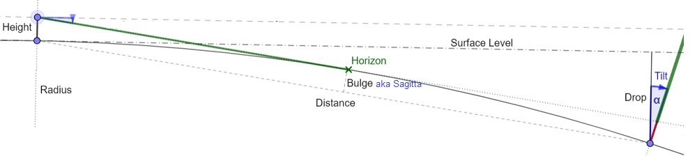
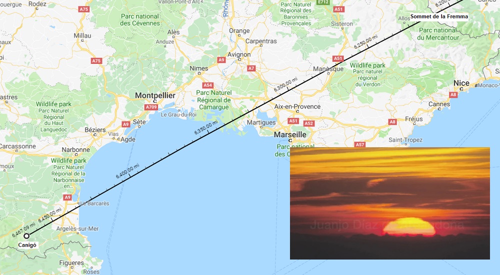
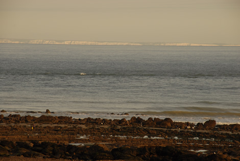
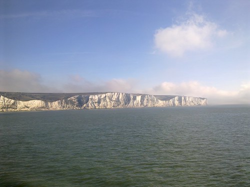
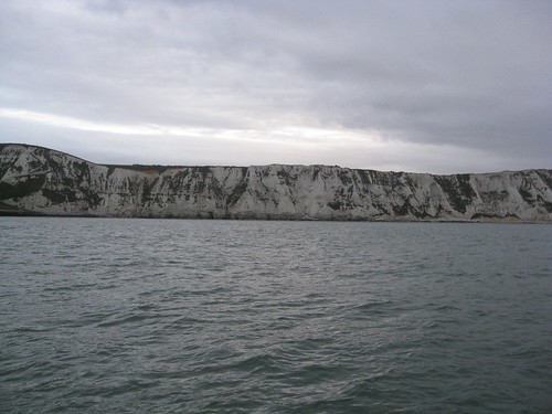
1. Occlusion

On a globe earth (GE), the sun "sets" due to the rotation of the earth and occlusion of the sun by a horizon. A horizon presents a physical barrier to visual line of sight that "cuts off" the sun, first from below like a "sinking ship" effect.


Various flat earth (FE) hypotheses attempt to explain sunset: spotlight pattern, extinction and/or compression by the atmoplane, perspective (plus surface irregularities), mechanisms that cause light to bend upward creating the illusion of the sun nearing the horizon and a bottom-up occlusion of the sun by the horizon.

My conclusion is these FE explanations are either flawed, unsubstantiated or don't integrate well with explanations for other observable phenomena. And if Occam's Razor has merit, the simple GE explanation is elegant, predictable and consistent. As a solitary argument/observation, the explanation(so) for the sun's occlusion at sunset might not be enough to resolve the FE/GE question, which is why I think, collectively with the following, it does...at least in my opinion.

2. Constant Angular Width + Diminished Angular Height

The sun maintains the same angular width throughout the day. It is only within a few degrees of the horizon that the sun can appear "squashed" in the vertical yet nearly unchanged in the horizontal. On a GE, this is explained by an atmosphere that causes light to refract toward the surface of a spherical earth as the angle of incidence changes. Due to at curvature of the atmosphere and the oblique angle of the sun's rays, the lower limb of the sun is refracted more than the upper limb. As the rays pass through density changes of the atmosphere, the atmosphere itself curves, and upper/lower limb sunlight is refracted differently, thus causing the sun to "squash."

For a FE atmoplane over a flat earth, the effect would not be the same. For theories in which upward bending light explains the sun's apparent descent and occlusion by a horizon, the effect would be the opposite, causing the sun to appear elongated vice squashed.

I haven't seen it proposed, but atmoplanar "lensing" theorized to explain why a sun receding into the distance doesn't get smaller in appearance could be modified to say such lensing is imperfect and doesn't magnify the sun equally in the vertical dimension as it does the horizontal, but without evidence of how this atmoplanar mechanism works this is but an ad hoc theory.

3. Angle of Descent

North of the Tropic of Cancer, the sun always sets angling toward the north. South of the Tropic of Capricorn, the sun always sets angling toward the south. Between the Tropics, the angle of descent varies depending on the time of year.

This is explicable on a spinning globe with the sun's ecliptic being oblique. No theory (that I've seen, anyway) has been offered to explain this phenomenon on a flat earth.


4. Rate of Descent

The sun maintains a constant rate of angular passage of about 0.5° ever 2 1/2 minutes throughout most of the day. At low angles to the horizon, however, the sun's rate of descent appears to slow.

I don't believe I ever posted about this before. I'd heard about it, but never checked it myself until last night:


On a GE with an atmosphere, this is explained by atmospheric refraction and is the same reason as #2 above. Light from the sun bending toward the curve of the earth due to the changing density encountered by a curved atmosphere causes the sun to appear higher in the sky than it is astronomically. Without an atmosphere, the sun's apparent rate of descent would be constant; but with atmospheric refraction, the sun appears to slow as the effect increases until overtaken by occlusion (#1).

As far as I am aware, FE with an atmoplane has not addressed this. But like #2, the impact of an atmoplane and in combination with the theories offered for why the sun is perceived to be at such a low angle of elevation, the explanation used for GE+atmosphere doesn't work. A FE+atmoplane must have a different explanation.

5. Green Flash

I also don't believe I've ever presented this argument before, but the chromatic prisming of sunlight at sunset is real:


Commonly called the "green flash," it is explained by the same mechanism of atmospheric refraction responsible for #2 and #4 above.

And just as with those phenomena, a FE with an atmoplane must have a different explanation since the globe earth + atmosphere explanation doesn't translate to planar topography. And any upward-bending light mechanisms to explain a flat earth sunset would produce a "green flash" on the bottom of the sun vice the top (or a "red flash" on the top rather than a 'green flash').


----

I propose that these sunset observations: occlusion + shape/size + angle of descent + rate of descent + green flash; are explicable by a globe earth model and that no flat earth model has as yet done the same. I welcome discussion to the contrary and in defense of a flat earth model.

19
Flat Earth Theory / Viewing Carlsbad from La Jolla
« on: October 11, 2018, 10:11:30 PM »
Posted this in an AR forum topic, but felt it warranted its own discussion topic in the Flat Earth Theory forum where it might reach a wider viewing audience, as long as it's divorced from the issues of the rest of that AR topic.

Yesterday in late afternoon (10/10/2018), about an hour before sunset, I made some visual sightings across a 20-mile over-water stretch from La Jolla, CA's "Children's Pool" seafront area to Carlsbad, CA to the north:


The visual target was Encina Power Station with its still-standing~400' smokestack:


It made spotting observations from 3 points of differing elevations:


From 25 feet:


From 10 feet:


From 0 feet:


The tide was just past its low, at 0.0, which is -2.8' Mean Sea Level (MSL) for La Jolla.
A light on-shore wind chop was was on the water, with a primary South-Southwest swell of 4-5' at 12 second intervals.
Lifeguard station listed air temperature as 70°F and water temperature 66°F.
 
The sightings from each spot elevation was observed to coincide closely with what earth curve calculations predict with standard atmospheric refraction applied:


All images were taken at max focal length (215mm-equivalent) with Canon Powershot SX50 HS. Images above were color/contrast adjusted and cropped with original resolution intact.

I feel this is yet another case where my personally-conducted observational evidence appears to support a convex earth surface and presents a challenge to the flat earth model. As always, I invite critique and criticism on either the method, observation or conclusions.

20
Flat Earth Theory / Viewing Cliffs of Dover from Cap Gris Nez
« on: October 07, 2018, 02:26:11 PM »
Can you see all of the Cliffs of Dover from France? This post lifted from another topic claims yes. "No curvature whatsoever."

What do you think? Is this convincing evidence of earth's lack of rotundity?

Quote

The English Channel: 34 km distance from Cap Gris Nez to Dover, a curvature of some 22.4 meters on a round earth.


The original webpages, as they were posted on flickr.com

The photographers located between Cap Blanc Nez and Cap Gris Nez: we will ascend to 30 meters.


And now the photograph itself: no curvature whatsoever, all the way to the other shoreline, the Dover cliffs seen in their entirety (on a round earth, from 30 meters, we could not see anything under 16.5 meters from the other side), the ships are not part of an ascending/descending slope, no midpoint curvature of 22.4 meters:


Another photograph taken right on the beach of Cap Gris Nez: no curvature over a distance of 34 km:


Dover cliffs:


Pages: [1] 2 3  Next >