1
Flat Earth Projects / Re: The Atlantic Split
« on: December 19, 2022, 03:39:38 PM »I am looking into a variant map to the Bi-Polar model, which I call the Atlantic Split. In this variant the split occurs in the Atlantic Ocean rather than the Pacific Ocean.
Link to Bi-Polar Model overview: https://wiki.tfes.org/Bi-Polar_Model
I was able to derive a rough draft version the Atlantic Split as generated from an old version of the nullschool webapp: https://web.archive.org/web/20170731230036/https://earth.nullschool.net/#current/ocean/surface/currents/overlay=primary_waves/azimuthal_equidistant=-205.32,21.99,115/loc=154.680,-89.951
Now, the continents might not look exactly like that, as this website has limited ways to warp the map. My idea of the Atlantic Split is that the African and South American continents are on the Left and Right sides of the world, with the other landmasses in some configuration in between. Africa or South America might be smaller or less warped in shape than what is depicted. Again, there is limited control over this aid map. The continents South America and Africa should be considered to be blobs on the sides of the map.
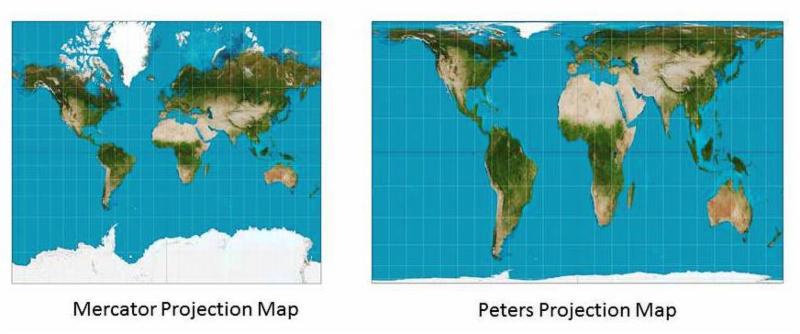
At first glance Africa and South America seem quite abnormal, as compared to the ones we see on the Mercator Map. However, consider the Peter's Projection. The Peter's Projection supposedly provides a more accurate depiction of the continents in terms of land mass. The size of Africa and South America are much bigger in this map.
https://www.oxfordcartographers.com/our-maps/peters-projection-map/QuoteMaps not only represent the world, they shape the way we see it. The revolutionary Peters Projection map presents countries in their true proportion to one another: it has been adopted by the UN, aid agencies, schools and businesses around the world.
WHAT IS THE PETERS MAP
The Peters World Map is an Equal Area cylindrical projection with standard parallels at 45 degrees thus resulting in a distortion of shape which is stretched about the equator and squashed towards the poles, but having the great advantage that all countries are correct in size in relation to each other.
So, it is possible that Africa and South America are much larger than normally depicted.

A gent in my yacht club is currently competing in the Golden Globe round the world yacht race. The course that he (and the rest of the competitors) has followed would be impossible if that map was even close to reality: https://goldengloberace.com/live-tracker/
Back to the drawing board, I'm afraid.