Show Posts

This section allows you to view all posts made by this member. Note that you can only see posts made in areas you currently have access to.


Messages - troolon

Pages: < Back  1 2 [3] 4 5 6  Next >
41
Flat Earth Theory / Re: Found a fully working flat earth model?
« on: February 08, 2022, 10:22:59 PM »
I don't get what all the fuss is about, really, unless I've missed something.
Based on your reactin, you have probably totally understood.
From a physics viewpoint this model has nothing new to offer.
However in the context of the flat-earth-"debate", it offers a few interesting tidbits:
- There exists a working flat-earth model. People have been looking for this for over 100 years
- The true shape of the earth can never be known. It can be a globe, or flat or a pyramid. There's no way to measure it. It seems people do not always realize this.

But yes, you have probably understood everything correctly and your reaction is very typical for a physics graduate.

42
Flat Earth Theory / Re: Found a fully working flat earth model?
« on: February 08, 2022, 10:12:34 PM »
...
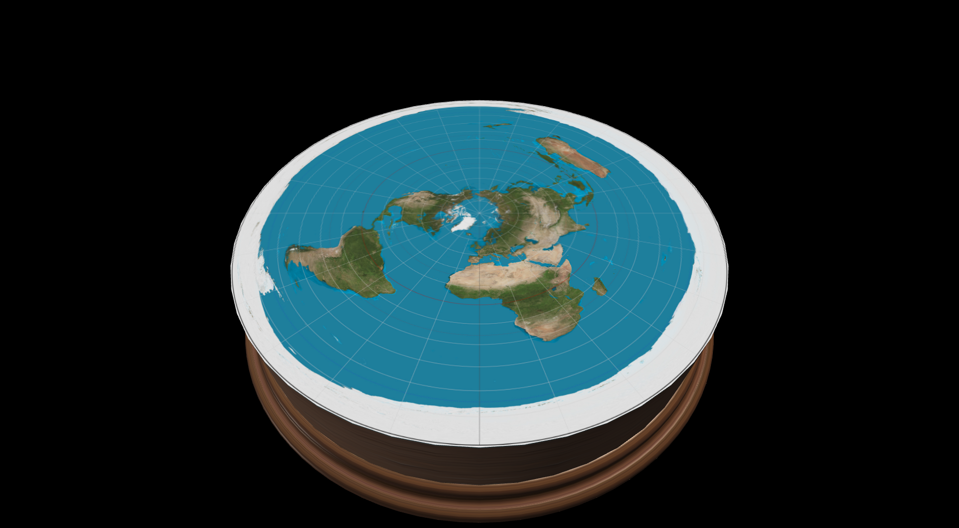
Because we are only interested in the earth, we can ignore all of the stack of disks except the one with the radius of the earth. You can shorten the statement to "take the earth and transform it into a disc". This is not changing coordinate systems, this is just flattening the disk, just like the maps in the FAQ and with the same distortion.
Why would a flattening not be a coordinate transformation? You can go back and forth between them, no information loss. The surface of a sphere is a 2D structure, so it a disc. Here's the transform to go back and forth between both:
(lat, lon, dist) = (asin(z / √(x²+y²+z²)), atan2(y, x), √(x²+y²+z²))
(x,y,z) = (dist * cos(lat) * cos(lon), dist * cos(lat) * sin(lon), dist *sin(lat))

Quote
If you represent the same sphere in different coordinate systems and use the equations for that coordinate system, you will get the same distances, shape, size in all coordinate systems. To convert a sphere in cartessian to spherical, find the instructions here:
In all coordinate systems, you will end up with a sphere where every point is equidistant from the origin. Your AE/FE projection does not do that, so not a sphere.
Please remember that on a sphere in spherical coordinates, coordinates are expressed as (lat, lon). Or degrees along the equator-circle+ degrees along the NS-circle. In the flat rendering points are still expressed as degrees along the equator-circle+ degrees along the NS-line
I know this sounds counterintuitive as we use cartesian coordinates so often, but on the cylinder, the 3 axis are the equator, NS-line and height. Any point is expressed as a "sum of these 3 axis".  When using these 3 axis, all points are indeed equidistant from the center of the earth.
The easiest way to show is:   center of the earth in spherical coords = (0,0,0). Any point on the flat earth has coordinates([0-π], [0-2π], 6000km). The distance between any point and the origin is exactly 6000km. Exactly as expected.
Do note that if we represent coordinates in cartesian form (x,y,z) and then calculate the distance, everything will be broken. You must respect the axis.

Quote
On a spherical earth, longitude lines below the equator converge, get closer together. On disk earth (FE/AE) they diverge. Case in point, the coasts of Australia. If we take their longitude as the same on RE and FE, on RE the longitude lines are closer than the equator, less distant. On FE, they diverge, the lines are farther apart, more distance. Distance is not preserved, not equivalent. This is what happens when you "straighten the longitude lines". Distance is distorted. The appearance of the AE confirms that Australia is way too wide. We can do the calculations of what the distance would be with converging longitudinal lines and diverging. Only one can match, the other will be falsified.
Remember our axis are the "equator" and NS-line. On a sphere, points are expressed as (lat/lon) -- degrees along the equator + degrees on the NS-circle. On the flat earth they are too. When you express coords as lat/lon, you should use the lat/lon distance formulas (ie haversine) and Australia will have the correct width also on the flat earth.
To give a quick example. the left-most point of australia on the flat map has coord (-33°, 115°). The rightmost point (-29°, 154°). Calculating the distance gives: 3722km (which matches google maps and the globe model)
Calculating the distance with xy-coordinates will indeed give horribly deformed results.

Quote
Still wondering where Sigma Octantus is. Do I understand your reply to be that you can make a graphic of Sigma Octantus light bending however it needs to so that everyone in the southern hemisphere sees it directly south at an angle of inclination equal to their latitude? Perhaps, like the shape of the earth, no one can ever know? Seems like a pretty weird coincidence that the light would bend however it needs to to make Polaris be directly north at an angle of inclination equal to your latitude.
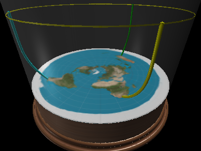
If you had asked for 3 people looking north and seeing polaris, the answer would be really straightforward on the disc. Draw a star above the northpole, draw curvy rays from the 3 observers going to the star and done.
To understand the southstar, there's one peculiarity about the AE map you must understand: The southpole, a single point on the globe, gets transformed into a circle. The entire outer edge of the AE map represents just 1 point in reality. Mathematically: the southpole has coordinate (lat,lon) = (-90°, [0-2π]) There is no unique coordinate for this point.
The same phenomenon happens with points directly below the southpole: it gets transformed into a circle. So the southstar in the flat earth universe is rendered as a circle rather than a point. It's rather obvious that 3 people looking south, can see the same circle.
If we move the southstar just the slightest bit away from the southpole, it would again become a single point. When you then draw the rays of light, you will see they start due south from the observer, and then start curving all around the disc to meet up with the southstar. I can promise you, mathematically it is all correct even though it's not very intuitive.

Quote
Do you agree that RE geometry explains this with straight light and a reasonable location for Sigma Octantus? That on FE, no one knows where Sigma Octantus is or how or why the light bends?
Re explains the world very well.
On FE, sigma octantis position is given by (lat, lon, distance). We know perfectly well where it is.
The reason light bends in the FE rendering is the same reason light travels straight in RE.
Remember both RE and FE share the same physics. There's not difference. It's just a different representation.

43
Flat Earth Theory / Re: Found a fully working flat earth model?
« on: February 06, 2022, 09:13:45 PM »
You continue to miss the point.
At least one of us does :)
Can you please answer the question i've asked multiple times before. At what point do you believe the transformation breaks?
1. When i'm switching from cartesian to celestial coords,
2. or when i'm drawing latitude on a straight axis instead of a curved axis?

Quote
Even though the geodetic (Lat,Long,Alt) coordinates of the magenta vectors are the same on the Globe and Flat Earth domain, the corresponding vectors are not the same.
Quote
FYI: The link only contains black/white pictures. I did not find magenta vectors

Quote
Just because the coordinates are the same, doesn't mean that mathematically it is a sphere.  A sphere has the least amount of surface area per volume of any shape.  ...
Even though the geodetic (Lat,Long,Alt) coordinates of the magenta vectors are the same on the Globe and Flat Earth domain, the corresponding vectors are not the same. They have different directions and lengths and hence different cartesian coordinates. The lengths of the magenta vectors are shown at |Vglobe| and |Vfe| respectively
But my vectors are the same...  A point in celestial coords can be expressed in terms of its vectors as:  x*latitude-vector + y*longitude_vector + z*distance-vector.
(note i'm using vector very liberal here as latitude and longitude are a circular and not straight axis. It's probably more logical to express a point as distance along the equator plus distance along the northpole-southpole-greatcircle)
On the flat cylinder, the same point is still expressed as: x*latitude-vector + y*longitude_vector + z*distance-vector.

So as far as the math is concerned, these 2 points are the same. Same values, same vectors

Quote
The vectors represent a measurement of area.  So even though the coordinates are the same, the coordinates represent a different measurement of area. That’s exactly what is not supposed to happen when you transform coordinates from one system to another.  If you transform the metric tensor correctly, the coordinates in any system should represent the same amount of area in any other system.
area is the same as axis and coordinates of any point are the same.
eg: in celestial coords, the sphere with equation lat=[0-π], long=[0-2π], distance<=R  has volume 4πR²
The flat cylinder with equation  lat=[0-π], long=[0-2π], distance<=R  also has volume 4πR²
There is no difference.

Quote
Note: Coordinate System Transformations (CS Transf) do not change the length and direction of vectors. They only change the values of the vector components to get the same vector in the corresponding coordinate system.
Translation: A correctly performed transformation doesn't change the amount of surface area.
Sure, you can manipulate the same volume of space of a sphere and plot it on a disc, but you have to ignore the rules about transforming the metric tensor and therefore aren’t represent reality. You can change the shape of anything to look like anything, but if you ignore the rules of physics doing so, it isn’t much of an accomplishment.
I'm not ignoring any rules. In fact i'm relying on all these rules not to break the physics. If distances or vectors changed, everything would break.
It's just a different representation, but it are celesitial coordinates. You should calculate distances, angles and areas, with to celestial coordinate formulas.

44
Flat Earth Theory / Re: Found a fully working flat earth model?
« on: February 06, 2022, 04:51:11 PM »
the distances are the same no matter what coordinate system you use
agreed
Quote
The whole point of coordinate transformations is that you don’t change the physical nature or geometry of the underlying structure.  If your transformation results in different distances between points and you have to use a "bendy ruler" to make the distances work, that is exactly what you have done.
agreed again.
The width of Australia should be around 4000km whether calculated in cartesian or celestial coords.
I believe the only discussion we are still having is that i'm claiming the picture below is a sphere expressed in celestial coords, whereas you believe it's a disc expressed in cartesian coords.
Just looking at the width of Australia, we can be pretty sure, cartesian coords are incorrect. When looked at in celestial coords, distances do match with the globe model.

Mathematically the above picture is a sphere. Just like the 2 graphs below are both representations of the same sine function yet look totally different. Math only cares about numbers, not shapes.

And this brings us back to my original point: physics works regardless of shape. It only cares the numbers and formulas are correct and surprising enough, the numbers work on different shapes... ergo  the shape of the planet can never be known.

45
Flat Earth Theory / Re: Found a fully working flat earth model?
« on: February 05, 2022, 10:26:27 PM »
Can they? Because on a flat earth, they'd have to reflect off something. There's no connection between one edge and the other, correct?

And once waves reflect, they won't return to the same spot, unless the wave starts from the very center of the transformation.
The boundary of the disc is nothing but a mathematical artifact. Things crossing the southpole, appear at the other end of the map.

But as a general answer, my 3D model is globe physics, just rendered differently. If you take a globe, express it in in celestial coords (lat, long, distance), and then draw latitude on a straight instead of a radial axis, you'll get a flat-earth-universe. Physics works with celestial coords, and so it behaves like a globe, it just looks flat. So if a wave works on a globe, it also works on the flat renderering. The only difference is the shape of one axis.

46
Flat Earth Theory / Re: Found a fully working flat earth model?
« on: February 05, 2022, 10:20:20 PM »
I'm not sure this is entirely relevant, but it kind of looks similar to the creation of the model. Troolon, you may (or may not) find this interesting:

Transforming from Geographic to Celestial Coordinates
Awesome, thanks!
I was already looking for a way to convert RA/dec to lat/long at a given time. If only to make the simulation more realistic.

47
Flat Earth Theory / Re: Found a fully working flat earth model?
« on: February 05, 2022, 08:46:39 PM »
Show a wave expanding from a non-central point and returning to the same point in the proposed FE model.
ScienceItOut made a video showing that:

But you might be missing the point: If an expanding wave can be explained by the globe model, so it can in my model. They're equivalent.

48
Flat Earth Theory / Re: Found a fully working flat earth model?
« on: February 05, 2022, 12:37:01 PM »
if we have 2 different shaped models, that can explain everything, we can't ever be sure of the shape of the earth.
If you find yourself at this kind of impasse, you need to look outside your models, then. ("This model is nothing more than mathematical trickery.", you said)
Take yourself away from your desk, go out into the world, and gather some data.
There is no way to differentiate the models. No test. You may gather any data you like, and both models will return the same prediction each and every time.

49
Flat Earth Theory / Re: Found a fully working flat earth model?
« on: February 05, 2022, 12:34:02 PM »
Quote
It's like claiming i broke physics because i drew my graph in red pen instead of a black one.
Its a lot more complicated that that
My transformation is twofold. Can you please help me understand which of these 2 steps you believe breaks curvature:
- convert everything to celestial coordinates (lat, long, distance)
  This transformation is used in physics all the time and just expressing a sphere in celestial coords doesn't break distances or curvature. (the distance formula does of course get transformed along with the coordinates, just like when physics switches to/from celestial coords)
- Please have a look at the two graphs below. One in "polar coordinates", the other one in "cartesian coords".
  These are both visualizations of the same function, In the "polar" visualization, the X axis is radial around the origin. In the "cartesian" rendering it's a straight line. Both graphs represent the same function and mathematically the functions curvature doesn't change, when plotted differently. From here stems the red/black pen analogy. FE/RE is just a representation of the same physics/mathematics.
 
Quote
The question is did you transform the metric correctly? ....
I believe so. I would use the same distance metric physics normally uses when switching to celestial coords.
Or more formally:  distance_in_celest(p1, p2) = distance_in_cart(celest_to_cart(p1), celest_to_cart(p2))
So basically same formula after appyling the inverse transform.
I'm not proposing to do the celestial coordinate transformation any different than physics does it today.

Quote
When you correctly transform the metric when transforming from a spherical to a flat coordinate system, you get distortion, as explained here.
You're now sneakily going back to an orthonormal basis. When you take a non-orthonormal basis (like celestial coords) and start measuring it with a "straight" ruler, indeed nothing will match up. If i take my curved polar-coordinate-ruler to your globe, everything will be broken too.

Quote
You broke physics by making up your own rules for transforming the metric tensor. If you don't have any distortion in your model, you didn't transform the metric correctly and have changed the geometry.
Take the cartesian point (1,1).  distance to the origin is √x²+y² or    √2.
Express the point in polar coords: (45°, √2). The original distance formula is now invalid. The correct formula (in general) would be:
    distance_in_polar(p) = distance_in_cart(polar_to_cart(p))

So in summary i agree with all the math you've presented. However the distortion only appears once you treat the transformed coordinates as orthonormal.
In my model you do indeed lose the possibility to measure distances with a "straight" ruler.

50
Flat Earth Theory / Re: Found a fully working flat earth model?
« on: February 05, 2022, 11:36:12 AM »
I think the problem is twofold, jimster. First, you can't spell Sigma Octantis at all and apparently refuse to even check. Second, and probably more importantly,  you haven't bothered actually reading anything troolon has written about the model, because had you done that, you'd at least recognize the fact that objects map identically in the standard RE framework as they do in troolon's FE model. You've completely ignored the distance metric that is widely different than the ruler you are used to as well as the coordinate transformation. The knee-jerk reaction people seem to have to anyone that even gives a hint that they might be non combative toward FE is astounding to behold.

Troolon, I admire your patience. This is a neat construction you've presented here, and clearly done a lot of work to flesh out and demonstrate.
Thank you very much.

51
Flat Earth Theory / Re: Found a fully working flat earth model?
« on: February 05, 2022, 10:12:34 AM »
If someone is at 80 degrees south latitude, where is Sigma Octatus? It appears as a point 10 degrees south of directly overhead for observers anywhere on that latitude. For observers at 70 degrees south, it appears 20 degrees south of directly overhead. The points at each latitude will form a circle, so you need lots of circles, not just one. If you had observers over the entire hemisphere, Sigma Octatus would cover the entire dome. It appears at every point around the circumference and at every angle of inclination.
I can't say it any better than Clyde Frog
https://forum.tfes.org/index.php?topic=19093.msg258141#msg258141
It is the RE model you're debunking...

52
Flat Earth Theory / Re: Found a fully working flat earth model?
« on: February 05, 2022, 10:07:23 AM »
I could write an equation to do a transform of globe to a single point. You keep saying it is all the same, but it isn't. You can figure out distances on FE with triangles. You can't do that on RE, you need trig. Your transform goes from a sphere to a plane, the very definition of FE. The distance equations are different on a sphere and a plane.
Yes! A coord transform can change any shape into pretty much any other shape (not a point though, that would break the physics)
But in physics you have to transform the formulas together with the coordinates.
In cartesian space, distance is calculated with √(x²+y²+z²). When you switch to celestial coords or polar coords or ...  this formula goes out the window. You have to use the appropriate distance formula for your coordinate system.
Your claim that i have to use the cartesian distance formula, on spherical coordinates will indeed break everything. Of course i can see Australia doesn't measure on the AE map in cartesian distances. The only conclusion we can draw is that cartesian distances are the wrong formula on the AE cylinder.

I guess you want to have your idea more than you want to do math right.
The math is right. I wouldn't have published it if it weren't first scrutinized by various physicists...

Proof by contradiction: assume the earth is flat. Observe this leads to a map with wrong distances. QED, FE is falsw.
To correctly state your proof:
Assume the earth is flat and we're using the cartesian distance formula.
Observe the leads to a map with wrong distances
-> conclusion: flat earth can not work with cartesian distances

53
Flat Earth Theory / Re: Found a fully working flat earth model?
« on: February 05, 2022, 09:54:50 AM »
The curvature of a plane (FE) is zero. Whatever the curvature of a sphere is, it is not zero, that's all you need to know for Gauss. Draw a map on a piece of paper, then wrap it around a globe. You will have to tear or wrinkle it, that represents distance errors.
See https://forum.tfes.org/index.php?topic=19093.msg258073#msg258073 .
As i've tried to explained many times, my model is a sphere in celestial coordinates.
But instead of drawing latitude on a radial axis, i draw it on a straight one. As earth radius is so unfathomably big, this is not an unreasonable assumption even...
The drawing is just a representation, it does not change the math.
You're trying to prove that a sphere loses it's curvature when it's expressed in celestial coords

If the distance is about 7000 miles, the earth is round. If the distance is 16,000 miles, the earth is flat. There is an airline flight, they fly at 500 mph. On FE, this flight would be 32 hours long and far longer than the range of any airliner....
This is a very disingenuous argument. I've said countless times before, you should use celestial coordinate geometry (ie haversine et al) to calculate distances.
What you're doing is akin to taking my model, changing all the formulas and then saying it doesn't work.
My model is the globe model, expressed in celestial coords. Please don't use sqrt(x²+y²+z²) for celestial coords

On RE, you need spherical coordinates and haversines (or equiv trig). On FE/AE, it is easy to make a 2d triangle and all you need is elementary 2d geometry. ...
My model is working in celestial coordinates. It's just not drawn the conventional way, but it are celestial coords.
Of course 2D geometry will break on celestial coords.
You're trying to convince people to use cartesian formulas on celestial coords. This reasoning would break half of physics....

54
Flat Earth Theory / Re: Found a fully working flat earth model?
« on: February 05, 2022, 12:18:52 AM »
Yup, stand at the top of one building, align a spirit level or similar to show horizontal, and the line drawn along that level does not meet the building of similar height some distance away, as you would expect it to do if the Earth were flat.
If light curves upward, that would be rather logical.
My model is the globe model coord transformed. (if even that). So if the globe can explain it, so can mine.
I've taken the globe model, removed the curve and contorted anything to make the math match.

Or, stand at a set height (210m in one example), look at an object of 210m some km distant, and find that the sightline between the two does not meet the hills of 400m+ behind at 210m, where it should if the Earth were flat, but passes clear over them.
light curving explains that as well. The light curves in such a way it compensates the missing curvature of the earth

Practical stuff that shows, regardless of your model, that the Earth is Not Flat.
This model is nothing more than mathematical trickery.
There is no test to differentiate the two models. And if we have 2 different shaped models, that can explain everything, we can't ever be sure of the shape of the earth.

55
Flat Earth Theory / Re: Found a fully working flat earth model?
« on: February 04, 2022, 11:45:15 PM »
You need curved light AND a "lampshade" or directional beam sun.

In reality you can't see "below" the horizon. This is why ships disappear keel-first.
When you create the horizon-equation (horizon here meaning the line you can't see below), you will see it curves up towards infinity in all directions, creating a cone around the observer.
As you can't see below the horizon, you also can't see outside the cone.
From the viewpoint of the sun, light travels in all angles towards the earth. However the curvature of the light on the non-lit hemisphere, is so extreme the light curves back into space without hitting the earth. There's no need for lampshades when curving makes the light miss the earth.

BTW, as an answer to all your questions:
- draw your question as the globe prescribes (ie draw lightrays a sun and a earth).
- express all elements in polar coords
- draw as a flat earth. (ie put latitude on a straight instead of a radial axis)
It all works because this model IS the globe model.  Anything the globe can explain, so can this model...
Physics cares about numbers, not shapes.
We'll never know the shape of the earth (if it even has a shape)

56
Flat Earth Theory / Re: Found a fully working flat earth model?
« on: February 04, 2022, 11:35:23 PM »
In your diagramme above, what would I experience if I was stood on the top of the tower block, looking at the person on the right? Would they appear to be a lot lower than they actually were in reality? (Let’s remove the boat for the moment)
The light curves exactly the opposite way the earth would have curved on a globe.
On a globe, 2 buildings are not parallel, they slightly veer out due to the curvature, and so on a globe you would also look slightly down to see the other person.

     \ __ /          <- two very tall buildings not being parallel due to curvature.       
     /     \           <- wannabe globe ;)
      \__/

57
Flat Earth Theory / Re: Found a fully working flat earth model?
« on: February 04, 2022, 11:25:42 PM »
Please explain where Sigma Octatus is.
On the AE map, where is the southpole? It gets deformed into the circle around the edge of the disc.
In my map, the southstar also gets deformed into a circle. Once you have a latitude that's even slightly off of -90°, it will become a point again.
So in the image below, the southstar is the yellow circle, and you can see all 3 observers see the circle due south.
You asked me to drarw the most abhorrent case on the AE cylinder, you shouldn't be surprised it looks weird :)
(btw on the globe, the southpole has no unique coordinates: lat=-90, long=[0-2π] which explains this result)

Once again this FE model can explain anything the globe model can because... it is the globe model.

58
Flat Earth Theory / Re: Found a fully working flat earth model?
« on: February 04, 2022, 09:34:41 PM »
Where is sigma octatus?
In my model: express sigma octatis as (lat, long, distance) from the center of the earth
Draw lat/long as on a AE map and place that in a cylinder at height `distance`
ie long on a radial axis, lat on a straight axis, distance in the up direction.

59
Flat Earth Theory / Re: Found a fully working flat earth model?
« on: February 04, 2022, 09:31:27 PM »
RET explains this, diagrams available in science textbooks. Is there a corresponding diagram and explanation for FE?

Where is sigma octatus?
Yes, check my model. Anything physics can explain, my model can do because it's the same model.
Physics works regardless of shape.
FE proof = express everything in spherical coords; proof in RE; express result in celestial coord again.
(or you can derive all formulas by hand, but that will take a while longer)

60
Flat Earth Theory / Re: Found a fully working flat earth model?
« on: February 04, 2022, 09:26:34 PM »
You just need to look out your window at the Moon and celestial bodies to know that the straight line nature of light on a celestial scale is incorrect.

... but it's perfectly straight at this scale?

Straight like this? :)


Pages: < Back  1 2 [3] 4 5 6  Next >