Show Posts

This section allows you to view all posts made by this member. Note that you can only see posts made in areas you currently have access to.


Topics - Tom Haws

Pages: [1]
1
This is just for fun since anybody can do it at any time. This is a test of the view from Malibu to Torrance,

Go to Corral Canyon Bridge on Pacific Coast Highway at Malibu. Go ahead. Do it in Google Street view.
34.0333365,-118.7345869

Look at the panorama from east to south.

The mainland is visible at about 3:30 to 4:00.
Palos Verdes Rolling Hills is visible at about 4:30, not quite connected to the mainland. You can't see Torrance or any white shoreline.
When conditions are right, Catalina Island is visible at about 5:30.


Step back a couple of miles and up 1600 feet to

Corral Canyon Road near (above or below) Baller Motorway
34.068006,-118.7533566

Palos Verdes Rolling Hills is visible, very much connected to the mainland. Continuous white shoreline is visible with Torrance above it.
When conditions are right, Catalina Island is visible (not well on this day).


No assertions. Just a fun experiment from home. It might be fun to post other similar location experiments in this thread.

2
Flat Earth Theory / Sundial
« on: December 17, 2017, 11:41:56 PM »
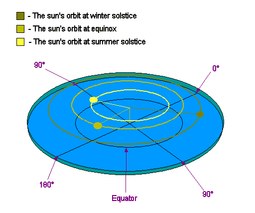
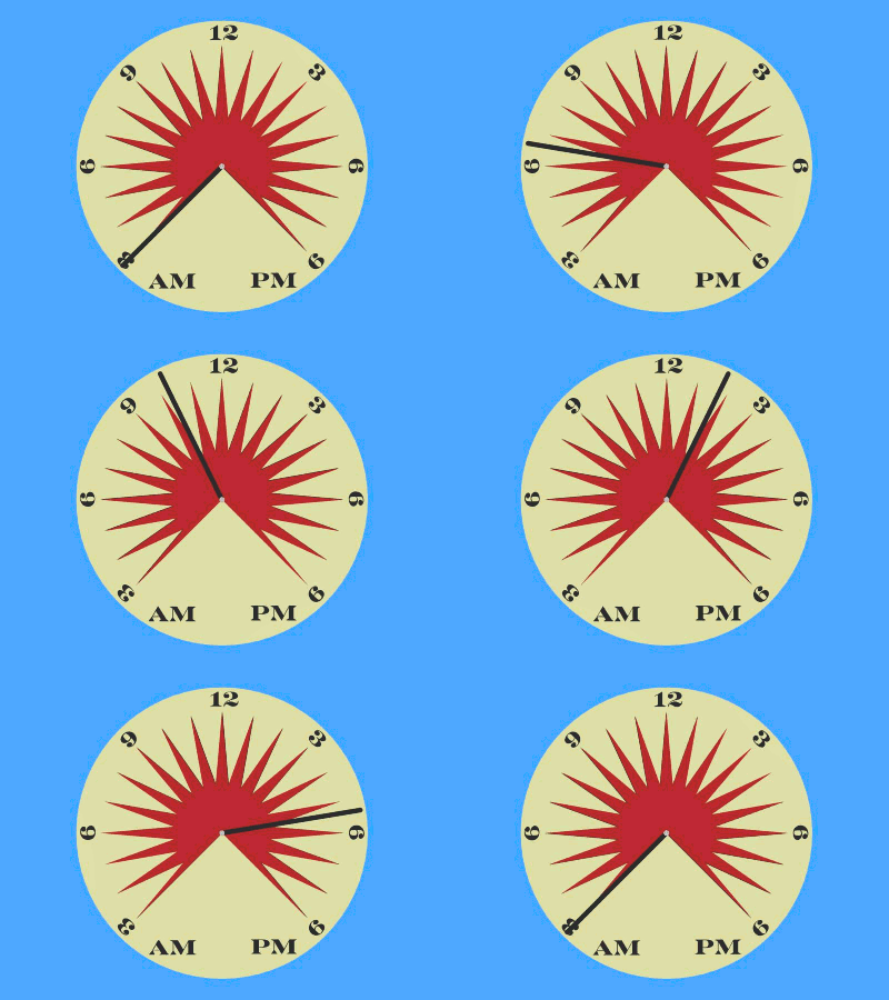
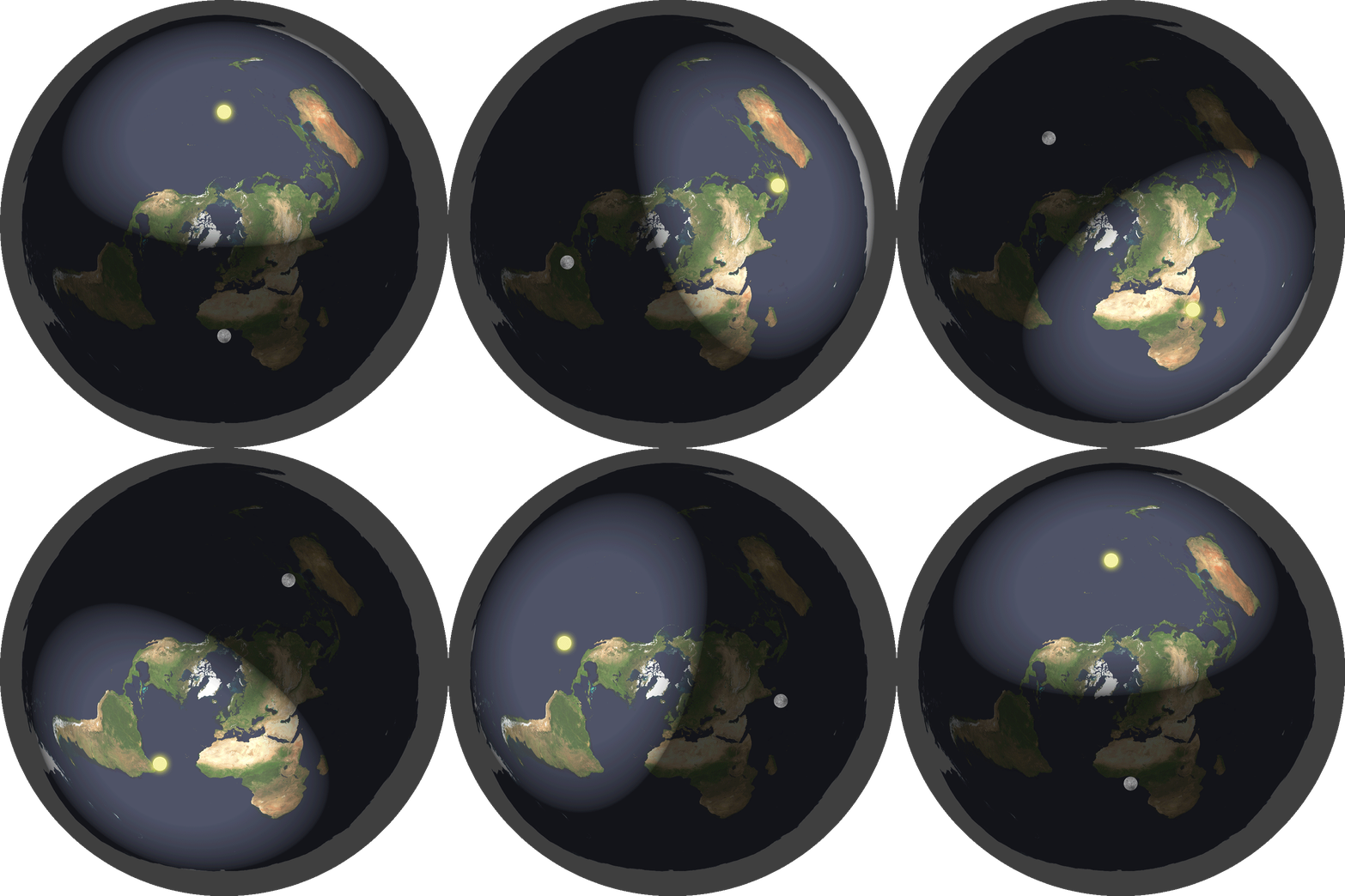
A quick search of the site for the terms "sundial" and "dial" reveals little "dial"ogue on the subject. But this site's model of the sun cannot operate all sundials correctly. I'm including the following images:

1. A working sundial located in Singapore

2. An animation of a generic equatorial sundial with a flat dial.

3. The FES Sun animation.

4. The FES seasons illustration

To make a sundial work the way it works, the Sun must be apparently traversing a constant speed arc across the sky. For a given point on earth, there are various ways this could work, including a) the sun orbiting the earth, b) the earth rotating on its axis, and c) the sun passing overhead at variable speed. But for all points on earth, this cannot work by method c.

The FES Sun animation does not make the sun apparently traverse a constant speed arc across the sky. And of course undulations necessary for the moon phases complicate the problem.

Sundials come in many designs, and sundials have been used for over 3000 years. Consider this sundial with a curved dial located in Singapore, almost at the equator. Also consider the generic equatorial sundial animation. Both required the Sun to traverse the apparent constant speed (tangential or angular) arc.

1. A working sundial located in Singapore


2. An animation of a generic equatorial sundial with a flat dial.


3. The FES Sun animation.


4. The FES seasons illustration


3
Flat Earth Theory / Wiki on Eratosthenes
« on: December 13, 2017, 05:02:10 PM »
I very strongly disagree that this is a point of debate. There is no room for debate about basic geometry. But I was told this is not a subject for the Suggestions board. So I am putting it here. Ludicrous.

Thesis: The very short and accessible Wiki Article on Eratosthenes is nonsense.

Quote from: Wiki Article on Eratosthenes
We can use Eratosthenes' shadow experiment to determine the diameter of the flat earth.

Syene and Alexandria are two North-South points with a distance of 500 nautical miles. Eratosthenes discovered through the shadow experiment that while the sun was exactly overhead of one city, it was 7°12' south of zenith at the other city.

7°12' makes a sweep of 1/25th of the FE's total longitude from 90°N to 90°S (radius).

Therefore we can take the distance of 500 nautical miles, multiply by 25, and find that the radius of the flat earth is about 12,250 nautical miles. Doubling that figure for the diameter we get a figure of 25,000 miles.

The wiki article on Eratosthenes assumes a round Earth. It appears to be assuming a round earth that is concave upward. That is the only possible way that the suggested calculation makes any sense at all.

With a flat Earth, the correct calculation gives a height of 4000 miles for the Sun, but it does not give any reasonable estimate for the size of the Earth. Using the coincidentally chosen cities of Alexandria and Syene, the 66th parallel south of the equator
(90 degrees of latitude south of Syene; the Antarctic peninsula) is an infinite distance to the south of Syene, and the 90th parallel north of the equator (the north pole) is 4000 miles times the tangent of 66 degrees, or nine thousand miles north of Syene. These distances would change if Eratosthenes had measured two different cities.

The given numbers for anyone who may be reading this thread without looking at the wiki article or without any faith in the wiki article are as follows:

Syene is on the Nile at approximately the Tropic of Cancer or 24 degrees. It is at the current site of Aswan.

Alexandria is roughly 500 Miles, 5000 stadia, or 8000 km north of Syene. Eratosthenes found the sun to be 7 degrees south of Alexandria when it was directly overhead at Syene.

4
Flat Earth Theory / FAQ and Sun chart
« on: December 13, 2017, 03:56:06 PM »
I am trying to understand "How do you explain day/night cycles and seasons?" in the FAQ. Can you point me to a sun chart that will allow me to go outside today and verify the position of the sun and moon in Mesa, Arizona based on the model presented? The chart should plot the following for a year at my location:

-Date
-Time
-Distance of sun
-Angle of elevation of sun
-Azimuth of sun (or bearing from north)

Kind of like these charts I have been using on my patio door for gardening. One chart is for standard time, and the other is for solar time.

5
I found this interesting page. There are some interesting observations and clarifications that arise from considering this world record photograph:

1. Sunrise and sunset are the best times to photograph extremely distant unlighted mountains and buildings because of the assistance of their being silhoutted against the sun.

2. The angle of view of the camera is about 2 degrees. So we are looking at a very small sliver of the view from 444km away. I added some annotation about angle to the last screenshot below.

3. Google Earth actually has Pic Lory in the French Alps invisible from the peaks near Nuria and Vallter, Andorra, Spain. I don't know if this is to save computation power, but a pythagorean calculation for the apparent 300 meters of visible peak in the photo yields a distance of pretty close to 444 km. I get 415 km. Since the distance is greater than what I calculated, we probably are seeing a bit more than 300 meters of the distant peaks.

Here are some screenshots I found interesting:


6
Flat Earth Community / Most people are flat earthers most of the time
« on: December 05, 2017, 08:24:21 PM »
When they do the job, flat earth (Euclidean) approximations are a lot easier to understand and a bit easier to use than spheroid approximations, ellipsoid approximations, or geoid approximations. In our daily work, nearly all of us are flat earthers when we can be. I think it would be fun to share examples from our professional lives of how we are flat earthers and the limits of those assumptions.

Here's a bit from my civil engineering career:

1. All the civil engineering plans I have ever drawn have been flat. In AutoCAD, they are drawn on a Cartesian plane. This generally works fine.
2. Nearly all the property lines and descriptions I have ever seen (all but the ones on county, state, or continental level) have been flat. This generally works fine. But I am not a GIS guy. :-D Ignorance is bliss.
3. When I survey with an optical level (a little telescope sort of like a transit or a theodolite that only views level and does not measure angles), I keep in mind only a vague and gentle notion that I should maybe try to keep my sightings equidistant from my level to minimize Round Earth errors. This generally works fine within 1/2 mile.
4. When I get more scientific about projecting a Cartesian plane onto a Round Earth for larger projects, I can choose from a published projection, probably either UTM or State Plane Coordinates, whereby a piece of paper has been wrapped without creasing onto a limited area of the earth to approximate that area as a cylindrical section or cone that can be unwrapped exactly onto a Cartesian plan. UTM wraps the entire earth with 60 six-degree longitudinal strips. The Arizona State plane system lays 3 strips longitudinally onto Arizona. Other State Plane coordinate systems lay strips latitudinally or wrap them conically depending on what fits the shape and location of the respective state.

Limitations:
1. All my projects are no more than a mile or two long. A surveyor in my office who worked right-of-way maps for the freeway loop system for the Phoenix Metro area had to go beyond flat earth approximations due to the metro area extent.
2. If you try to glue together too many properties, or if you try to describe too large a property according to surveyed measurements, it can't be plotted faithfully on a flat map.
3. You have to be more rigorous about level legs and gravity corrections if you are running regional level loops. My hat is off to early surveyors!
4. State plane and UTM projection approximations only work if you can limit your work to one zone. There is no hard boundary between zones, but any given zone works best at the location it was created for. The further you stray, the worse your fit gets, and the faster it gets worse, to the limit of absurdity and meaningless results. All my career work has been on the Arizona Central Zone.

7
Suggestions & Concerns / Wiki review
« on: December 02, 2017, 07:29:20 AM »
I may start reading the Wiki. As I do, I am bound to have review comments. Where is the right forum to post them?

8
Flat Earth Theory / Sun path
« on: November 27, 2017, 06:17:53 AM »
Is there a thread that explains the sun's path? My particular first question is "What does the earth look like, and where does the sun set?"

Pages: [1]