Max_Almond

How to Prove Satellite Images are Real
« on: June 05, 2018, 01:49:08 PM »


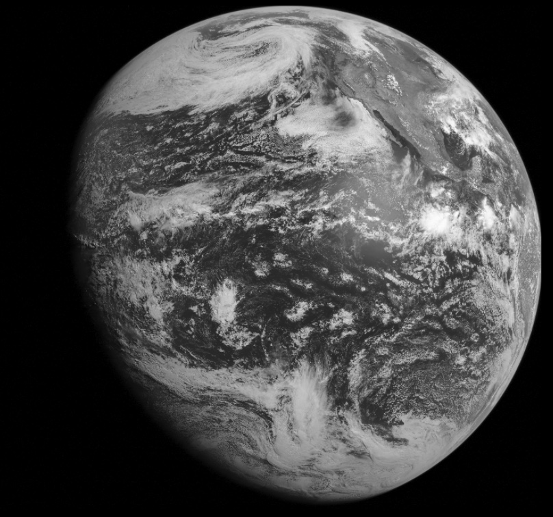
The above image was taken by the GOES-15 (West) satellite at 11AM (PDT), June 5th, 2017. At least that's what NASA would have you believe. But we don't have to take their word for it, we can check for yourself.

Verifying that satellite images are real is done by comparing them against the "ground truth" - i.e., the actual situation on the ground. Here I'm going to focus on the GOES satellites, particularly GOES-East and GOES-West. The process is:
  • Pick a Satellite with the best view of your region
  • Find out when it will take full-disk photos
  • Pick a day when there's some interesting clouds or contrails in the sky
  • At that time go outside and take lots of photos in every direction (over five minutes or so)
  • Wait for the full disk photo to be downloaded from the satellite and appear on the web site (about 35 to 40 minutes for GOES images)
  • Compare your photos with the satellite image.
#1 - Pick a satellite.  Here's a variety of satellites that give high resolution full-disk images:
Since I'm in California I'm going to use the GOES-West satellite, and get the images from the "Raw West" link, which goes to:  https://goo.gl/zZu2Gh (I've shortened the link, as it's an FTP site, the direct link is: ftp://goes.gsfc.nasa.gov/pub/goeswest/fulldisk/fullres/vis/). This gives a list of files like:


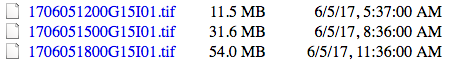
The latest file should be at the bottom. The filenames are in the date format YYMMDDHHMM then G15 for GOES-15 and I01 for the image type (visible). So 1706051800 is 2017-June-05 1800 UTC. Where 18:00 UTC is the time in UTC, and you will want to convert it to your local time. I use google for this, like:


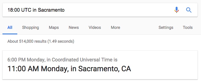
(Note both times say Monday, UTC might be a day ahead or behind the local date, depending on what time it is)

So, I took lots of images at around 11AM, then waited and download the 1800 UTC image. This is a TIF file, and not all programs can open it, so try different ones. Then you will probably want to increase the brightness if you can.

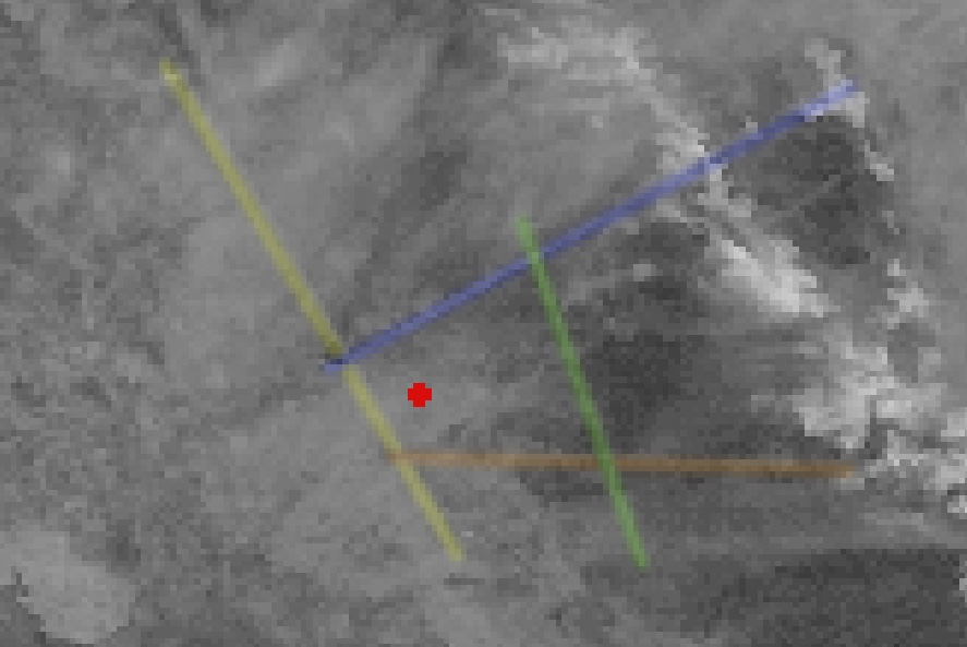
There's a variety of things you can compare, but probably the simplest is the cloud cover - and more specifically the airplane contrails that appear in the image. Here's a closer look at a region of California with some landmarks identified. This is simply a part of the above image.


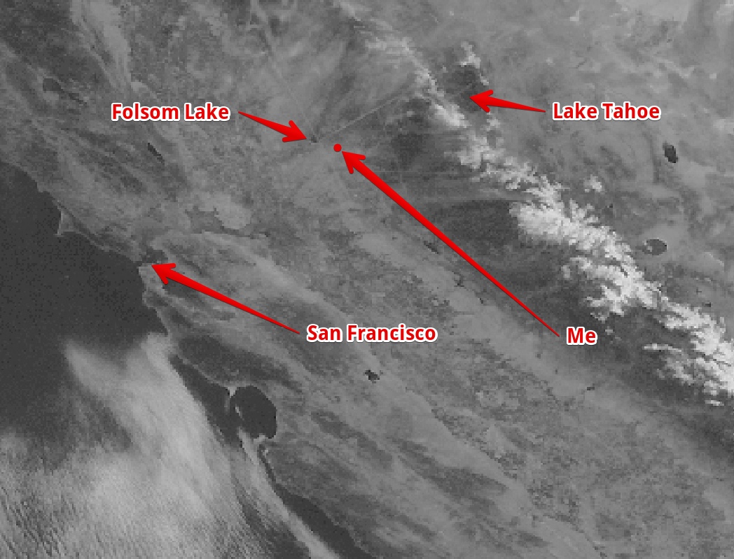
You can see there's a a few contrails there. Notably there's four that form a trapezoid shape around my location. Here I've color coded them:


If you are lucky you will also be able to get a MODIS image from about the same time. This can be helpful in interpreting what you are seeing, but is not strictly necessary:

https://worldview.earthdata.nasa.gov/?p=geographic&l=VIIRS_SNPP_CorrectedReflectance_TrueColor(hidden),MODIS_Aqua_CorrectedReflectance_TrueColor(hidden),MODIS_Terra_CorrectedReflectance_TrueColor,Reference_Labels(hidden),Reference_Features(hidden),Coastlines&t=2017-06-05&z=3&v=-122.90918176234946,37.48960532127974,-118.69043176234946,39.81650961815474


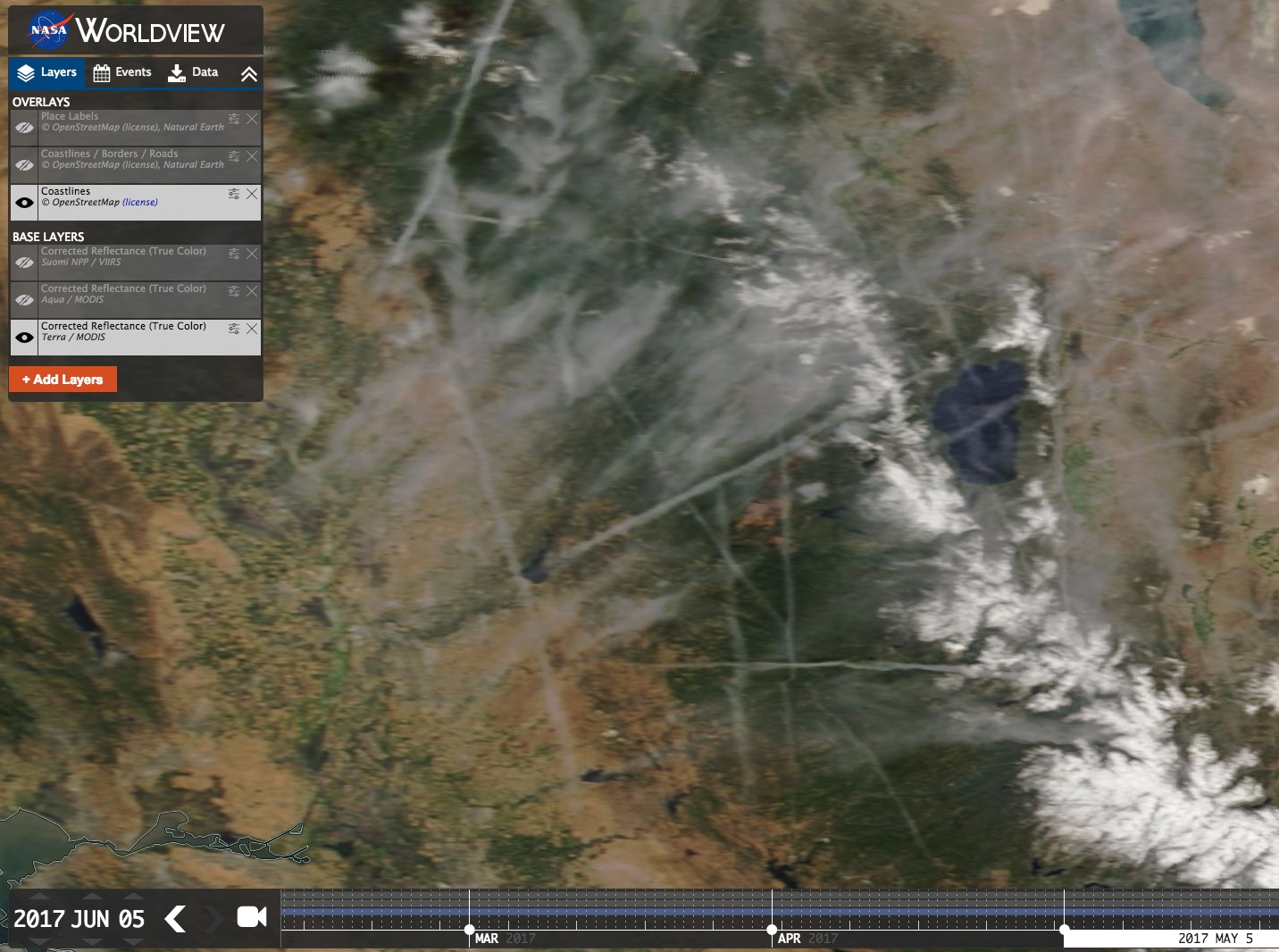
Then we just need to compare against the photos. It's best to use a wide angle lens, or if not, you can use the panorama mode on your camera/phone. Ideally you would capture a high resolution 360 degree image of the sky.

This is one I took, unfortunately a few minutes early:


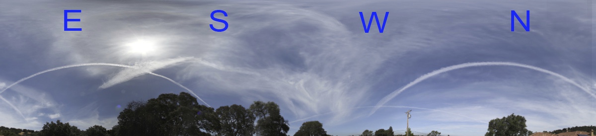
This makes the contrails look curved, but they are actually straight

Here's the view looking west at 17:56. I've indicated the blue and yellow contrails:


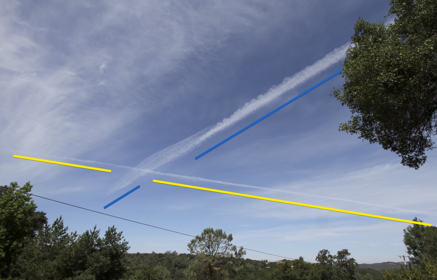
The images being a few minutes off means the contrails have moved. This shows the importance of getting the images as close as possible to the actual imaging time of the satellite.

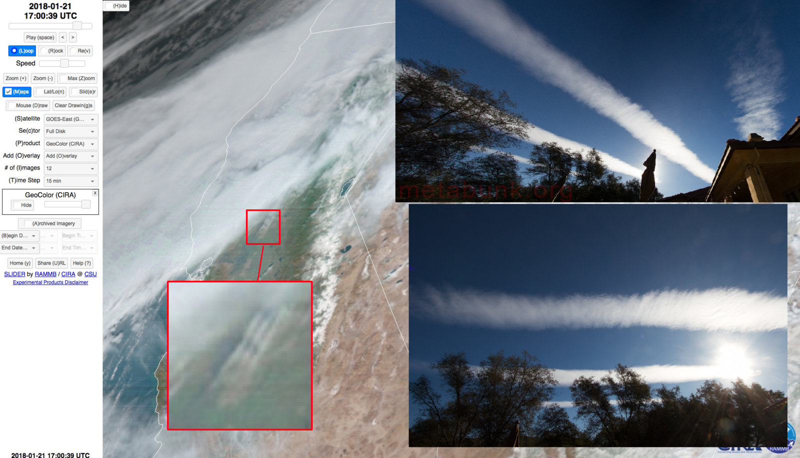
Here's the satellite image from January 21st, 2018, showing a brief large scale set of row clouds that allowed me to match up the GOES-16 image with what I saw over my house:


And here's an image from the Suomi NPP satellite, taken a few days ago over Guatemala:


(Note: when I say "me" or "my house" or "I" what I actually mean is: "some other person" or "their house" or "them".)
« Last Edit: June 05, 2018, 02:06:50 PM by Max_Almond »

Re: How to Prove Satellite Images are Real
« Reply #1 on: June 07, 2018, 03:15:03 PM »
Not sure why there hasn't been a response to this thread?  I was going to play FE on this one, but I got nothing to debunk
Quote from: SiDawg
Planes fall out of the sky all the time

*

Offline Tumeni

  • *
  • Posts: 3179
    • View Profile
Re: How to Prove Satellite Images are Real
« Reply #2 on: June 07, 2018, 05:25:57 PM »
Another way to prove same is to compare the output from two separate, independent satellites

=============================
Not Flat. Happy to prove this, if you ask me.
=============================

Nearly all flat earthers agree the earth is not a globe.

Nearly?

Re: How to Prove Satellite Images are Real
« Reply #3 on: June 11, 2018, 01:40:58 PM »
playing devil's advocate on behalf of the FE'ers that havent responded here.  I think what you have actually proved is that NASA and others are utilized ground based weather radar in order to generate these CGI satellite images.  makes sense, instead of constant guessing, just use the data you already have from the flat ground.  then project  that information onto the made up "ball".  brilliant NASA.
Quote from: SiDawg
Planes fall out of the sky all the time

Max_Almond

Re: How to Prove Satellite Images are Real
« Reply #4 on: June 11, 2018, 02:43:21 PM »
Exactly. Why not? It probably wouldn't cost that much or be that difficult to employ an army of computer programmers to fake these constantly beamed down images of earth so that they match the cloud and contrail and volcano activity that you can see over your own head.

And just because it makes no logical sense to do that - I mean, why keep telling us they're sending up new satellites if all that means is more and more work for themselves? - there's no reason why it can't be true.
« Last Edit: June 12, 2018, 11:44:55 AM by Max_Almond »

Re: How to Prove Satellite Images are Real
« Reply #5 on: June 11, 2018, 02:48:54 PM »
Exactly. Why not? It probably wouldn't cost that much or be that difficult to employ and army of computer programmers to fake these constantly beamed down images of earth so that they match the cloud and contrail and volcano activity that you can see over your own head.

And just because it makes no logical sense to do that - I mean, why keep telling us they're sending up new satellites if all that means is more and more work for themselves? - there's no reason why it can't be true.

NASA has to keep sending up "satellites" in order to keep justifying their budget and keep their conspiracy alive.  those rockets are not going to space, they are re-supply ration deliveries headed to the soldiers guarding the ice wall.

Follow the money...
« Last Edit: June 11, 2018, 02:50:57 PM by Round Eyes »
Quote from: SiDawg
Planes fall out of the sky all the time

Max_Almond

Re: How to Prove Satellite Images are Real
« Reply #6 on: June 11, 2018, 03:24:09 PM »
Same for the Japanese, I suppose. Imagine if they hadn't (made out they'd) superceded Himawari-8 - the population would have been up in arms!

*

Offline Tom Bishop

  • Zetetic Council Member
  • **
  • Posts: 10662
  • Flat Earth Believer
    • View Profile
Re: How to Prove Satellite Images are Real
« Reply #7 on: June 11, 2018, 03:32:06 PM »
Exactly. Why not? It probably wouldn't cost that much or be that difficult to employ and army of computer programmers to fake these constantly beamed down images of earth so that they match the cloud and contrail and volcano activity that you can see over your own head.

And just because it makes no logical sense to do that - I mean, why keep telling us they're sending up new satellites if all that means is more and more work for themselves? - there's no reason why it can't be true.

NASA has to keep sending up "satellites" in order to keep justifying their budget and keep their conspiracy alive.  those rockets are not going to space, they are re-supply ration deliveries headed to the soldiers guarding the ice wall.

Follow the money...

NASA's federal budget doesn't fully represent the $200 Billion a year satellite industry. There is another motive.

Re: How to Prove Satellite Images are Real
« Reply #8 on: June 11, 2018, 03:58:55 PM »
Exactly. Why not? It probably wouldn't cost that much or be that difficult to employ and army of computer programmers to fake these constantly beamed down images of earth so that they match the cloud and contrail and volcano activity that you can see over your own head.

And just because it makes no logical sense to do that - I mean, why keep telling us they're sending up new satellites if all that means is more and more work for themselves? - there's no reason why it can't be true.

NASA has to keep sending up "satellites" in order to keep justifying their budget and keep their conspiracy alive.  those rockets are not going to space, they are re-supply ration deliveries headed to the soldiers guarding the ice wall.

Follow the money...

NASA's federal budget doesn't fully represent the $200 Billion a year satellite industry. There is another motive.
Of which the launch part of that industry only makes up 5.4 Billion. Granted that's about 1/4 of what they get from the government, but it's also the amount of money spent on it WORLDWIDE, and not just to NASA.

https://www.statista.com/statistics/185977/distribution-of-the-worldwide-revenues-of-the-satellite-industry-by-sector/

Re: How to Prove Satellite Images are Real
« Reply #9 on: June 11, 2018, 04:26:27 PM »


NASA's federal budget doesn't fully represent the $200 Billion a year satellite industry. There is another motive.


Exactly Max.  NASA tells us it costs $10,000 for every pound we put into orbit....yeah, ok, i dont think so.  amateur rocket scientists can launch rockets for a tiny fraction of that cost.  NASA is the focal point of the logistics involved with the support of troops at the wall.  I bet if you did the math and figured out the true cost of launching a rocket and then calculate the cost it takes to support a remote army in an inhospitable environment like Antartica and i bet those costs added together would account for the majority of its budget.

Quote from: SiDawg
Planes fall out of the sky all the time

Re: How to Prove Satellite Images are Real
« Reply #10 on: June 11, 2018, 04:52:27 PM »


NASA's federal budget doesn't fully represent the $200 Billion a year satellite industry. There is another motive.


Exactly Max.  NASA tells us it costs $10,000 for every pound we put into orbit....yeah, ok, i dont think so.  amateur rocket scientists can launch rockets for a tiny fraction of that cost.  NASA is the focal point of the logistics involved with the support of troops at the wall.  I bet if you did the math and figured out the true cost of launching a rocket and then calculate the cost it takes to support a remote army in an inhospitable environment like Antartica and i bet those costs added together would account for the majority of its budget.
This is difficult to do, but I would argue that a rough estimate could be gained by looking at the cost of the Iraq war. From 2003-2010 the DoD says we spent $757.8 billion, or roughly $94.7 billion per year. We sent 130,000 people there at the start of the invasion, and at the end of this period in 2010 we saw about 50,000 still there. We'll go with a rough average of 85,000 there at any one time. This gives us our cost per soldier each year estimate at about $1.1 million. With NASA's budget being $19.3 billion in 2016, this would allow for about 17,000 troops stationed there at any one time. But recall they need to factor in the costs of all the graphic artists they employ, the fake launches, servicing whatever is providing sat TV and sat GPS as well, which I'm not sure how to even begin to calculate those costs. But there's your starting point. (I'd also be curious to see your source and costs for 'amateur rocket scientists' launching equipment into orbit for a 'tiny fraction of that cost' if you could.)

*

Offline Tumeni

  • *
  • Posts: 3179
    • View Profile
Re: How to Prove Satellite Images are Real
« Reply #11 on: June 11, 2018, 05:18:29 PM »
NASA has to keep sending up "satellites" in order to keep justifying their budget and keep their conspiracy alive.  those rockets are not going to space, they are re-supply ration deliveries headed to the soldiers guarding the ice wall

Most of the satellite launches, and most of the satellites already up there, are not actually NASA satellites, so ....
=============================
Not Flat. Happy to prove this, if you ask me.
=============================

Nearly all flat earthers agree the earth is not a globe.

Nearly?

Re: How to Prove Satellite Images are Real
« Reply #12 on: June 11, 2018, 05:31:52 PM »


NASA's federal budget doesn't fully represent the $200 Billion a year satellite industry. There is another motive.


Exactly Max.  NASA tells us it costs $10,000 for every pound we put into orbit....yeah, ok, i dont think so.  amateur rocket scientists can launch rockets for a tiny fraction of that cost.  NASA is the focal point of the logistics involved with the support of troops at the wall.  I bet if you did the math and figured out the true cost of launching a rocket and then calculate the cost it takes to support a remote army in an inhospitable environment like Antartica and i bet those costs added together would account for the majority of its budget.
This is difficult to do, but I would argue that a rough estimate could be gained by looking at the cost of the Iraq war. From 2003-2010 the DoD says we spent $757.8 billion, or roughly $94.7 billion per year. We sent 130,000 people there at the start of the invasion, and at the end of this period in 2010 we saw about 50,000 still there. We'll go with a rough average of 85,000 there at any one time. This gives us our cost per soldier each year estimate at about $1.1 million. With NASA's budget being $19.3 billion in 2016, this would allow for about 17,000 troops stationed there at any one time. But recall they need to factor in the costs of all the graphic artists they employ, the fake launches, servicing whatever is providing sat TV and sat GPS as well, which I'm not sure how to even begin to calculate those costs. But there's your starting point. (I'd also be curious to see your source and costs for 'amateur rocket scientists' launching equipment into orbit for a 'tiny fraction of that cost' if you could.)

the Zenit was roughly $800/lb for low orbit and Musk has stated he thinks he can get to $500/lb.  NASA isnt putting rockets into orbit, its not possible, so the math they provide publicly is wrong.  They have been in the rocket game a long time, so a reasonable  they can at least do it as cheaply as the Zenit (or less).  thats a discrpency of at least $9,200 for every pound of material they "put into space".  so where is the rest of the money going...support for the international troops at the ice wall and for funding of the high altittude airplanes running around the clock, or as you Round Earthers call "satellites"

they have to keep launching rockets, its a huge cash cow for them.  imagine the cash flow they are going to have when we start "going" to Mars.  wow.

nice work on funding per soldier, i would add a 150% markup based on the cold conditions, and i am sure the extra paid to keep their silence when they return home.  the number of soldiers sounds low based on the miles of wall they would protecting.  i would estimate 20% of NASA budget for the CGI/PR machine.  But also, NASA isnt the only one supporting troops.  It could easily by 40,000 troops stationed down there, but there are a lot of "space" agencies kicking in money. 
« Last Edit: June 11, 2018, 05:37:08 PM by Round Eyes »
Quote from: SiDawg
Planes fall out of the sky all the time

Re: How to Prove Satellite Images are Real
« Reply #13 on: June 11, 2018, 05:32:26 PM »
NASA has to keep sending up "satellites" in order to keep justifying their budget and keep their conspiracy alive.  those rockets are not going to space, they are re-supply ration deliveries headed to the soldiers guarding the ice wall

Most of the satellite launches, and most of the satellites already up there, are not actually NASA satellites, so ....

its all one big pool of money...and of course, as with everything else, NASA/USA is putting in more than their fair share of money
« Last Edit: June 11, 2018, 05:37:39 PM by Round Eyes »
Quote from: SiDawg
Planes fall out of the sky all the time

Re: How to Prove Satellite Images are Real
« Reply #14 on: June 11, 2018, 05:56:44 PM »


NASA's federal budget doesn't fully represent the $200 Billion a year satellite industry. There is another motive.


Exactly Max.  NASA tells us it costs $10,000 for every pound we put into orbit....yeah, ok, i dont think so.  amateur rocket scientists can launch rockets for a tiny fraction of that cost.  NASA is the focal point of the logistics involved with the support of troops at the wall.  I bet if you did the math and figured out the true cost of launching a rocket and then calculate the cost it takes to support a remote army in an inhospitable environment like Antartica and i bet those costs added together would account for the majority of its budget.
This is difficult to do, but I would argue that a rough estimate could be gained by looking at the cost of the Iraq war. From 2003-2010 the DoD says we spent $757.8 billion, or roughly $94.7 billion per year. We sent 130,000 people there at the start of the invasion, and at the end of this period in 2010 we saw about 50,000 still there. We'll go with a rough average of 85,000 there at any one time. This gives us our cost per soldier each year estimate at about $1.1 million. With NASA's budget being $19.3 billion in 2016, this would allow for about 17,000 troops stationed there at any one time. But recall they need to factor in the costs of all the graphic artists they employ, the fake launches, servicing whatever is providing sat TV and sat GPS as well, which I'm not sure how to even begin to calculate those costs. But there's your starting point. (I'd also be curious to see your source and costs for 'amateur rocket scientists' launching equipment into orbit for a 'tiny fraction of that cost' if you could.)

the Zenit was roughly $800/lb for low orbit and Musk has stated he thinks he can get to $500/lb.  NASA isnt putting rockets into orbit, its not possible, so the math they provide publicly is wrong.  They have been in the rocket game a long time, so a reasonable  they can at least do it as cheaply as the Zenit (or less).  thats a discrpency of at least $9,200 for every pound of material they "put into space".  so where is the rest of the money going...support for the international troops at the ice wall and for funding of the high altittude airplanes running around the clock, or as you Round Earthers call "satellites"
Again, do you have a source for any of these numbers? I see an article from 2008 (10 YEARS ago) that gives NASA launches at $10k/pound. NASA no longer directly sends things into space though according to another article. The lowest I see is a 2017 article that gives SpaceX a cost of $1250/pound as the lowest amount. That article DOES also cite Rocket Labs as still being $10k/pound, however it has significant differences to how SpaceX is launching theirs, including a very different weight limit.

Re: How to Prove Satellite Images are Real
« Reply #15 on: June 11, 2018, 07:39:56 PM »

Again, do you have a source for any of these numbers? I see an article from 2008 (10 YEARS ago) that gives NASA launches at $10k/pound. NASA no longer directly sends things into space though according to another article. The lowest I see is a 2017 article that gives SpaceX a cost of $1250/pound as the lowest amount. That article DOES also cite Rocket Labs as still being $10k/pound, however it has significant differences to how SpaceX is launching theirs, including a very different weight limit.

plenty of sources on the Zenit costs per pound, readily available on the line.  We can use your numbers for spacex if you like, not that much different in the comparing.  but you think a company (spacex) is able to completly bypass NASA that has been around 60+ years this quickly and cut costs from $10k to 1.2k?  thats naive.

  why do we even care about the $10k/lb NASA number, those are obviously fabricated.  no point in even arguing about that.
« Last Edit: June 11, 2018, 07:43:16 PM by Round Eyes »
Quote from: SiDawg
Planes fall out of the sky all the time

Re: How to Prove Satellite Images are Real
« Reply #16 on: June 11, 2018, 09:15:01 PM »

Again, do you have a source for any of these numbers? I see an article from 2008 (10 YEARS ago) that gives NASA launches at $10k/pound. NASA no longer directly sends things into space though according to another article. The lowest I see is a 2017 article that gives SpaceX a cost of $1250/pound as the lowest amount. That article DOES also cite Rocket Labs as still being $10k/pound, however it has significant differences to how SpaceX is launching theirs, including a very different weight limit.

plenty of sources on the Zenit costs per pound, readily available on the line.  We can use your numbers for spacex if you like, not that much different in the comparing.  but you think a company (spacex) is able to completly bypass NASA that has been around 60+ years this quickly and cut costs from $10k to 1.2k?  thats naive.

  why do we even care about the $10k/lb NASA number, those are obviously fabricated.  no point in even arguing about that.
"Plenty of sources" No, post one, it's your claim. I haven't found a single source stating that low. Also remember NASA didn't upgrade their shuttle tech for 20ish years. So yeah, I'd say 30 years of development in many areas can easily result in a reduction of 90+%, just look at what computers did in 30 years.

Re: How to Prove Satellite Images are Real
« Reply #17 on: June 12, 2018, 02:29:02 AM »

Again, do you have a source for any of these numbers? I see an article from 2008 (10 YEARS ago) that gives NASA launches at $10k/pound. NASA no longer directly sends things into space though according to another article. The lowest I see is a 2017 article that gives SpaceX a cost of $1250/pound as the lowest amount. That article DOES also cite Rocket Labs as still being $10k/pound, however it has significant differences to how SpaceX is launching theirs, including a very different weight limit.

plenty of sources on the Zenit costs per pound, readily available on the line.  We can use your numbers for spacex if you like, not that much different in the comparing.  but you think a company (spacex) is able to completly bypass NASA that has been around 60+ years this quickly and cut costs from $10k to 1.2k?  thats naive.

  why do we even care about the $10k/lb NASA number, those are obviously fabricated.  no point in even arguing about that.
"Plenty of sources" No, post one, it's your claim. I haven't found a single source stating that low. Also remember NASA didn't upgrade their shuttle tech for 20ish years. So yeah, I'd say 30 years of development in many areas can easily result in a reduction of 90+%, just look at what computers did in 30 years.

You are the one questioning my numbers, which btw are almost the same as the number you are using ($800 compared to $1,200 compared to $10k)   You can find it, it took me 2 minutes, if it really matters so much to you.  Even using your numbers, it doesn't matter, still proves my point.  NASA inflating costs 8-12x on paper... Why?  We know the reason.  This has all been discussed.
Quote from: SiDawg
Planes fall out of the sky all the time

Re: How to Prove Satellite Images are Real
« Reply #18 on: June 12, 2018, 03:12:39 AM »

Again, do you have a source for any of these numbers? I see an article from 2008 (10 YEARS ago) that gives NASA launches at $10k/pound. NASA no longer directly sends things into space though according to another article. The lowest I see is a 2017 article that gives SpaceX a cost of $1250/pound as the lowest amount. That article DOES also cite Rocket Labs as still being $10k/pound, however it has significant differences to how SpaceX is launching theirs, including a very different weight limit.

plenty of sources on the Zenit costs per pound, readily available on the line.  We can use your numbers for spacex if you like, not that much different in the comparing.  but you think a company (spacex) is able to completly bypass NASA that has been around 60+ years this quickly and cut costs from $10k to 1.2k?  thats naive.

  why do we even care about the $10k/lb NASA number, those are obviously fabricated.  no point in even arguing about that.
"Plenty of sources" No, post one, it's your claim. I haven't found a single source stating that low. Also remember NASA didn't upgrade their shuttle tech for 20ish years. So yeah, I'd say 30 years of development in many areas can easily result in a reduction of 90+%, just look at what computers did in 30 years.

You are the one questioning my numbers, which btw are almost the same as the number you are using ($800 compared to $1,200 compared to $10k)   You can find it, it took me 2 minutes, if it really matters so much to you.  Even using your numbers, it doesn't matter, still proves my point.  NASA inflating costs 8-12x on paper... Why?  We know the reason.  This has all been discussed.
You're presenting your numbers without a source. It's not on me to provide one. Also, once again, NASA's figures are 30 years old. No wonder it costed so much more per pound. They don't even technically launch their own shuttles anymore.

No, we have your claims, once again without evidence. Care to provide any?

Re: How to Prove Satellite Images are Real
« Reply #19 on: June 12, 2018, 01:20:28 PM »

You're presenting your numbers without a source. It's not on me to provide one. Also, once again, NASA's figures are 30 years old. No wonder it costed so much more per pound. They don't even technically launch their own shuttles anymore.

No, we have your claims, once again without evidence. Care to provide any?

NASA figures are not 30 years old, thats a lie you are saying.  straight off their website, its says "TODAY, it costs $10k per lb"....unless you are saying NASA created this webpage 30 years ago and hasnt updated it???

link (source):  https://www.nasa.gov/centers/marshall/news/background/facts/astp.html

who said anything about shuttles?  are you ignorant to the fact that NASA has many different rockets they use to launch payloads?  are you going to continue to provide false facts to try and support your sides of the argument?  its all very clear that NASA is lying

here is a link to the launch schedule by NASA, many of them are there own rockets:  https://www.nasa.gov/launchschedule/

try to verify your statements before posting to avoid these types of errors in the future.

« Last Edit: June 12, 2018, 01:28:41 PM by Round Eyes »
Quote from: SiDawg
Planes fall out of the sky all the time