The Sisters one is definitely the best, by far, though the others work too.
I also have a nice shot of the front range of the Rockies, with about thirty peaks in it, which also illustrates the point:
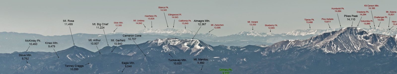
(right-click and open in new tab to see it full-size)
My mistake on the Pyramid Peak elevation: I'd taken it from peakfinder, but used NAVD88 for the others, as Tom helpfully highlighted:
There are a wide range of elevation estimates depending on the source you consult.
For example, Peak Finder says Pyramid Peak Colorado is 13780 ft, and its Wikipedia page for Pyramid Peak Colorado says "Elevation: 14,025′".
A possible difference of 245 feet depending on the source.
Peakfinder currently has Pyramid Peak at 13,930 feet - but Tom was taking the elevation of an observer point near Pyramid Peak, not the peak itself:

I have found that the summit elevations on peakfinder don't seem as reliable as expected, and are often quite different to the NAVD88 elevations, and other more well-used sources. Reason being: information on peakfinder is from openstreetmap.org, which is user-created and editable, and more prone to error.
I have now corrected the error at openstreetmap, so hopefully that will be reflected in peakfinder too.
In any case, either one of those elevations proves the point.
I've also fixed it in the posts and images above. Thanks again for pointing that out.