Show Posts

This section allows you to view all posts made by this member. Note that you can only see posts made in areas you currently have access to.


Messages - Nirmala

Pages: < Back  1 2 [3] 4 5 ... 12  Next >
41
Flat Earth Theory / Re: The length of the day on a flat earth
« on: April 30, 2017, 03:01:19 PM »
I addressed how that is explained on that map earlier in this thread when it was brought up. I don't even use that map as my main go-to flat earth map, anyway. I typically use the one where Antarctica is a continent.

It seems to me that you use both maps at different points. Which model do you personally actually believe in: the unipolar flat earth with an ice ring around it, or a bipolar flat earth with Anarctica as a separate continent that can be circumnavigated? And if the latter, then what is beyond the edge of the bipolar flat map? Another ice ring? An infinite ocean in perpetual darkness? Or are you undecided about which model is true?

I know I have asked these questions on another thread, but I am still waiting for an answer. It seems strange for someone to argue from a unipolar model and a bipolar model in the same thread as they often contradict each other, especially on a topic like this thread's topic.

42
Flat Earth Community / Re: Feeling the rotation of the moon?
« on: April 30, 2017, 02:45:00 PM »
We all know that we are told that we don't feel the rotation of the earth because of relativity and the atmosphere moving due to gravity etc. The thought then hit me; why didn't he astronauts feel the rotation of the moon? What is the explanation? Is it because there is no gravity or atmosphere? The moon rotates at 2288 miles an hour. That's over a thousand miles faster than the earth. I tried to look for an answer but couldn't really find anything. Anyone have an explanation for this, or came across one?

There is gravity on the moon, just much less than here on earth, so that would hold them and all of the moon rocks, dust etc in place. And there is no atmosphere on the moon, so no "air" was moving either with the astronauts or around them.

Also, the speed you quote is the speed that the moon travels in its revolution around the earth, not in its rotation. The moon actually rotates just once every 27.322 days, so it is rotating at a much slower speed.

43
Another question arose on a different thread. If the sun is circling the north pole in the northern summer, then location B on the map would be in perpetual darkness just like the south pole, and in fact would be in darkness for even longer each year. The reverse would be true in the northern winter: the area above the north pole would be in perpetual darkness.

If this was true, then it would seem that those areas would experience the formation of sea ice during the respective periods of total darkness lasting 6 months or more. Since when has there been any sea ice along the Tropic of Cancer or the Tropic of Capricorn? This is another unexplained flaw in the bipolar map that would still be a flaw no matter where you place the continents on the map.

44
http://wiki.tfes.org/Atmolayer_Lip_Hypothesis

Actually the center of Antarctica is an area of high pressure: http://www.antarctica.gov.au/about-antarctica/environment/weather

And the idea in the Wiki that the area around the earth gradually drops to absolute zero is hard to fathom. The atmosphere would turn to liquid long before absolute zero, and so that liquid air would either pool on the surface or possibly flow back towards the center and also outwards. I don't think a giant lake of liquid air could hold in our atmosphere as the wiki entry posits. And since cold air is much heavier than warm air, it also seems that long before the air was at a low enough temperature to liquefy, it would tend to flow under the hotter air in the center of our earth, which again would cool the area we live on drastically.

And I am curious why you would refer to the Wiki when it clearly is suggesting that the earth fits the unipolar model. Do you personally believe that Antarctica is a continent or an ice ring around the earth? Or are you undecided, so you refer to both models as needed to answer questions?

And how would you answer this question in regards to a bipolar model? What lies beyond the area of the flat earth that we live on in the bipolar model? More ocean? A different ice ring? Why have humans not traveled beyond the edge in the bipolar model if there is no ice ring patrolled by armed guards stopping them? In the bipolar model, why are there warm areas near the edge of the earth and cold areas (the poles) surrounded by warm areas? In the globe earth, there is one central band of warmer temps around the equator that then gradually cools as one approaches the poles. How do the cold areas form in the middle of the large circular warm areas that would seem to exist on the bipolar map if the sun circles the poles as you described in another thread. And why wouldn't the oceans on the side of the south pole that is farther away from the the north pole than the south pole itself freeze in the southern winter when the sun gets nowhere near them. The area around the south pole tends to form more ice in the southern winter, so why wouldn't the area beyond the south pole which is also in constant darkness freeze during the southern winter?

As usual, the flat earth model raises many more questions than it ever answers.

45
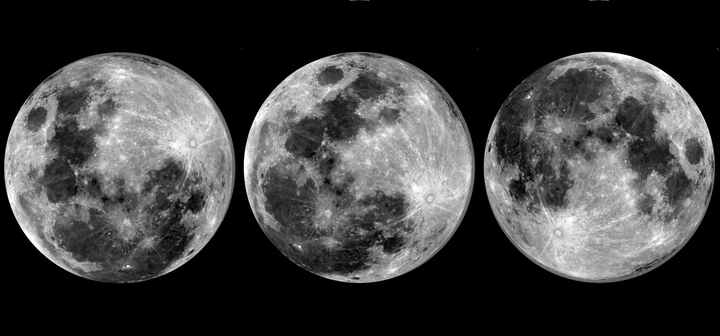
Flat Earth Theory / Why does the moon appear upside down in the south?
« on: April 28, 2017, 07:47:49 PM »
In the Wiki it says:

"Why does the moon look the same to everyone?

Q: Why does the moon and the phases look the same to everyone one earth regardless of where they are?

A: It doesn't. The phase you see varies depending on your location on earth. In FET this is explained by the different observers standing on either side of the moon. On one side it is right-side up, and on the other side it is upside down.

Imagine a green arrow suspended horizontally above your head pointing to the North. Standing 50 feet to the South of the arrow it is pointing "downwards" towards the Northern horizon. Standing 50 feet to the North of the arrow, looking back at it, it points "upwards" above your head to the North. The arrow flip-flops, pointing down or away from the horizon depending on which side you stand.
"

But let's say the top half of a 3D tubular arrow overhead was red and the bottom half was green (see the attached image of an arrow). Then no matter where I stood on a flat earth, I would still see the top half as red and the bottom half as green, even if the arrow seemed to be pointing up over my head instead of down towards the ground. I would still always see the top half of the arrow as being red. Or better yet, imagine a ball in the air overhead where the top half was red and the bottom half was green. Again, I would always see the top half of the ball as red and the bottom as green no matter which side of the ball I was on on a flat earth. Something like this but with green instead of white:


Now imagine a ball with four colors; red on top and green on the bottom on one side and blue on top and yellow on the bottom on the other side. Something like this but with only four bands of color:

As I moved around on the flat earth I should be able to see the red/green side from one direction and the blue-yellow side from the opposite direction

This does not happen when I view the moon. Instead the top and bottom halves switch in the southern hemisphere, and furthermore, there is not another side of the moon (equivalent to the blue/yellow side of the ball) with distinct features. The same features still appear but upside down:


Can anyone explain why the top and bottom of the moon switch places and why no one ever sees the other side of the moon in the flat earth model?

46
Flat Earth Theory / Re: Upcoming Solar Eclipse in USA
« on: April 28, 2017, 07:34:45 PM »
Why do solar eclipses only happen during the new moon? How are the motion of the moon and the motion of this shadow object so exactly synchronized that the obscuring of the sun only happens when the moon is exactly at the new moon phase? And same question for the lunar eclipse? As far as I can tell, in the Wiki, it says the phases of the moon are caused by the height of the moon above the earth. Why would that limit or affect when the shadow object could be in the way of the sun?


47
Flat Earth Theory / Re: Upcoming Solar Eclipse in USA
« on: April 28, 2017, 03:29:11 PM »
If the "dark object" also causes the lunar eclipses, then why does it not block out the stars in the sky surrounding the moon as it moves into position in front of the moon?

Apparently, this object only orbits the sun, shrouded in the sun's light in order to remain invisble to laymen eyes.

Is funny that this object is still a secret since we have in our power infrared telescopes that are able to take termal images of the celestial bodies.

So a lunar eclipse happens when the shadow object is lined up between the sun and the moon as described in the wiki. That would seem to make it pretty easy to know where to look for it in the sky during a lunar eclipse...just look along a line from the sun to the moon. So that would not require a survey of the entire sky, but a very small portion of it.

48
Flat Earth Community / Re: Boy, NASA sure has a lot of pics
« on: April 28, 2017, 03:46:16 AM »
Cassini has sent back a total of 383,731 images. And I thought there were a lot of pictures from the Apollo mission. Someone should tell NASA that they are overdoing the fake pictures from space, as clearly they only needed 350,000 or so to make the mission look real ;)

https://saturn.jpl.nasa.gov/galleries/raw-images/

49
Flat Earth Theory / Re: Upcoming Solar Eclipse in USA
« on: April 27, 2017, 06:43:07 PM »
If the "dark object" also causes the lunar eclipses, then why does it not block out the stars in the sky surrounding the moon as it moves into position in front of the moon?

50
Flat Earth Theory / Re: Distances
« on: April 27, 2017, 03:26:11 PM »
according to the proposed map has a distance of 8,886km.
Where did you get that number from? It's flat-out incorrect.

This number is 241% of the actual value. How do you explain that?  ;)
We don't. The distances are identical between the models.

So, if the distances are identical between the models, then how do you explain that the flat earth maps show the distance between Sydney and Santiago to be much further than the distance on the actual flight path that is flown by commercial aircraft on that route:
https://www.metabunk.org/flat-earth-theory-debunked-by-short-flights-qf27-qf28-from-australia-to-south-america.t6483/

Can you show us a representation of the flat earth where the distances between major airports is represented as being consistent with the distances shown on a globe, and also as documented on flightaware.com? You say the distances are identical. How does that work on a flat earth? The distances do not work on any flat earth map that has been posted on this website. Is there some other geometry involved as you suggested on another thread? If so, how does it work to calculate the identical distances you claim?

51
Nirmala,

Look at the words "Ephemeris" and "ephemerides" in the sources you provided on the previous page.

https://en.wikipedia.org/wiki/Ephemeris

Quote
Modern ephemerides are often computed electronically from mathematical models of the motion of astronomical objects and the Earth. Even though the calculation of these tables was one of the first applications of mechanical computers, printed ephemerides are still produced, as they are useful when computational devices are not available.

Yes, I get it that most of the data in these publications and on the timeanddate.com website are calculated. However, the links I offered explained that those calculations are based on observations taken over hundreds of years and the calculations are also refined when new technology allowed more accurate observations. Both the observations and calculations have proven reliable enough to have been used for those hundreds of years to navigate the oceans and less populated areas of the earth. If they were inaccurate, they would have been blamed by now for thousands if not hundreds of thousands of deaths over the centuries from shipwrecks and people lost in the wilderness. But instead the publications have been continuously published for 250 years and trusted by both navigators and astronomers who want to know when they can make their observations to avoid disasters at sea or when using extremely expensive telescopes where every minute of available time to make observations was and is considered too valuable to waste by looking in the wrong place at the wrong time. Computers have taken over for most applications from the paper publications, but the computations are the same ones used for centuries, and the results are accurate both when published on paper and when performed by a computer program.

I trust a collected body of knowledge (both observed and calculated) with that kind of track record, and yet you seem to not trust it, even when it also is used every day by people who simply need to know what time of the day it is somewhere else in the world, and/or what time of the day to head down to the beach to watch the sunset.

This is similar to our discussion about flight times. Airlines and air passengers all over the world trust the published schedules to give an accurate estimate of the time their flights will take, and the flightaware.com website collects and provides the actual flight data,,yet you seem to think there is no data. Although actually, I do not know what you think of the flightaware.com website I provided since you simply stopped participating on that thread. I did discover that if you simply register for free on their site, you can then access four months of recent flight data for any commercial flight that connects two airports on this planet based on the over 100,000 commercial flights completed each day. That all adds up to millions of data points documenting the times and therefore distances between those points with enough average accuracy to completely debunk all of the flat earth maps presented so far.

I don't know if you are suspicious of all outside information to an extreme degree, or if you simply feel threatened when there is overwhelming evidence that refutes your belief system. I also have considered that you simply post on here to see what kind of reaction you can get. You obviously do not owe me or anyone else an explanation, but I do find you unusually resistant to any evidence or even the invitation to conduct your own observations, including one that only requires you to step outside with a long straight stick. And yet, in another post, you offer to allow yourself to be sent up in a high altitude balloon and also promise to report back honestly on what you see. I have my own contradictions and hypocrisies to answer for in life, so I will leave you to yours.

52
This was also explored on another thread starting with this post: http://forum.tfes.org/index.php?topic=5888.msg113568#msg113568

Several specific flights are completed in impossibly short times also if referring to a flat earth map: https://www.metabunk.org/flat-earth-theory-debunked-by-short-flights-qf27-qf28-from-australia-to-south-america.t6483/

Interesting.  Doesn't seem like you ever got a response that was able to explain it.  I'm honestly trying to keep an open mind about this stuff and listen to what these flat-earthers have to say but its really hard when they just deflect or ignore every argument or they just resort to personal attacks.

Yes, and they will sometimes engage with you up to a point as Tom Bishop did in the other thread, and then suddenly when you provide the data they have requested (or perhaps when you ask a question they really cannot answer), they stop responding to the thread altogether. I find that I can enjoy exercising my mind on here, but I do not expect to get anywhere really in terms of either understanding how the flat earth model is supposed to be possible, or in convincing anyone else to change their mind. Some of the round earth people discussing things on here are doing so because they hope to affect people who are new to the flat earth theory, when they may still be open to reason and logic.

53
This was also explored on another thread starting with this post: http://forum.tfes.org/index.php?topic=5888.msg113568#msg113568

Several specific flights are completed in impossibly short times also if referring to a flat earth map: https://www.metabunk.org/flat-earth-theory-debunked-by-short-flights-qf27-qf28-from-australia-to-south-america.t6483/

54
Flat Earth Theory / Re: Distances
« on: April 26, 2017, 11:53:29 PM »
On another site, someone referenced some flat earth maps where the continents do appear the correct shape and size such as this one:


However, on these maps, the lines of longitude are not correct (i.e. Perth appears to be on the same line of longitude as Korea instead of Indonesia), and furthermore the documented flight times between major cities in the southern hemisphere become even more impossible as explored in more depth in another thread starting with this post: http://forum.tfes.org/index.php?topic=5888.msg113568#msg113568

55
Flat Earth Theory / Re: The length of the day on a flat earth
« on: April 26, 2017, 03:24:49 PM »
I addressed how that is explained on that map earlier in this thread when it was brought up. I don't even use that map as my main go-to flat earth map, anyway. I typically use the one where Antarctica is a continent.
Your so-called explanations were refuted.

And what is this map you prefer to use? could you show it?

Similar problems with the areas of daylight and the path of the sun on the alternative bipolar map Tom Bishop is referring to are explored on these threads:
http://forum.tfes.org/index.php?topic=6083.0
http://forum.tfes.org/index.php?topic=6072.0

56
I just realized that there is an even more ridiculously impossible pattern of daylight on the bipolar map and posted about it here:
http://forum.tfes.org/index.php?topic=6072.msg115532#msg115532

In short, on Dec. 21st, if the sun circles the south pole of the bipolar map, then at certain times of day, the entire northern hemisphere would be in darkness as the sun would be on the other side of the south pole from all land masses in the north (position B on the attached map). However, it is never simultaneously dark in the entire northern hemisphere, even in the depths of winter, so the bipolar map is inherently incorrect.

57
The flip side is also true. All of these same problems appear in the Southern Hemisphere when the sun circles the north pole in the bipolar model on June 21st.

And to top it all off, if the sun does not light up the north pole on Dec.21st at position A, then most of the west coast of America, and Japan and the Koreas would all be in a constant 24 hours of darkness on Dec. 21st. Again if the sunlight does not reach the north pole, then the same north/south dimensions of sunlight would mean these areas never receive daylight in the depth of winter as the sun moves along the path of the tropic of Capricorn as represented in the bipolar map. After all, Alaska is farther from the equator on this map than the north pole!

Now it has been said that the bipolar map is just an approximation and does not really represent the surface of the earth. But in order for the problem with all areas north of the equator receiving no light at position B to not occur, there would need to be areas of the northern hemisphere on the opposite side of Antarctica along with the sun at position B, so that as the sun reached position B it would still light up some areas of the northern hemisphere (it is always daylight somewhere in the northern hemisphere during the entire day on Dec. 21st...Anchorage, Reykjavik, Stockholm, Moscow and the Kamchatka Peninsula in northeast Russia all receive several hours of daylight on Dec. 21st, just at different times of the day.). Conversely, you would also need to put some land masses in the Southern Hemisphere on the opposite side of the north pole to take care of the daylight patterns in the south in June. There is no way to have the land masses in the north be located on both sides of the south pole and the land masses in the south be on both sides of the north pole, and still have all of the northern hemisphere continents be in the northern hemisphere, and also still have all of the southern hemisphere continents be in the south.....at least not on a bipolar flat earth map.

If you disagree, just show us how the map would look so that some areas in the north were in daylight when the sun is in position B. If you claim the area lit up by the sun in position B changes enough to light up some areas in the north due to changes in the height of the sun or the properties of the atmosphere, then those changes would mean that the area of daylight would have to also be lighting up the entire southern hemisphere, and also many of the areas in the north that are illuminated when the sun is at position A. Neither of those could be true, as it is never daylight simultaneously in the entire southern hemisphere. Also position B is 12 hours or so ahead or behind of position A and there are no areas in the north where daylight lasts more than 12 hours on Dec. 21st, and no areas in the north receive two separate periods of daylight in a single day.

It is easy to arrange the continents on a globe to account for observed patterns of daylight, which is why the areas of daylight on the globe appear just as they are predicted to and there are none of these insurmountable discrepancies in how daylight comes and goes that the flat earth model creates, no matter what flat earth map is referenced.

58
I look at the bipolar map as shown in the attachment below, and if I imagine the sun making a circle around the south pole as it is proposed that it does in the winter in the bipolar model described further up in this thread, there is a point on Dec. 21st when the sun is on the opposite side of the south pole from all of the continents in the northern hemisphere. At that distance, and again according to this model where the sun's light only reaches a certain distance on the flat earth (as described by Tom Bishop: "There is another mechanism which pushes the sun lower than it actually is, and limits its total visibility, and is a separate topic from this thread, and which there is evidence for. If this mechanism did not exist day and night could not exist, and the sun would be at all times above the surface of the earth."), then it would seem that none of the light would reach the northern hemisphere. Again in circling the south pole, the sun would be on the other side of the pole from all of the continents in the north, as shown in position B for at least part of every 24 hour day/night cycle.

This would result in the entire northern hemisphere being dark at the same time. That never happens even in the dead of winter. It is dark at the north pole for months at a time, but if you plot the positions of the sun as it circles the south pole, then at its closest position to the north pole, it would be at point A in the version of the map that is attached below. At its furthest position from the north pole it would be at position B, again in the attached image.

If at point A, the north pole is in total darkness, then at point B, all of the northern hemisphere (and even actually most of the land masses in the southern hemisphere would all be in darkness at the same time. This does not ever happen. It is never nighttime in the entire northern hemisphere at the same time.

To check this compare the distance from point A to the north pole, with the distances from all of the continents to point B. If the sun at point A does not light up the north pole, then the sun at point B would not light up most of the land masses on earth with the exception of the southern tips of South America, Africa and Australia. Everything else would be dark at that time of the day.

When has it ever been dark at the same time of the day in every city of North America, Europe, Asia and northern Africa and northern South America? Really? Nighttime in Honolulu, Los Angeles, New York, London, Paris, Cairo, New Delhi, Bangkok, Beijing, Tokyo and everywhere in between all at the same moment in time? That simply does not happen, ever. These cities span 18 time zones! When is it ever dark across 18 time zones at the temperate latitudes and also at the equator?

There is no path of the sun over a bipolar flat earth that can match the simplest patterns of daylight we observe every day in the winter in the northern hemisphere, where it is always daylight somewhere in the northern hemisphere, and is never simultaneously dark everywhere above the equator.

59
Flat Earth Theory / Re: sun rising below the clouds
« on: April 25, 2017, 09:58:11 PM »
Here is a video showing the sun reappear...

Looks more like a video of a MacBook screen and then an iPhone screen.

The video within the video is a live video feed of the camera in the drone. Starting at about 3:10 in the video, he alternates between showing us the live video feed from the drone and the actual view of the sunset where he conducted the experiment to verify that the two views are consistent, at least until the drone climbs up to 1000 feet and shows the sun above the horizon while the direct view is still showing it as below the horizon.

Pilots do this kind of thing in their airplanes for fun: http://www.flyingmag.com/technique/tip-week/create-your-own-sunsets

From the article:
"Simply get into the airplane shortly before sunset and climb to a safe altitude. Make some nice smooth turns or just fly along until the sun slips below the horizon. Once it does, all you have to do is climb high enough that the glowing ball once again crests the surface of the earth. Then you can either wait until it disappears again or descend and make your own sunset. You can even create sunset after sunset by practicing Chandelles or Lazy Eights."

You can easily make a similar observation anywhere there are mountains or hills to the east of your position. They will remain illuminated by the sun after it has appeared to have set, even though they are further away from the setting sun, due to their higher elevation

60
Flat Earth Community / Re: Boy, NASA sure has a lot of pics
« on: April 25, 2017, 01:06:57 AM »
Here is a youtube video that, among other things, compares film footage of various space missions with the space films of much later years that were nominated for or awarded Academy Awards for their special effects. Either NASA was way ahead of the movie studios and had developed incredibly advanced CGI (that is better than what we have today) years or decades before anyone else, or maybe...just maybe...the film was shot in space:


Note: The space footage starts at about 7:40.

Pages: < Back  1 2 [3] 4 5 ... 12  Next >