*

Offline Tom Bishop

  • Moderator
  • *****
  • Posts: 10844
  • Flat Earth Believer
    • View Profile
The Atlantic Split
« on: July 03, 2020, 10:32:06 PM »
I am looking into a variant map to the Bi-Polar model, which I call the Atlantic Split. In this variant the split occurs in the Atlantic Ocean rather than the Pacific Ocean.

Link to Bi-Polar Model overview: https://wiki.tfes.org/Bi-Polar_Model

I was able to derive a rough draft version the Atlantic Split as generated from an old version of the nullschool webapp: https://web.archive.org/web/20170731230036/https://earth.nullschool.net/#current/ocean/surface/currents/overlay=primary_waves/azimuthal_equidistant=-205.32,21.99,115/loc=154.680,-89.951


Now, the continents might not look exactly like that, as this website has limited ways to warp the map. My idea of the Atlantic Split is that the African and South American continents are on the Left and Right sides of the world, with the other landmasses in some configuration in between. Africa or South America might be smaller or less warped in shape than what is depicted. Again, there is limited control over this aid map. The continents South America and Africa should be considered to be blobs on the sides of the map.

At first glance Africa and South America seem quite abnormal, as compared to the ones we see on the Mercator Map. However, consider the Peter's Projection. The Peter's Projection supposedly provides a more accurate depiction of the continents in terms of land mass. The size of Africa and South America are much bigger in this map.


https://www.oxfordcartographers.com/our-maps/peters-projection-map/

Quote
Maps not only represent the world, they shape the way we see it. The revolutionary Peters Projection map presents countries in their true proportion to one another: it has been adopted by the UN, aid agencies, schools and businesses around the world.

WHAT IS THE PETERS MAP

The Peters World Map is an Equal Area cylindrical projection with standard parallels at 45 degrees thus resulting in a distortion of shape which is stretched about the equator and squashed towards the poles, but having the great advantage that all countries are correct in size in relation to each other.

So, it is possible that Africa and South America are much larger than normally depicted.
« Last Edit: July 07, 2020, 05:39:02 AM by Tom Bishop »

*

Offline Tom Bishop

  • Moderator
  • *****
  • Posts: 10844
  • Flat Earth Believer
    • View Profile
Re: The Atlantic Split
« Reply #1 on: July 03, 2020, 10:39:00 PM »
Anomalies

There is a flight website called https://www.rome2rio.com/ which provides an easy way to find flight routes. Type in Venezuela to Liberia.

Venezuela to Liberia:

https://www.rome2rio.com/map/Venezuela/Liberia


Venezuela to Nigeria:

https://www.rome2rio.com/map/Venezuela/Nigeria


Curious. Why do Venezuelans have to go to Europe to go to countries near the African equator? If you click on the flight alternatives on the left hand menu, they all make odd flight detours through Europe.

On the Atlantic Split:


Now, if you are in Brazil and want to go to Liberia, you apparently have to make a weird trip to Europe and then backtrack towards Africa:

https://www.rome2rio.com/map/Brazil/Liberia


Quite curious.
« Last Edit: July 05, 2020, 06:50:55 PM by Tom Bishop »

*

Offline Tom Bishop

  • Moderator
  • *****
  • Posts: 10844
  • Flat Earth Believer
    • View Profile
Re: The Atlantic Split
« Reply #2 on: July 03, 2020, 10:59:31 PM »
A testimonial of someone who sailed from Cape Verdes islands off of Africa (near the north western corner) to Brazil (north eastern corner), took 20 days:

https://www.yachtmollymawk.com/2011/11/atlantic-crossing-brazil/

Some interesting quotes:

Quote
The passage from the Cape Verdes across the Atlantic to the north-eastern corner of Brazil is pretty much the shortest ocean crossing that one can possibly make – it’s less than half the distance of the passage between the Canary Islands and the Caribbean – but although the miles are far fewer, weather conditions on this route are apt to be somewhat less favourable. Somehow or other you have to get through that infamous belt of calms which girdles the centre of the world. At best, things are slow; at worst you might sit around for days on end, “a painted ship upon a painted ocean”.

Quote
We dropped the main and furled the genny, but even under mizzen alone we were still travelling through the water at 7 knots. However, according to the GPS we were only actually making up at 2 knots…!

Bad Reputation

Apparently sailing along areas near the equator in the Atlantic Ocean has a bad reputation in maritime history, attributed to the odd "weather patterns":

https://archive.theoceanrace.com/en/news/10308_Seven-things-you-need-to-know-about-the-Doldrums.html

Quote
The infamous area around the Equator has frustrated and puzzled sailors for centuries

~

It has a bit of a reputation. In fact, a pretty bad one. The Doldrums holds a distinct place in maritime history, having developed a reputation as a potentially deadly zone which could strand ships for weeks on end, causing them to run out of food and drinking water. In those days, with supplies running low, and scurvy setting in, delerium, starvation and cabin fever could all set in – and getting through this mysterious patch of Atlantic Ocean quickly wasn’t just a matter of first or last place, but life and death.
« Last Edit: July 05, 2020, 08:41:21 PM by Tom Bishop »

*

Offline Tom Bishop

  • Moderator
  • *****
  • Posts: 10844
  • Flat Earth Believer
    • View Profile
Re: The Atlantic Split
« Reply #3 on: July 04, 2020, 12:21:00 AM »
In an effort of debunking myself, after some difficulty I did mange to find one listed flight route from South America to Africa listed, Sao Paulo to Johannesburg:

https://www.rome2rio.com/map/S%C3%A3o-Paulo/Johannesburg


When trying to book this flight through a booking company on various dates, the flights I've found seem to want to take me from Sao Paulo to Dubai and then to Johannesburg:

https://www.cheapoair.com

« Last Edit: July 07, 2020, 03:03:37 AM by Tom Bishop »

*

Offline Tom Bishop

  • Moderator
  • *****
  • Posts: 10844
  • Flat Earth Believer
    • View Profile
Re: The Atlantic Split
« Reply #4 on: July 05, 2020, 07:03:34 PM »
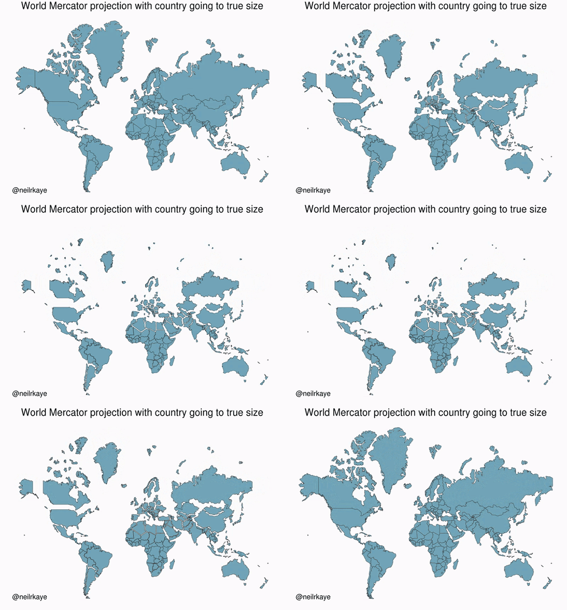
An interesting pic, from people trying to demonstrate that Africa is larger than normally envisioned.


And another one, showing that Africa and South America are huge compared to other areas:


Of course, it is not specified how "true size" was determined. Astonomical methods may produce bias in the spacing between the lat/long coordinates if the globe assumptions are incorrect.
« Last Edit: July 05, 2020, 07:55:26 PM by Tom Bishop »

Re: The Atlantic Split
« Reply #5 on: July 06, 2020, 04:08:00 PM »
How would the Sun move in this model?
Quote from: Pete Svarrior
these waves of smug RE'ers are temporary. Every now and then they flood us for a year or two in response to some media attention, and eventually they peter out. In my view, it's a case of "if it ain't broke, don't fix it".

*

Offline GreatATuin

  • *
  • Posts: 310
  • It's turtles all the way down
    • View Profile
Re: The Atlantic Split
« Reply #6 on: July 07, 2020, 09:08:13 PM »
Anomalies

There is a flight website called https://www.rome2rio.com/ which provides an easy way to find flight routes. Type in Venezuela to Liberia.

Venezuela to Liberia:

https://www.rome2rio.com/map/Venezuela/Liberia


Venezuela to Nigeria:

https://www.rome2rio.com/map/Venezuela/Nigeria


Curious. Why do Venezuelans have to go to Europe to go to countries near the African equator? If you click on the flight alternatives on the left hand menu, they all make odd flight detours through Europe.

Is it really curious? Are there strong commercial or cultural ties between Venezuela and Nigeria? How many passengers every year would take a direct flight from Caracas to Lagos? Would it be enough for an airline to make money?

Quote

On the Atlantic Split:


Interesting map. On such a map, how did the triangular trade ever take place?

Quote

Now, if you are in Brazil and want to go to Liberia, you apparently have to make a weird trip to Europe and then backtrack towards Africa:

https://www.rome2rio.com/map/Brazil/Liberia


Quite curious.


When trying to book this flight through a booking company on various dates, the flights I've found seem to want to take me from Sao Paulo to Dubai and then to Johannesburg:


You may not have heard or read about it, but there's been that global pandemic thing lately, that slightly disrupted global air traffic. It might not be completely surprising that you can't book a given route, especially if it's not one of the busiest.

But if you check http://www.taag.com/, you can already book direct flights from Sao Paulo to Luanda, Angola later this year.


And another one, showing that Africa and South America are huge compared to other areas:


Of course, it is not specified how "true size" was determined. Astonomical methods may produce bias in the spacing between the lat/long coordinates if the globe assumptions are incorrect.

Yes, the Mercator projection distorts sizes. It's been common knowledge since it was invented in the 16th century. It's not a conspiracy to make some continents look bigger than others, it's because it was meant to be useful to 16th century navigators.

Now, why do we even need map projections?
« Last Edit: July 08, 2020, 05:23:27 AM by GreatATuin »
Nearly all flat earthers agree the earth is not a globe.

you guys just read what you want to read

*

Offline GreatATuin

  • *
  • Posts: 310
  • It's turtles all the way down
    • View Profile
Re: The Atlantic Split
« Reply #7 on: July 10, 2020, 08:35:02 PM »

When trying to book this flight through a booking company on various dates, the flights I've found seem to want to take me from Sao Paulo to Dubai and then to Johannesburg:


Can you try again with flights from Sao Paulo to Addis Ababa, Ethiopia? Filter for non-stop flights and you should see results from Ethiopian airlines (ET506 and ET507).
Nearly all flat earthers agree the earth is not a globe.

you guys just read what you want to read

Re: The Atlantic Split
« Reply #8 on: July 11, 2020, 08:28:06 AM »
Further to GreatAtuin; ETH507 Boeing 787 airborne now from Sao Paolo to Addis Ababa.  Estimating 9932km in 11 hrs 10 minutes = 894 kph, or 483 kts.  Wikipedia quotes a cruise speed of 488 kts for the Dreamliner. 

What I think is interesting; its going from only 20 deg south to 10 deg north, crossing the equator, so the Great Circle Route should appear almost a straight line, slight reflex curve, on FR24's (Mercator?) projection. 

*

Offline GreatATuin

  • *
  • Posts: 310
  • It's turtles all the way down
    • View Profile
Re: The Atlantic Split
« Reply #9 on: July 19, 2020, 07:14:39 AM »
The RAF and USAAF used Ascension Island, in the Mid-Atlantic, for operations in both Africa (US aviation during WW2) and South America (British aviation during the Falkland war).

https://www.thinkdefence.co.uk/amp/ascension-island-1982-falklands-conflict/

Quote
Ascension Island, in the Mid-Atlantic, would play a decisive role in the 1982 Falkland conflict and arguably, the operation ot retake the islands would have been impossible without it.

Quote
Ascension Island has played a unique and vital part in the war…Without the existence of Ascension, without its active facilitation of the movement of our airplanes, the indispensable aviation support for our troops in North Africa could not have been accomplished at the critical period when Rommel and his Afrika Corps were literally assaulting the gates of Cairo. That aviation passed through Ascension safely and surely played its decisive part in driving the German and Italian forces from North Africa

Anyway, wherever you try to put "the split", you'll run into this kind of problems. Oceans are not just bodies of water, there are a lot of islands out there, and many of them are populated. Here's a link to generate a map of all islands with a population of more than 10: https://w.wiki/XGm . Not all of them have a permanent settlement, sometimes it's for example a scientific station that's only active during certain months of the year - but humans do go and live there occasionally. Wherever you draw the line of the split, some of these islands will be split from places that are close to them on a round Earth map.
« Last Edit: July 19, 2020, 07:55:57 AM by GreatATuin »
Nearly all flat earthers agree the earth is not a globe.

you guys just read what you want to read

Re: The Atlantic Split
« Reply #10 on: July 19, 2020, 08:45:16 AM »
The route used between the UK and the Falklands in 1982 as would be drawn on the OP’s tentative map is difficult to imagine. The entire operation would be ridiculously difficult and extremely unlikely. Yet it did happen and I know people who participated.

I also know a Falklander who visits the UK annually, using a regular flight via the Cape Verde Islands. The Falklands are on the bottom right hand of the map shown, off the coast of South America, while the Cape Verde Islands are off the west coast of Africa on the far top left of the map.

Back to the old drawing board, I fear.
« Last Edit: July 19, 2020, 09:24:24 AM by Longtitube »
Each and every nanometer of space is filled with Riemann zeta function ether waves: sound travels through ether, not air molecules. If the air is removed in a vacuum chamber, what is left is the ether, and sound does travel even in such a VC but it is not audible anymore.

Offline edby

  • *
  • Posts: 1214
    • View Profile
Re: The Atlantic Split
« Reply #11 on: July 21, 2020, 08:14:03 AM »
Great map, but a few questions to research. First, in my area of the UK 1 degree of latitude = about 111km, which is easily checked by driving distances.

But lines of latitude expand on the right and the left side of the map above. Does that mean distances are much longer on the East coast of S. America, and the West coast of Africa, than indicated on Google maps? Are the FE researchers in those places who could confirm?

Second, what lies beyond the circular boundary of the map? Is it ocean all the way to the boundary?

Re: The Atlantic Split
« Reply #12 on: August 21, 2020, 07:23:25 PM »


The propagation of maps which (essentially) lie about the relative sizes of all countries/continents within the northern hemisphere seems to be the basis of something beyond "a convenience for sailors", it's the basis of covering up the truth.

Note that there is only a small amount of shrinkage in the countries within the southern hemisphere. And the more advanced of these are in the lowest lines of latitude.

I would conclude that maps like these are very favorable to the FE assertion.

*

Offline JSS

  • *
  • Posts: 1618
  • Math is math!
    • View Profile
Re: The Atlantic Split
« Reply #13 on: August 21, 2020, 07:46:02 PM »


The propagation of maps which (essentially) lie about the relative sizes of all countries/continents within the northern hemisphere seems to be the basis of something beyond "a convenience for sailors", it's the basis of covering up the truth.

Note that there is only a small amount of shrinkage in the countries within the southern hemisphere. And the more advanced of these are in the lowest lines of latitude.

I would conclude that maps like these are very favorable to the FE assertion.

Where these sizes come from is pretty simple, globe-based map data is re-projected from a sphere to a plane. Since you can't flatten a sphere into a plane without stretching, distorting or cutting it, you get all the various types of maps.  The latitude and longitude lines stretch with the map, so are still useful in locating an absolute position.  London will always be at 52° N, 0° W no matter what shape you stretch a map into.

The Mercator projection is the most common, and the one shown here.  It stretches the map at the poles which is why the continents up north look so large.

The reason the southern side doesn't stretch as much is simply because there are not as much land south of the equator, so there is less to stretch.  The animated map cuts off most of the southern hemisphere, easily noticed as it's missing Antarctica.  You can see the full projection below.

The further away you get from the equator, north or south, the more distortion you get using a Mercator projection.

There are a lot of better flat projection methods in my opinion, but they all have same problem that you can not represent a sphere with a plane. It's just not possible to do so without distorting and all flat maps have to pick how they distort.  The best way to view data plotted on a sphere, is on a sphere.


Offline Goldie

  • *
  • Posts: 1
    • View Profile
Re: The Atlantic Split
« Reply #14 on: December 19, 2022, 03:39:38 PM »
I am looking into a variant map to the Bi-Polar model, which I call the Atlantic Split. In this variant the split occurs in the Atlantic Ocean rather than the Pacific Ocean.

Link to Bi-Polar Model overview: https://wiki.tfes.org/Bi-Polar_Model

I was able to derive a rough draft version the Atlantic Split as generated from an old version of the nullschool webapp: https://web.archive.org/web/20170731230036/https://earth.nullschool.net/#current/ocean/surface/currents/overlay=primary_waves/azimuthal_equidistant=-205.32,21.99,115/loc=154.680,-89.951


Now, the continents might not look exactly like that, as this website has limited ways to warp the map. My idea of the Atlantic Split is that the African and South American continents are on the Left and Right sides of the world, with the other landmasses in some configuration in between. Africa or South America might be smaller or less warped in shape than what is depicted. Again, there is limited control over this aid map. The continents South America and Africa should be considered to be blobs on the sides of the map.

At first glance Africa and South America seem quite abnormal, as compared to the ones we see on the Mercator Map. However, consider the Peter's Projection. The Peter's Projection supposedly provides a more accurate depiction of the continents in terms of land mass. The size of Africa and South America are much bigger in this map.


https://www.oxfordcartographers.com/our-maps/peters-projection-map/

Quote
Maps not only represent the world, they shape the way we see it. The revolutionary Peters Projection map presents countries in their true proportion to one another: it has been adopted by the UN, aid agencies, schools and businesses around the world.

WHAT IS THE PETERS MAP

The Peters World Map is an Equal Area cylindrical projection with standard parallels at 45 degrees thus resulting in a distortion of shape which is stretched about the equator and squashed towards the poles, but having the great advantage that all countries are correct in size in relation to each other.

So, it is possible that Africa and South America are much larger than normally depicted.

A gent in my yacht club is currently competing in the Golden Globe round the world yacht race. The course that he (and the rest of the competitors) has followed would be impossible if that map was even close to reality: https://goldengloberace.com/live-tracker/

Back to the drawing board, I'm afraid.

Re: The Atlantic Split
« Reply #15 on: December 19, 2022, 06:55:52 PM »
Before anyone beats me to it, can I be the first on this thread to bring up the Meteorological-Phenomenon-Which-Must-Not-Be-Named; the southern hemisphere Anomalous Winds.  There don't appear to be any, with regard to this boat race. 

The current race leader, Simon Curwen, has an average race speed so far (recorded at 16.00 UTC 19 Dec 2022) of 4.9 Kts, with his rivals  showing a decimal digit-or-2 in his wake.  Current speeds of of him and his closest (geographical) competitors appears to be in the range of 5 to 7 kts; hardly extraordinary.  I am not a sailor, but would have imagined that extraordinary winds would be driving sail-boats at extraordinary speeds. 

Two questions for resident yacht-club-guy Goldie (or any subject-matter expert);

1.  Any thoughts on the apparent speeds, and how the skippers are determining their actual position, speed and heading?  (ie GPS, astronomical sightings, LORAN).

2.  There are 2 large, rectangular (on Mercator) brown zones in the southern oceans which the boats are avoiding; out of bounds for the race?

Offline Gonzo

  • *
  • Posts: 79
    • View Profile
Re: The Atlantic Split
« Reply #16 on: December 20, 2022, 10:31:50 PM »
Quite.

And regardless of their present docility, they are only anomalous in the fact that they are strong winds. We know exactly why they are strong, and we can predict and forecast them. There's nothing unexplainable about them. They are anomalous as Death Valley is anomalously hot, The Netherlands is anomalously flat, the Atacama anomalously dry, or the fall leaves in New England are anomalously colourful.