Show Posts

This section allows you to view all posts made by this member. Note that you can only see posts made in areas you currently have access to.


Messages - Tontogary

Pages: < Back  1 ... 18 19 [20]
381
Flat Earth Theory / Re: Earths magnetic field discussion
« on: April 03, 2018, 03:02:14 PM »
Can your describe the bi pole theory, or give a link, as i have not heard that one before.

382
Flat Earth Theory / Re: Earths magnetic field discussion
« on: April 03, 2018, 02:24:11 PM »
Your picture of a radial ring magnet is just that, a ring, it does not have a pinpoint North Pole.

What you have found is a picture of a section of the lines of flux, not the whole diagram, and as you can see from the picture you provided the inner diameter of the ring is very a long way from the Center of the ring. If you provide all the flux lines you would see that there is a dead band in the Center, and the lines of flus are not vertical to the plane.

The simplistic diagram does not show how the radial field is actually made, whereas if you study how these magnets are made they are a series of bar magnets with the same pole all on the inner ring.

Your diagram does not show how the dip relative to the earth surface is vertical at the South Pole, which has been observed, as to get to that state one would need to be standing on the edge of the flat world, 90 degrees to plane of the flat world.

Show me a diagram of a radial magnet produced in a plane object, with a singular point pole, not a ring.

383
Flat Earth Theory / Re: Flat earth Chart,
« on: April 03, 2018, 01:57:27 PM »
And just to clarify, this is a "Air Map" created by a round earther, but the map is more accurate for flat earth study.

I was about to point out that you obviously did not read the notes on either side regarding Mercator projection map as, as well as the handy note and scale on the right hand side regarding distances!

However if this is what FEers believe the world to look like flat, then let me study it, and i will have some observations and questions.

384
Flat Earth Theory / Re: Earths magnetic field discussion
« on: April 03, 2018, 01:49:37 PM »
If earth was a globe, the distance round its surface at 45 degrees south latitude, couldn't be greater than it is at the same latitude to the north. However, since navigators find it to be double the distance, or double the distance it should be (according to the globe earth theory), this is cast iron proof earth is flat.

Unfortunately this is, as usual, off topic.

I posted the question about magnetism, not distances, however i can open a new thread to discuss navigation, Astro navigation, calculating distances, and spherical trigonometry if you wish, but i fear you will not follow what i post, and dismiss it as lies.

Anyway back to magnetism;

The Q&A section describes the flat earth as having a radial orientated ring magnetism, sounds awfully technical doesn’t it?
The problem with that is that such magnets are essentially series of bar magnets arranged in a RING (that word is important) with the same poles all pointing towards the Center of the ring.

Here in lies the problem.
Anyone who knows anything at all about magnetism ( i am guessing not a lot of FEers, due to lack of response to a clearly titled thread) knows that like poles repel, and therefore there is no possibility to get all of the north poles in one location, as they will tear the flat earth apart at the pole, or there will be a large area that has no magnetic field, as the poles of the individual magnet sections cannot be close together, but form part of the inner ring, which there are calculations for, but from most radial magnets i have seen, it would be fair to say would cover about 2000 to 3000 miles from the pole.

As for the South Pole, it is physically impossible to produce a truly unipole magnet, so there would be a number of south poles around the perimeter of the world, but as they radiate out starting at the North Pole, these would be hundreds or thousands of miles apart, causing massive variations in the southern oceans. Granted there is on part of the southern Indian Ocean with variations up to 25 degrees, but that is only 1 spot, and not that great in the scheme of things.

So please can we have a rational explanation of the earths magnetic field with a flat Earth? I am interested to hear what the FEers have to contribute to the debate, other than it is a conspiracy, or lies, or made up. The Q&A page makes a claim, i would like the supporters of this idea to explain what they think is happening, i wont even (at this stage) ask for proof or evidence, and will debate the physics in question, so come on, give me some theories.

385
Flat Earth Theory / Re: Flat earth Chart,
« on: April 03, 2018, 01:31:39 PM »
Our total annual budget is $0. The allocated cartography budget is $0.

We are already giving out our little free time away from work to discuss a few matters. You aren't paying us. Why do you guys complain so much?

I didnt ask about your budget. I asked for a map, or a sketch that resembles a map. You are not answering the question.

You claim there is mountains of research to back up your ideas, and i am asking you to show me the proof in a picture form of what the earth looks like, and you claim no one has paid for one yet? Or is it because you cant make any money out of it?
Rowbotham only reprinted his ludicrous theories to make a quick buck, and it seems like that is where the FEers have stopped, if it cant make money, or is not defensible, we wont discuss it, or claim we have not been paid for it.

I tell you what, describe it to me and i will draw your map for you for free, i just need some idea of what it actually is you are claiming the earth looks like.

I keep the copyright and when you are proved right I will donate half the proceeds to the FE Society. Can’t say fairer than that can I? If you are right the FES gets rich, and i get rich as well, but of course you have to be proved right 1st.... i take the time to draw your map, and you dont have to spend any dollars....win win for you Tom!

386
Flat Earth Theory / Re: Flat earth Chart,
« on: April 03, 2018, 11:21:19 AM »
Yes i can see that no FEers would be brave enough to put a map here that can be looked at and challenged. They seem to skirt around providing some form of evidence to us who can easily prove them wrong.

However i am willing to look at any evidence and see what they can show me, and make my informed comments. I can back up my comments with experience and mathematics, which is probably more than FEers can.

I notice on the Q&A section there is a map, with the comment, “this is a possible map, but not definitive”

Maps have been produced since the Middle Ages, not always to the best detail, and not always accurate, but they were produced.

Surely FEers must have some idea what the world looks like, as they all seem to agree there is a great ice wall to the south, all the way round the edge, so how hard can it be to fill in the details?
They seem to agree that the North Pole is at the Center of this map, otherwise their flashlight sun theory wont work, so we have 2 important points there, the Center, and what is there, and the edges.

Surely they have a better knowledge of cartography than people from the dark ages did? Or are they more backwards than that? They certainly claim to be more sophisticated in the arguments, so i challenge someone to point a FE map, Please?

I await with anticipation.

387
Flat Earth Theory / Re: Earths magnetic field discussion
« on: April 03, 2018, 10:21:33 AM »
Not quite right that calculation.

1 degree of latitude is equal to 60 minutes, or 60 miles.

Therefore from the pole, (or supposed Center of the FE) 45 degrees north is 45 degrees from it, or 2700 miles radius, or 5400miles diameter X Pi gives a distance travelled around the world of 16,964 nautical miles.

45South is 135degrees from the pole, or 8,100 miles from the pole, or a diameter of 16,200 miles X Pi gives a distance around the world of 50,894 nautical miles. Which is 3 times the distance.

I have sailed along the 40th parallel south, (although not all the way round, but at least 1/3rd of the way) and can assure you it is no where near 50K nautical miles. Easy to determine, as we steam at 17. Knots, multiplied by the number of hours, and we get a pretty good accurate determination of distance. So please can you tell me why i am lying. I can assure you i am not!

388
Flat Earth Theory / Re: Waves, Dimes and Elephants.
« on: April 03, 2018, 06:04:34 AM »
Tin will be dismissed by tom or parallax as fake or photoshop!

389
Flat Earth Theory / Re: Waves, Dimes and Elephants.
« on: April 03, 2018, 01:43:15 AM »
Yes i can,

I have beeen sailing since 1985, Gained my 1st certificate of competency as 2nd mate in 1989, and chief Officer licence in 1996, and my Masters licence in1999. I have been sailing as a Master of oil and gas tankers since 2004, so 14 years in command.

I can show a copy of my masters licence, although for obvious reasons (security and ID fraud being 2) will not show my licence number. As part of my navigational training we studied many subjects, Magnetism, correction of magnetic compasses, and the earths magnetic field.
Electronic navigational systems, such a GPS, transit sat NAV, as well as radio nav systems, nav aids, such as gyros and gyro compasses, radars, theory and understanding of them.
Navigation, celestial navigation which relies heavily on spoherical trigonometry, and principles of position fixing, as well as in depth position fixing from celestial bodies.
Surface navigation, using Rhumb lines, GFreat circles, composite great circles, and calculation of distances along different courses and to different destinations.
Calculation of vertical sextant angles to find distance from a known point, horizontal angles for the same, as well as bearings and ranges from objects.
Cartography, different projections of charts and why, Mercator, gnomonic projection etc, and how the world is charted.
I have spent years practicing celestial navigation, and it works...
As well as law, safety of life at sea, commercial and civil law, and loading of cargos and carriage of cargoes. Stability and damage control, rules of sailing and rules of the road. World wide weather patterns and the reasons for them
All of these things i have studied and understood to be able to pass my master mariners licence, of which i can provide a copy in a few hours. We are in the indonesian islands passages at present, it is late but i can provide my Master mariners licence.

Does that qualify Me as someone who has experienced quite a bit when it comes to actual real life experiences, and not some dragged up references for nearly 200 years ago?

Attached are copies of my licence as a Master Mariner

390
Flat Earth Theory / Re: Earths magnetic field discussion
« on: April 03, 2018, 12:37:58 AM »
If earth was a globe, the distance round its surface at 45 degrees south latitude, couldn't be greater than it is at the same latitude to the north. However, since navigators find it to be double the distance, or double the distance it should be (according to the globe earth theory), this is cast iron proof earth is flat.

Then please prove it. Your mentor Tom, asked me in another post to prove that the calculations i have been doing for years are right, so I now ask you to prove your claim, and i dont want some third party annecdote, i want diagrams, pictures and independent testimony.

Failing the above you will be proved to be wrong.

391
Flat Earth Theory / Flat earth Chart,
« on: April 03, 2018, 12:33:54 AM »
Can any Flat Earthers please provide me a link to a chart of the world? If you dare.

I would be very interested to see what they think is the North Pole, lines of longitude and latitude, and relative positions of the continents.

It will help me understand your claims better, and try to resolve where i have been misled all my adult life regarding Navigation.

392
Flat Earth Theory / Re: Waves, Dimes and Elephants.
« on: April 03, 2018, 12:23:02 AM »
I want you to be able to explain through practical experiments why the tables dont work.

That is not how things work. It was your claim, so it is your burden to demonstrate it.

I made a claim earlier in this thread about the horizon rising as an observer increases altitude, and I provided evidence and a video to support that idea. Did you see me telling people "prove me wrong?" I went and found some evidence and demonstrated that the horizon line rose with the observer.

That is what is expected of you. Demonstrate your positive claims. We frankly don't have the time, resources, or inclination to address everything. Asking others to prove a negative is not a valid form of debate.

Ok the next time we are passing a suitable piece of land i will do so, however i am sure that you will claim my photos are fake, or it was false.

Surely the burden too debunk my experiences are on you. You say they are false, therefore prove it. I have done the practical measurements, and have made the calculations, that is my evidence, you need to prove i am lying, and i have given you the tools to disprove me, therefore you should go out and prove i am wrong.

Sitting there saying you are wrong does not cut it with me.

When real scientists, not charlatans, give their method, and results, (i clearly stated i had followed the method, and have achieved the results, i.e. replicated the experiment) then other REAL scientists follow the method to replicate the results. You are not a real scientist, as all you are saying is, i dont want to follow the experiment, i just claim its false, and you need to do more and more, however your past record shows whatever photos or other evidence is placed in front of you will be claimed as photoshopped, or fake.

Be a real man of science, i challenge you, and go and do this experiment yourself, if you can work a sextant and radar set i would be most surprised though.

393
Flat Earth Theory / Re: Waves, Dimes and Elephants.
« on: April 02, 2018, 11:16:10 PM »
Quote
Given an object of known height above the datum level (sea level, highest astronomical tide, whatever is being used) it is easy to use tables, or in fact calculate the distance you are from that distance by using a sextant.

Knowing your own hieght of eye is also important, as this will give you the distance to the visible horizon, and if the base of the object is closer than the visible horizon, then that is the only calculation needed, however, if the object is further away than the visible horizon, you can still calculate how far beyond the visible horizon the object is by doing a similar calculation taking into account the Base of the object (of a known hieght) will be below the horizon, and that can be measured.

Verification is easy since the introduction of radar, i have measured the vertical angle to lighthouses, mountains etc, and been able to calculate the range of the vessel from them. I have then used the radar to verify the calculations (and tables) and have come up with the same (or very nearly the same) answer. This has been further verified by then steaming towards the object at a certain speed for a certain time, and actually covering that distance.

"Totally proven. There are studies." doesn't fly around here. We need to see the studies, see the data, and see the actual thing that is being tested.

Why did you deliberately leave out the parts of the quoted post that gave you exactly what you are asking for?

Are you talking about this?

Quote
https://webapp1.dlib.indiana.edu/virtual_disk_library/index.cgi/5429240/FID89/PUB9/chapters/tblexpl.pdf

Tables 13, 14 15 and 16 all are used. The mathematics are provided.

That's a document titled "explanation of navigation tables". This is not study. It is explaining how tables work.

Yes the link does explain how the tables are calculated, the mathematics involved, so you can do your own calculations.

I have used the calculations, and tables, and they work, and have told you that they work. Please can you do some experiments, and observations to prove i am a liar, and i will look at your “experiment” and see what you have to say. Calling me a liar does not cut it with me. I want you to be able to explain through practical experiments why the tables dont work.
As part of my job i also teach apprentices in navigation, and where we pass suitable landmark this is one of the methods that we teach, and i verify the observations by radar. How do you do verify your distances when you do the experiment? Oh thats right you have never done it yourself have you?

394
Flat Earth Theory / Re: Waves, Dimes and Elephants.
« on: April 02, 2018, 11:04:58 PM »
Tontogary is a classic example of someone who thinks he is going round the globe, but in reality isn't.

Then please explain where i am going, and how i am deluded into thinking i went around the globe. I would be fascinated to hear how you are able to know this better than i am, one person among thousands, if not millions who have.

395
Flat Earth Theory / Re: Waves, Dimes and Elephants.
« on: April 02, 2018, 03:20:34 PM »
Yes i can,

I have beeen sailing since 1985, Gained my 1st certificate of competency as 2nd mate in 1989, and chief Officer licence in 1996, and my Masters licence in1999. I have been sailing as a Master of oil and gas tankers since 2004, so 14 years in command.

I can show a copy of my masters licence, although for obvious reasons (security and ID fraud being 2) will not show my licence number. As part of my navigational training we studied many subjects, Magnetism, correction of magnetic compasses, and the earths magnetic field.
Electronic navigational systems, such a GPS, transit sat NAV, as well as radio nav systems, nav aids, such as gyros and gyro compasses, radars, theory and understanding of them.
Navigation, celestial navigation which relies heavily on spoherical trigonometry, and principles of position fixing, as well as in depth position fixing from celestial bodies.
Surface navigation, using Rhumb lines, GFreat circles, composite great circles, and calculation of distances along different courses and to different destinations.
Calculation of vertical sextant angles to find distance from a known point, horizontal angles for the same, as well as bearings and ranges from objects.
Cartography, different projections of charts and why, Mercator, gnomonic projection etc, and how the world is charted.
I have spent years practicing celestial navigation, and it works...
As well as law, safety of life at sea, commercial and civil law, and loading of cargos and carriage of cargoes. Stability and damage control, rules of sailing and rules of the road. World wide weather patterns and the reasons for them
All of these things i have studied and understood to be able to pass my master mariners licence, of which i can provide a copy in a few hours. We are in the indonesian islands passages at present, it is late but i can provide my Master mariners licence.

Does that qualify Me as someone who has experienced quite a bit when it comes to actual real life experiences, and not some dragged up references for nearly 200 years ago?

396
Flat Earth Theory / Re: Moon and Moon Landing.
« on: April 02, 2018, 11:31:40 AM »

And how do satellite tvs work? I thought satellites were another misconception/conspiracy theory. If the weather is bad between your dish and the satellite, it must prove satellites are real.
Also even someone who is as blinkered as you must admit there is not that much rain or heavy clouds between the earth and the motion to obscure a signal, plus the receiving ground stations are somewhat bigger than your teeny little sky dish.

I have to admit, using satellite TV as proof of a flat Earth shows commendable nerve. What the flat Earth theory is about satellites I can't begin to imagine.
Apparently they are all lies, and a conspiracy. In another thread it was claimed that the sat tv boxes are doctored to make us believe they are using a satellite!

397
Flat Earth Theory / Re: Moon and Moon Landing.
« on: April 02, 2018, 07:39:04 AM »
There is lots of footage on YouTube to demonstrate the fakery. The way the astronauts bounce as if they are on wires for one. The pathetic lunar landing module that looks like it was wrapped in tin foil. And how is it that they can get a little tv camera to broadcast images, from the moon, in 1969, uninterrupted, back to earth? Yet today, in 2018 if it gets a bit cloudy outside my Sky TV loses its satellite signal? No, primitive 60's technology couldn't achieve that. However, if you could prove it happened, it wouldn't disprove flat earth, just prove NASA went to the moon. They planted a flag, yes? Why was it blowing? Why can people not look through a powerful telescope and see a flag? There isn't one. Please provide proof of the flag that's allegedly there and silence us all.

And how do satellite tvs work? I thought satellites were another misconception/conspiracy theory. If the weather is bad between your dish and the satellite, it must prove satellites are real.
Also even someone who is as blinkered as you must admit there is not that much rain or heavy clouds between the earth and the motion to obscure a signal, plus the receiving ground stations are somewhat bigger than your teeny little sky dish.

398
Flat Earth Theory / Re: Law of Perspective - Distance to Horizon
« on: April 02, 2018, 07:14:16 AM »
It took it's time, to follow these argument, but in the end - for me - it appears quite simple.
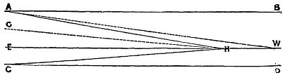
You know this diagram from http://www.sacred-texts.com/earth/za/za32.htm ?


The distance of the vanishing point - aka the horizon - is defined by the limited resolution of the naked eye, where lines from the observers eye E to the vanishing point H and the surface C to H build an angle less than 1 minute of degree.
Rising observers position will broaden this angle and move point H (horizon) farther away, until the 1 minute criteria is met again.

But what, if observer has "hypervision" and could resolve angles less than 1 minute.

Yes. There are many accounts in the Flat Earth literature of telescopes restoring half sunken ships across calm bodies of water, showing that they are not really behind a "hill of water".

In cases where the water is turbulent, the shinking ship effect cannot be restored, showing waves to be the cause.

Ok then Tom, if that is the case then please can you explain this;
We have on my ship 2 different sextant so, one has an eyepiece with no magnification, the other a monocular with 4 times magnification. Taking a sextant altitude of a star or a heavenly body requires measuring the angle between the apparent horizon and the body, accuracy is grater than 0.1 minute of arc.
When using the 2 separate instruments the same value is obtained, even when accounting for index (instrument) error. The apparent horizon is constant dependant on the observers hieght of eye.

Waves cannot be interfering with the horizon, as navigation relies upon measuring the difference between the actual Zenith distance (from a point 90 degrees above the observers head with the calculated Zenith distance (calculated using an assumed position on the earth. 3 or more of these observations give a reasonably accurate position, and this method of navigation has been practiced for hundreds of years, and was used to map the world accurately (within a few miles, and mostly within a few metres) for hundreds of years before the introduction of Satellite navigation.

If magnification altered the horizon, then the calculations would be inaccurate, and no positions could be obtained. The same if waves were present, the measured altitude would vary, resulting in inaccurate results.

One last point here. If satellites are a hoax, how do we navigate using sat navs on ships, cars, and trucks? How do we communicate with shore when we are hundreds, sometimes thousands of miles from the nearest land?

Waiting in anticipation for your science based responses, and not just vague references to 18th century accounts from obscure texts.

399
Flat Earth Theory / Re: Waves, Dimes and Elephants.
« on: April 02, 2018, 03:25:18 AM »
Ok lets try and put this one to bed shall we.

I am a navigator, and have been for 35 years on varying ships, and can tell you for sure the earth is a globe, because i have sailed around the world, and end up nearly the same place by sailing east or west.

The argument around the horizon is really simple to observe and see.

Mariners have been using tables and maths to work out distances from objects of a known height for hundreds of years, and they are proved to be accurate, there are numerous references to them, and they work. I have done it myself and seen it.

Given an object of known height above the datum level (sea level, highest astronomical tide, whatever is being used) it is easy to use tables, or in fact calculate the distance you are from that distance by using a sextant.

Knowing your own hieght of eye is also important, as this will give you the distance to the visible horizon, and if the base of the object is closer than the visible horizon, then that is the only calculation needed, however, if the object is further away than the visible horizon, you can still calculate how far beyond the visible horizon the object is by doing a similar calculation taking into account the Base of the object (of a known hieght) will be below the horizon, and that can be measured.

Verification is easy since the introduction of radar, i have measured the vertical angle to lighthouses, mountains etc, and been able to calculate the range of the vessel from them. I have then used the radar to verify the calculations (and tables) and have come up with the same (or very nearly the same) answer. This has been further verified by then steaming towards the object at a certain speed for a certain time, and actually covering that distance.

https://webapp1.dlib.indiana.edu/virtual_disk_library/index.cgi/5429240/FID89/PUB9/chapters/tblexpl.pdf

Tables 13, 14 15 and 16 all are used. The mathematics are provided.

The above links explain the maths and tables to use, and the thing is THEY WORK, so if there was no curvature of the earth, then the tables are wrong, and there will be a hell of a lot more ship wrecks around.

Either i am lying, or have been fantastically duped and lucky to get away without running my (large) ships aground all these years.

Also look at this reference, clearly explaining why an object dips below the horizon. There are pictures etc, plus diagrams. I would love to have explained to me why the science behind what i have known and practiced to be true is wrong.

http://www.splashmaritime.com.au/Marops/data/less/Nav/Vsa.pdf

Finally when looking at the home page of this site it is stressed that pictures and videos and wiki references should not be trusted as they are easily manipulated, why therefore does Tom continue to try to provide references to textbooks written over 150 years ago, when our understanding of science was more primitive, indeed we had not even flown an aeroplane at that point, and Darwin had just publish Origin of species, and most people believed in creationism, as opposed to evolution. Please lets have some sense of reality here.
Although i have provided web links, one of them is to a universally accepted journal of navigation that has been published for over 200 years, and the tables are accurate. Have been proved so many times by practice, and measurement, as well as theory.

Please provide solid evidence other than “i believe” or “it has been proved” without explaining why.

400
Flat Earth Theory / Earths magnetic field discussion
« on: April 01, 2018, 03:20:17 AM »
So if there is an ice wall at the southern extremities of the world, how are the Antarctic explorers explained away?
If someone is following a compass south, they get to the ice wall, or Antarctica, they then keep walking south to the South Pole (magnetic and geographic poles differ) where the dip of the compas needle is 90 degrees to the plane of the surface. Then keep on walking away from that point, they “appear” on the opposite side of the world.
If as is claimed the earths magnetic field is similar to a radial magnet, there MUST be a North Pole, which no one disputes, but also there MUST be a South Pole, which is seen to be beyond this ice wall, which we call Antarctica.
North of the magnetic equator, which runs around the earth at the same latitude as Singapore, a north seeking compass needle will dip below the horizontal, at a steadily increasing angle to the plane of the earth, until at the pole it will be vertical at 90 degrees down.
When passing south of the magnetic equator, the same needle points above the horizontal in line with the earths magnetic field, steadily increasing until at some point it will point 90 degrees to the plane of the surface. This is the other pole, or South Pole. If the earth has a radial magnetism (similar to a loudspeaker etc) then standing at that point you will be either on the underside of the world, or on the bottom of a sphere.

Would any flat earth era be able to claim how this is possible? Ie to stand on the underside of the world?

Also when people have crossed Antarctica, they take a course south to the South Pole, then when they reach there, North and appear on the other side of the “flat” world. To do so with the flat world they must circumnavigate the edge of the world going either east or west, which none of them do.

Pages: < Back  1 ... 18 19 [20]