Just as usual, I have to do the RE's homework for them.
Here is the original link to the photograph provided by rama set:
http://christinedemerchant.inthebeach.com/niagara-falls.htmlThe author of the photograph provided no caption, no estimate at all.
Let us add 1.5 km to the distance (Niagara Falls - Toronto) and go to St. Catharines.
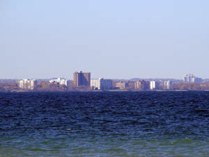
https://www.flickr.com/photos/j-a-x/129240474/sizes/l/in/photostream/ROGERS CENTRE: SKY DOME clearly visible in the photograph; however IT PROVES THE FLAT EARTH THEORY DIRECTLY AND EXACTLY.
Height of Sky Dome: 86 meters, the building itself can be seen without any terrestrial refraction in the photograph, but we will include 10 meters, for the sake of the discussion; that is, the influence of the refraction will be some 10 meters...
Two other photographs, taken right there, on the same beach:
http://valdodge.com/wp-content/uploads/2007/08/pirate-ship-5137.jpghttp://valdodge.com/wp-content/uploads/2007/08/mirage-across-the-lake-5112.jpgThe altitude of the photographer can be easily estimated to be at or around 10 meters (if we would ascend to some 20 meters, that would mean that we are on top of a five-story building; certainly not the case here, as we can see from the photographs themselves; I would estimate some 5 meters, but we will go to 10 meters).
On a round earth, taking refraction into account, and ascending to some 10 meters, it would still be impossible to see the rooftop of the Sky Dome.
In order to see the roof top of the Sky Dome, we would have to ascend to at least 20 meters, that is, on top of a five story building; as we can see from the photographs taken right there, we are right on the St. Catharines beach itself.
Data for St. Catharines, Lake Ontario, distance to Toronto, 50 km:
2 meters (observer) - 158 meters (visual obstacle)
3 - 150.5
5 - 138
10 - 117.5
Now, the fact that the lower portion of a building/ship cannot be seen in some photographs is a result of the quality of the camera used:
http://www.flickr.com/photos/j-a-x/150629243/ (CN Tower barely visible)
http://www.flickr.com/photos/j-a-x/83867796/ (with a better camera, more details become visible, IT MATCHES EXACTLY THE PHOTOGRAPH FROM NIAGARA FALLS)
http://www.flickr.com/photos/j-a-x/129240474/sizes/l/in/photostream/ (and the rooftop of the Sky Dome very visible, completely impossible on a round earth)
http://www.flickr.com/photos/planetrick/487755017/http://www.flickr.com/photos/planetrick/487726854/in/photostream
(both photographs taken right on the beach, as can be seen in the captions, and in the rest of the photos)
DISTANCE: 65 KM
VISUAL OBSTACLE: OVER 200 METERS, YET THE OTHER SHORELINE IS IN PLAIN SIGHT