Show Posts

This section allows you to view all posts made by this member. Note that you can only see posts made in areas you currently have access to.


Messages - Longtitube

Pages: [1] 2 3 ... 11  Next >
1
Flat Earth Investigations / Re: Solar Eclipse of Aug 12, 2026
« on: January 18, 2025, 08:59:10 PM »
As we've discussed over the last 15+ years, the eclipse predictions are based on patterns rather than an actual geometric model. The denialists are defeated on that point every time it is discussed. Since the predictions are not based on a geometric RE model it creates doubt in the mind, and further evidence that the eclipse predictions do not follow that model fosters cynicism.

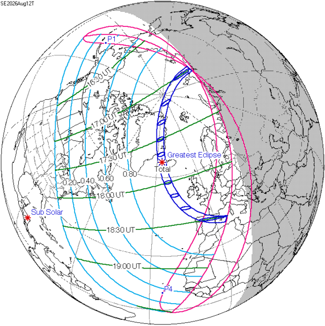
Take a look at the Solar Eclipse of Aug 12, 2026, which will pass over our favorite future US protectorate:


Notice anything odd? During the eclipse the shadow of the Moon will be moving vertically in a North-South direction. This is quite odd, considering that the Moon is said to travel around the Earth in a East-West direction (or West-East, if you want to argue about rotating earth semantics).

The best excuse you can expect for this typically amounts to "you haven't considered that the Earth is tilted", without expanding further. But any possibility of a coherent explanation can be easily dismissed, since in the Round Earth Theory the Moon is traveling in the same plane of the Sun, and only misaligned by 5 degrees. They are essentially on the same plane. The tilted Earth effect must also occur with the Sun. Reviewing the path that the Sun makes over the Earth, it is difficult to see how the Moon's shadow can move in this direction.

Is that really the most outlandish image of the predicted eclipse path you could find? This took moments to find:


And since the Wikipedia image is public domain, why not show it too?


This one shows the predicted eclipse path on the globe, making it altogether more understandable: the eclipse is forecast to begin off the northern coast of Siberia and finish over the western Mediterranean. Remembering how accurate the predictions were of an eclipse in 1999, also in August, and how I was able, having known for 20 years, to travel just 20 miles to see it completely black out the sun, it would be useful to know how the Saros cycle patterns predict the precise timing and exact location of an eclipse so accurately. It would also help your case to plot the 2026 path on a flat earth map instead of your bad Mercator projection of the globe – I mean, Greenland looks even bigger than Canada and Svalbard at least as big, if not actually bigger than the UK: the ratios in each case are roughly 1:4, oops.

If you're going to poke holes in eclipse calculations, you're going to need more than that.

2
Flat Earth Community / Re: The Final Experiment
« on: December 20, 2024, 10:38:47 PM »
It should be fun to watch what develops, here and elsewhere.

You may be in the wrong community then. It is a different Flat Earth community which says the Midnight Sun is impossible. This community has always accepted the Midnight Sun in its models and portrays several mechanisms in its materials, which relay that the Antarctic midnight sun has been in Flat Earth models since at least the 1920's. Even in the classic Monopole model, the magnifying dome demonstration for the seasons appears to make a midnight sun.

It's also plausible that our official celestial model for Flat Earth, the  EA Model, could be extended predict a midnight sun. If the light of the sun actually takes the shape of something similar to the closed loops of magnetic field flux lines, it could be that the earth is interrupting the natural path of the Sun's light and that the rays on a larger scale could loop around and appear to be coming from the opposite direction to a distant observer.

If we take one of the upwardly bending light diagrams in the link above and simply extend the loop of one of the rays which intersect with the earth, it loops around and appears to be coming from an opposite direction.


This isn't new, and I have my own questions about the particulars of how this dipole shape would appear, but the above appears to demonstrate that a midnight Sun is not an impossibility in current constructs.

Thank you for the sketch, but it doesn't appear to have uploaded completely – there are no annotations to explain what we're looking at, where an observer would be or where the sun is.

3
Flat Earth Community / Re: The Final Experiment
« on: December 18, 2024, 09:29:23 PM »
It's been fascinating watching the footage from Antarctica: now that the trip has ended there should be more bandwidth-hungry content to enjoy or fulminate at. What's also fascinating is the reactions from both sides, globe and FE, to the expedition, to the videos, to the experiments, to the very idea of going to Antarctica for real. I was interested in Jeran's remarks in his last livestream before leaving for Punta Arenas to head home – he doesn't seem to have enjoyed Antarctica as a destination. There's an undeniable bit of homesickness too.

I've seen a lot in people's comments to gasp, shake head at or just laugh. This thread has its place in the panoply of reactions and opinions from all parties: not as funny as I've seen, not such full-strength seething and coping, and nowhere near as outlandish as some, but a fairly interesting sample all the same. It should be fun to watch what develops, here and elsewhere.

4
Flat Earth Community / Re: The Final Experiment
« on: December 16, 2024, 10:02:05 PM »
Well whaddya know, they actually got to Antarctica and apparently no-one has been scammed. Lots of interesting footage of the Union Glacier site and the sun blazing away 24 hours a day from both globe and FE participants. Some people took "do your own research" seriously and it's been fascinating.

5
When we look closer at the details we just see anomalies and that things are not really in accordance with what is generally claimed at face value.

Indeed: the OP (and your next post) rewards closer study.
 
In this sort or race for the "around the world sailing record", the goal wasn't necessarily to make a perfect circumference around the globe for obvious reasons, and is really the fastest time someone could sail a distance of 21,600 nautical miles. Francis Joyon and François Gabart made this path:

https://goldengloberace.com/the-route/


This path takes place further northwards near the continents. The total course is 30,000 miles, but they only count the best time to 21,600 nautical miles for the specific record, since this is the circumference of the RE in RE Theory.

Incorrect.
When Joyon and Gabart and his crew (edit: Gabart took the solo record on a different multihull) lifted the record for sailing around the world, they also won the Jules Verne Trophy and it is a condition of that trophy that record setters begin by crossing a line between Créac’h lighthouse on Ushant Island, off the French north west coast and the Lizard lighthouse off the English south coast. Their time is to sail around the world leaving the Capes of Good Hope, Leeuwin and Horn to port (on the left) and re-cross that same line in the western English Channel, not to complete 21,600 miles. There are no restrictions on the type of yacht used, as long as it is capable of sailing around the world unaided.

That map shows the track of the Golden Globe 2022 race, a race using traditional yachts in the style of Sir Francis Chichester's famous Gipsy Moth IV, which generally takes 9 months to complete and high-tech aids like GPS are forbidden, it's sextants and chronometers for navigation. It starts and finishes at Les Sables-d'Olonne on the French west coast. about 180 miles from Ushant, and there are also mandatory calling points where each yacht stops in close sight of land for 90 minutes.

It looks like you guys are claiming that she had a bad boat. According to Guinness World Records Lisa Blair holds the record for "Fastest circumnavigation of Antarctica by sailboat". She did it in 92 days 18 hours 21 minutes 22 seconds. We know that hundreds of people are trying to beat world records, and there are even yearly races around Antarctica (which we are often pointed to, but the details are rarely discussed). This represents the best boat, so your arguments are pretty invalid.

Joyon's and Gabart's IDEC SPORT (formerly IDEC 3) is 31.5m long, Lisa Blair's Climate Action Now is half that length. IDEC SPORT carries far more sail than Climate Action Now and uses foils which lift the trimaran partly out of the water to reduce drag and increase speed to peaks of over 40 knots; Lisa Blair's boat has none of these. You might think Blair's is a bad boat, others would say it's a completely different boat and so your argument about round-Antarctica times falls.

The race around Antarctica happened in 2008, but does not appear to have happened since. If you know of hard data about more recent Antarctic Cup yacht races, I'd really like to know, I enjoy keeping up with these kind of events.

Finally, for anyone who is interested in sailing closer to the Antarctic ice and the weather and winds encountered, here's an account of Katharsis II skippered by Mariusz Koper, which holds the record for a yacht sailing around Antarctica below 62 deg S latitude. The anomalous winds feature prominently.

https://www.yachtingworld.com/voyages/sailing-antarctica-record-breaking-voyage-around-southern-continent-123341

6

I looked at your map. The only winds not traveling in the same easterly direction are those eddys forming close to land she wasn't sailing in those areas.

It is bizarre to provide your source as some kind of counter.


A source for her route? 

You realise of course that this is a live map, not instantaneous indications of the wind at the time she was in each area.  At the latitudes between 45S and Antarctica the general trend is westerly (ie blowing towards the east), but there are significant times when the wind varies considerably, from all points of the compass.  Do you think that those times and "eddies" don't count?  To claim that "winds on the inside of the ice ring always travel the same way" is complete fantasy. 

But don't take my word; this from her blog Day 79:

"Hi All,
 
 Last night I finally managed to get to bed by around 3am and by 4am the winds had started to veer from the SW to the W before shifting to the NW and build in strength.  I needed to put a gybe in, but I decided to wait until first light to make it a little easier
". 

You'll know of course that a gybe is a similar manouver to a tack, but performed before the wind, so more hazardous.
She ventured a little off course in that instance, I suspect, but as I stated earlier, she was traveling with the wind.

Like I wrote, it is indeed bizarre you would provide a map that does not show an Ice Ring and only shows those eddys that are blowing to the W. She was probably caught up in one  of those.

For information, Lisa Blair's course around Antarctica, as shown on her own site https://lisablairsailstheworld.com/antarctica-2   Both her first attempt in 2017 and the record in 2022 are shown. The 2017 course is particularly interesting for one that doesn't keep to a fairly uniform easterly track.

This also handily shows why round-the-world record attempts have a limit in the latitude south permitted since the globe distance around Antarctica is notably shorter at 60 deg S compared to 45 deg S.

7
You're comparing racing cycles with motorbikes: Lisa Blair's monohull ex-racing yacht, although no slouch, is nowhere near as fast as IDEC SPORT, formerly IDEC 3, a multihull built especially to break transoceanic sailing records. IDEC averaged almost 30 knots crossing the Atlantic in 2007, at least three times the speed of a racing monohull like Climate Action Now.

8
Flat Earth Theory / Re: Finding Polaris and FE model
« on: August 21, 2024, 08:21:38 PM »
It's not the "FE Equator", it's how 0 degrees latitude is defined. The hint is that 90 degrees latitude is the North Geographic Pole, and 0 degreed latitude is the Equator, which is also the angle in the sky where the North Star would be to the observer.

I presumed you were talking about an FE definition of the equator, since the globe equator is the imaginary line of all points equidistant from the north and south poles – hence the name, equator. It still leaves the problem of Polaris being not quite at the celestial north pole. For naked eye observations this doesn't matter much, but for accurate navigation it really matters. A yachtsman heading for San Francisco and using an uncorrected sighting of Polaris to measure his latitude runs the risk of possibly coming ashore at Point Lobos, or maybe Timber Cove – both are within the possible error range and would be both embarrassing and expensive.

9
Flat Earth Theory / Re: Finding Polaris and FE model
« on: August 18, 2024, 01:37:18 PM »
Why would you? The location of the equator is defined as where Polaris intersects the horizon as it descends when you recede from North to South.

Fascinating! So the FE equator is actually moving through the course of the day, since Polaris isn't in a fixed position in the night sky as we see it. Polaris has a declination of 89 degrees 15 minutes and 51 seconds of arc, so it actually orbits the celestial north pole in a circle of 44 minutes and 9 seconds of arc radius. This means someone near the FE equator will be closer or further away from the FE equator at different times of day by as much as 88 minutes and 18 seconds of FE latitude – just over 88 nautical miles. Navigators must account for this daily cycle in Polaris's position in the sky to avoid driving the thing on to the rocks when making for a presumed harbour.

I now understand why celestial navigation is especially tricky on a flat earth. Thanks so much for the information.

10
Flat Earth Investigations / Re: I am wondering why I do not see...
« on: April 17, 2024, 05:58:16 PM »
..Reposts a video already posted in the same thread ...

Why so I have, how embarrassing.  :o  Very careless of me, I apologise.

11
Flat Earth Investigations / Re: I am wondering why I do not see...
« on: April 15, 2024, 08:11:13 PM »
Quite by chance I came across this short explanation of the path of an eclipse on a round earth:


You might find it answers some of the above questions.

12
Flat Earth Theory / Re: The Ether vs. Rocketship Earth
« on: May 19, 2023, 08:17:56 PM »
Quote from: SteelyBob
This is simply incorrect - much like the slinky video people, you are publicly demonstrating a complete lack of understanding of basic physics. There is nothing in Newtonian understandings of gravity or F=MA etc that is at odds with what we observe in freefall, for example.

The above quotes provided by the astrophysicist at space.com and by pitt.edu show the problem with the effect that causes weightlessness - the separation of inertial and gravitational mass and their equivalence. Newtonian Gravity was rejected as incoherent because of this.

After describing the issues with Newtonian Gravity the space.com article goes on to describe Einstein's "Happiest Thought" that a man would not experience his weight in freefall as a sticking point. Einstein also repeated this thought as his basis for his theories and principle on numerous occasions. If this were cleanly explained in Newtonian Gravity and was of no relevance, why would space.com segway to this curiosity of Einstein? Obviously this does matter and the issue here is a matter of understanding and reading comprehension on your part.

You have cited nothing. On this forum you continuously post and cite only yourself as your source.

Quote
You also describe Newtonian gravity as being 'discredited'. That is very unfair on poor old Isaac. His theory has been built on, but it remains an entirely valid model for most of what goes on in our lives - bridges, aircraft, boats, rockets etc are all built using Newtonian physics and ideas of gravity - it works.

Actually those things use Newtonian gravity + the absurd mechanisms like the separation of inertial and gravitational masses that require it to work. It was on basis of this ad-hoc mechanism that the theory was discredited. The theory does not work without those mechanisms and would otherwise make blatantly wrong predictions, as explained by the above space.com article.

A theory that works is a different matter than it being discredited as an incoherent theory. You have a low comprehension of this and are using circular reasoning to justify something that has been discredited.

Tom I would like to thank you for the pitt.edu article, it's most interesting as an introduction to the development of Einstein's thinking. However, I must ask if you've read it through yourself? You claim Newtonian gravitational theory has been "discredited as incoherent", but that same article clearly says "...Newton's theory works extraordinarily well for the weak, static gravitational fields of our solar system. I'm still not sure what your difficulty with the equivalence principle is: that inertial and gravitational mass are equivalent is a great mystery?? There are still mysteries that scientific enquiry hasn't solved...

13
Flat Earth Theory / Re: The Ether vs. Rocketship Earth
« on: May 04, 2023, 08:33:48 PM »
What's the point of this? Did the video get cut short before explaining something – if so, please repost it? Apart from the Glaswegian "eloquence" at the beginning, what I saw was mostly pretty coloured graphics with a musical background.

That's interesting that it went over your head. May I ask what your beliefs are regarding Earth and gravity?

No, wait, I missed the brief advert for the book; presumably the video is meant to be that length. I still don't understand the point of this in an FE Theory forum: if you mean us to read Mr Wheeler's book and then discuss it with you, why not say so? Always assuming it's relevant to FE Theory, that is.

14
Flat Earth Theory / Re: The Ether vs. Rocketship Earth
« on: May 04, 2023, 06:51:05 PM »
What's the point of this? Did the video get cut short before explaining something – if so, please repost it? Apart from the Glaswegian "eloquence" at the beginning, what I saw was mostly pretty coloured graphics with a musical background.

15
Gravity:


The guy in the video is Theoria Apophasis, also known as The Angry Photographer, also known as Ken Wheeler. His YouTube channel is https://www.youtube.com/@kathodosdotcom.

I make no comment on his channel, videos or knowledge – this is only for information. You can make your own assessment of his opinions.

16
Flat Earth Community / Re: Globebusters' Bob Knodel Passed Away
« on: April 09, 2023, 01:56:48 PM »
I'm sorry to hear of Bob's sudden passing. My condolences to his family and all who knew him. A sad day.

17
Flat Earth Theory / Re: Curvature of the Horizon
« on: April 02, 2023, 04:11:23 PM »
What you say is almost true and in the spirit of what I am saying. But there are no straight lines on a globe. They are all curves. So i walk 1.57 miles from the north pole heading due south to the north pole. The line I have walked is a curve although it will look straight if looking from above and it will feel straight to me. It is a curve. And when i have travelled that 1.57 miles curve my rate of drop in height will be 1 mile (for each 1.57 miles).

Perhaps we ought to consider where you got the "magic number" of 1.57.


It's not magic at all, it's just half of pi. Having revisited junior high school mathematics and determined the distance from pole to equator is the globe's radius times half of pi (correct), you have mistakenly thought this ratio is a constant amount for the distance travelled compared to vertical drop from pole to equator. If the sphere has a radius of 250m, the distance from top to "equator" position is ½ x pi x 250 = 392.5m (and the vertical drop 250m.) If it has a radius of 1700 miles, the distance from top to "equator" position is ½ x pi x 1700 = 2669 miles (and the vertical drop 1700 miles.)

But the only sphere where travelling a distance of 1.57 miles on its surface from the top results in a drop of 1 mile is on a sphere of radius 1 mile. And the earth is a great deal larger than that.

(edited for clarity)

18
Flat Earth Theory / Re: Curvature of the Horizon
« on: April 01, 2023, 09:27:03 PM »
I have revised the image to hopefully better explain this.

Instead of walking from N to E1 imagine walking from N to X. This is half the distance to the equator and represents one eighth (1/8) of the earths circumference ie 3,113 miles.  Can we agree on this?
If so the drop/fall/decrease in height in relation to the north pole (call it whatever) will be equal to 1,982 miles ie one half (1/2) the radius of the earth. Can we agree on this?
If either of the above figures are incorrect please tell me how?

Accepting the above if we divide 3,113 miles by 1,982 miles we get a drop/fall/decrease in height in relation to the north pole of 1 mile per 1.57 miles travelled.

Like it or not and forget what I have called these dimensions does anyone disagree with these maths?

Hopefully not. And regardless of what others have said every single infinite point on a circle is at the 'top of the curve'. Above that point the circle curves away as does it below that point wherever that point is on the circle. And as a circle is one continuous curve there are no parts of the curve that are any different to other part. Take any two segments of the curve and they will be identical no matter where on the circle they came from.

Now instead of me walking 3,113 miles I am going to divide the circle into 360 (purely for conventional purposes - I could have chosen any figure to divide it by; 100, 125, 299 - it wouldn't make any difference). The circumference of the earth divided by 360 = 69 miles. I am now going to walk that 69 miles from the north pole. And when I have finished I will be at a point on the circle some 43 miles below the north pole. Forget linear dimensions they don't matter. The fact is I will have dropped by roughly 43 miles. Or to make it simpler 1 mile for every 1.57 miles travelled around the circumference. And if someone stood at the north pole and watched me walk 1.57 miles away from them I should be at a point 1 mile below them. These figures are irrefutable. Its down to the wording. If anyone disagrees can you please do so in layman's terms? Many thanks

Well, yes we do disagree with your maths and find the figures entirely refutable. In layman's terms, I'll try drawing out what you are actually describing. Starting at the north pole, you travel 1.57 miles and find yourself 1 mile lower than the pole:–


Another 1.57 miles and you're another 1 mile lower than the pole:–


On and on, for each 1.57 miles you travel, you're another mile lower than the pole:–


Does the path travelled bear any resemblance to the curve of a globe? No, it doesn't, it's a straight line: you are travelling down a constant slope.

If you disagree, explain in layman's terms.

19
Flat Earth Theory / Re: Why are all FE models discs?
« on: January 03, 2023, 08:30:28 PM »
Latitude and Longitude are references ultimately based on astronomical phenomena. The Latitude is based on the angle of the North Star in the sky (for the NH) and Longitude is related to clocks and time zones. You might know your Lat/Lon coordinate point, but this would do nothing to show the distance between those points. This is how GPS, and formally the land-based LORAN, operate. The station knows its own coordinates and it is giving you your own coordinates based on triangulation.

AATW has already dealt with GPS and trilateration, but you're also incorrect that LORAN used triangulation. It used multilateration to fix a position, as did its shorter-range cousin the Decca Navigator system.

https://en.wikipedia.org/wiki/Loran-C


20
Flat Earth Theory / Re: Why are all FE models discs?
« on: January 02, 2023, 05:01:02 PM »
For long distance measurements in the 17th century and prior the first step was to get your longitude and latitude. From that you could know how far away another place with a known latitude and longitude was if you knew how many miles a degree took upon the earth. It was "known" how many miles a degree took upon the earth based on a study, to which they would take and apply to Lat/Lon coordinates on a theoretical basis. They were not stringing ruler tape or chains for all long distance work. Long distance 'measurement' worked, and still works, based on a series of assumptions.

How very interesting, how was this number of miles per degree "known"?

To answer that, here's a link to a 17th century work on the same subject. The author sought to verify the "known" number of miles per degree by actually measuring, by surveyor's chain, the distance from London to York and comparing the difference in latitude and longitude with this directly measured distance. In the course of the book, he also mentions how others through history had physically measured distances to determine, say, latitude difference compared to distance in cubits or stadia etc.

The Seaman's Practice by Richard Norwood:– https://ia803203.us.archive.org/16/items/norwood-1699-the-sea-man-s-practice/Norwood%201699%20The_Sea_man_s_Practice.pdf

You'll find he uses 17th century English spelling – it'ʃ difficult to ʃay at timeʃ how theʃe thingʃ might be pronounced without aʃsiʃtance...  ::)

Pages: [1] 2 3 ... 11  Next >