I believe that the argument with polar views you are posting, with the line going across the Northern or Southern areas, are implicitly assuming that the earth is flat and that the sun is close to the earth.
That is not implicit. To the contrary. If you are at a high enough latitude and the sun is at a high latitude in the same hemisphere but on the other side of the globe, you'll see it over the pole. On earth, that latitude is marked by the Arctic (and Antarctic) Circle. It's why the sun doesn't set to those above the Artic Circle when the sun is transiting at the latitude of the Tropic of Cancer. Likewise for the Antarctic Circle and the Tropic of Capricorn.
I can see how that could work on a flat bipolar model of earth, although not at the lines of bearing observed.
I can see how that could work on a flat AE model of the earth, but only for northern latitudes. Southern latitudes appear impossible. And again, the bearings are wrong.
At least as I work it out. If I'm doing it wrong, someone - a sincere advocate for a flat earth model preferably -- should step up and show me how to do it right. 6 days of me asking this question...
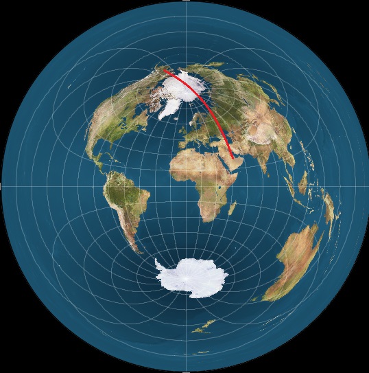
One can make a line on a globe between Cincinnati and China across the Northern Polar area, but that doesn't mean that the sun can come out of the North Pole.
Why would one randomly make a line between Cincinnati and China over the Northern Pola area? Is the sun over Cincinnati and an observer in China seeing the sun (or vice versa)?
In fact, one can make a line that goes to the South of Cincinnati, around the Southern Polar area to China, just as straight, but that doesn't mean that the sun is going to come out of the South Pole.
And that's no surprise, because that's just randomly connecting two points.
The non-random approach is to first identify the location of the sun over the earth. That's on endpoint. Then find the location of an observer who is seeing the sun. That's the other endpoint. Now THOSE two points aren't random. The straight line path over the earth (on a globe) is the great circle arc that connects those two points. That will define the angle/direction an observer is facing in order to be seeing that sun. And, yes, on a globe, you do sometimes have to face north or south to see a sun that's to the west or east according to longitude.
I showed that in my June 28, 2017 Alaska photo.
I can understand how that can be so on a globe. What I'm asking is how was I seeing the sun setting after midnight to the NNW if the earth was flat?
Use your preferred bipolar model. Was the sun's path like this?

Or this?

Or this?
Or something else? I'm not "fabricating" data here. I'm just offering up some options because I frankly don't know how to do it for a flat earth, and despite my repeated requests, no one is showing me. Simply focusing on how it can or can't be done on a globe doesn't answer the question how it can be done on a flat earth. The earth isn't flat by default if you don't get the globe answer. You still need to compose a flat earth answer.
I've spent a lot of time explaining to you how it CAN work on a globe. You don't get it. Fine.
Now, explain to me how it can work on a flat earth. I might not get it, but at least try to explain it to me as I've tried to explain the globe to you.
The geometry of the Sun-Earth system and the angle of the light rays and the earth seem to say that there are limits to how far north and how far south the sun should appear to the observer.]
Yes, there are. You are right about that. You can't just take any two points on a globe, draw a great circle arc line between them and think my globe explanation means the sun at one point will appear along that line to an observer at the other point. I don't know why you think that should be the case given what I've explained.