The maps we gave out were for visualization purposes. If you're not going to give us data showing conclusively what the layout of the world is, then I am not sure it is possible for you to critique anything.
You've hit the nail on the head. There have been maps that are essentially correct, though incomplete for at least half a millennium and those maps are projections of a Globe.
. . . . . . . . . . . . . . . . . . . . . . . . . . . . . . . . . . . . . . . . . . . . . . . . . . . . . . . . . . . . . . . . . . . .
This 1698 map of the known world sure does not look like a map of the flat earth: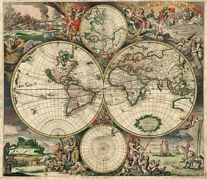
Map of the world produced in 1689
by Gerard van Schagen. |

"The light of navigation", Dutch sailing handbook, 1608, showing compass, hourglass,
sea astrolabe, terrestrial and celestial globes, divider, Jacob's staff and astrolabe. |
In 1537, Pedro Nunes published his Tratado da Sphera. In this book he included two original treatises about questions of navigation. For the first time the subject was approached using mathematical tools. This publication gave rise to a new scientific discipline: "theoretical or scientific navigation".
No, these old sailors knew the earth was a Globe, no question about it!
. . . . . . . . . . . . . . . . . . . . . . . . . . . . . . . . . . . . . . . . . . . . . . . . . . . . . . . . . . . . . . . .
You flat-earthers are "the new kids on the block" and have to prove your case if you ever hope for wide acceptance.
You are quite free to believe what you like, nobody can expect to change that but no-one else is going to try to make an accurate map for you - they know it is impossible.
Why are you leaving it to us to deal with round earth coordinate system assumptions, flight delays, jet streams, lack of a good source for direct (not computed) logs, the fact that planes and ships don't take direct paths for legal and territorial reasons?
You claim that "planes . . . . don't take direct paths for legal and territorial reasons". There are few cases of that these days and they are usually minor deviations.
I have been on a flight that diverted around Syria (for obvious reasons) and flew over, of all places, Baghdad!
Long distance ocean flights, especially between South America, Australia and South Africa have no such problems.
Even those unimpeded flights cannot be fitted onto either the
Ice-Wall map, because of massive excessive distance and directions, or
Bi-polar map, still excessive distance and grossly incorrect directions.
For the obvious reason that the Globe earth co-ordinate has been used with the only significant variations being the choice of the Prime meridian and
History
The invention of a geographic coordinate system is generally credited to Eratosthenes of Cyrene, who composed his now-lost Geography at the Library of Alexandria in the 3rd century BC. A century later, Hipparchus of Nicaea improved on this system by determining latitude from stellar measurements rather than solar altitude and determining longitude by timings of lunar eclipses, rather than dead reckoning. In the 1st or 2nd century, Marinus of Tyre compiled an extensive gazetteer and mathematically-plotted world map using coordinates measured east from a prime meridian at the westernmost known land, designated the Fortunate Isles, off the coast of western Africa around the Canary or Cape Verde Islands, and measured north or south of the island of Rhodes off Asia Minor. Ptolemy credited him with the full adoption of longitude and latitude, rather than measuring latitude in terms of the length of the midsummer day.
Ptolemy's 2nd-century Geography used the same prime meridian but measured latitude from the equator instead. After their work was translated into Arabic in the 9th century, Al-Khwārizmī's Book of the Description of the Earth corrected Marinus' and Ptolemy's errors regarding the length of the Mediterranean Sea, causing medieval Arabic cartography to use a prime meridian around 10° east of Ptolemy's line. Mathematical cartography resumed in Europe following Maximus Planudes' recovery of Ptolemy's text a little before 1300; the text was translated into Latin at Florence by Jacobus Angelus around 1407.
See more in: Wilipedia, Geographic coordinate system
There is more in:
Wikipedia, Prime meridianIf it is your effort to debunk a Flat Earth, then you must assess all data and elements and conclude that a Flat Earth is impossible.
If there was a coherent to debunk it would be one thing, but no-one seems to have one.
Rowbotham proposed one with the North Pole in the centre and the sun and moon circling above, but you seem to discard that for a more implausible continental layout and sun path.
But few others seem to follow your lead. In other words, there seem to be as many "flat earths" as there are genuine "flat earthers".
So, what's to debunk? As soon as one "model" is debunked, someone comes out and claims "that is not what we believe" even though it might be in the Wiki and FAQ.
<< reduced image sizes >>