The magnetic field lines might be vertical right over the south magnetic pole, but not everywhere in Antarctica. Yes, the field lines are vertical everywhere in Antarctica. There is only a strip of land where the compass even works.
When you are in Antarcitca the magnetic compass needle attempts to align with the field lines and points down into the ground of its tray.
| From your RE model:
|
Why do you choose a
computer simulation of the field lies, and not give
actual measurements? Yes, I know the answer to that - you like so many others choose to make the
Globe model seem as ridiculous as possible.
Had you given actual figures you would have found that, while the
inclination is very high[/b] and
declinations very variable the magnetic is
still a valuable navigation tool over much of Antarctica.
You really should take a look at :
http://www.usap.gov/travelAndDeployment/documents/FieldManual-Chapt21AntarcticNavigation.pdf, where it says:
21.2 Magnetic Compasses
Magnetic compasses must be modified for use in polar latitudes by reweighting the needle. As the compass gets closer to the South Pole, the south-seeking end of the needle is pulled downward toward the earth and will drag on its enclosure unless the proper nonmagnetic counterweight (copper wire) is added to the northseeking
end.. . . . . . . . . . . . . . .
Field parties may elect to travel by using a Grid North system (see the “Grid North” section), versus a magnetic or truenorth(1) system.
from: https://earthref.org/ERESE/projects/GOLF182/reports/report-compass-confusion.htm
The following is from McMurdo Station, which is an extreme case, being relative close to the South Magnetic Pole.
| South magnetic pole | -64.5°N, 137.8°E | | Our location at the station | -77.8°N, 166.6°E | | Declination at McMurdo | About 144 degrees | | Inclination at McMurdo | About -81 degrees |
Declination
Declination is the angle between true north and the magnetic north at any given point on the globe. . . . . . . . Here at McMurdo Station, we are located north of the geographic pole, but south of the magnetic pole! Our compass needles (before being corrected for the 144 degree declination) point to the south!
Inclination
Magnetic field lines near the equator point more or less horizontal, but by definition, magnetic field lines at the South Pole point vertical up (and vertical down at the North Pole). . . . . . . . . . . if we were to use that same compass in Antarctica, the north end of the compass needle becomes pinned up against the glass faceplate! This vertical component of the magnetic field is known as 'inclination'. Thankfully, the Berg Field Center at McMurdo Station supplies us with compasses that are specially weighted to offset this effect, that equates about -81 degrees.
|
Location of McMurdo Station 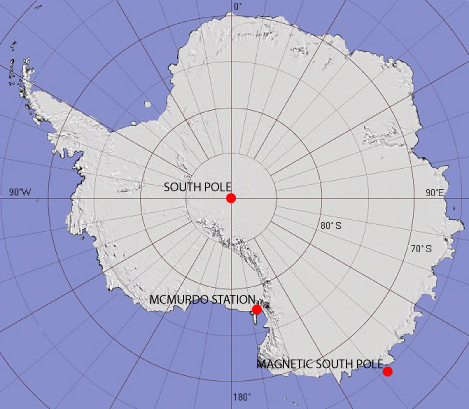 |
But you seem to have an obsession with the magnetic compass. They may have used one the early in the expedition,
but they had available an excellent natural compass!
All they needed was the sun and and an accurate clock, and they had a 24 hour sun!
Of course the final pole location was performed using sun altitude measurements.
The description of this process makes fascinating reading in Amundsen's report.
So the only way they actually knew they were at the South Pole was by looking at the sun and assuming that they were on a Round Earth. Got it.
Well yes I got that long ago - took you a while
(2)! But please tell me just how navigators from "time immemorial" have navigated the ocean!
The Vikings used the sun, and were reported to have been able to get a reasonable fix in even heavy overcast.
The early South Sea Islanders used the sun and stars (and clouds, birds, etc).
Captain and the earlier seafarers used the sun and stars (Celestial Navigation), though before the development of the Marine Chronometer Longitude was difficult to ascertain accurately! Look at all the early Spanish and Dutch wrecks on the Australian west coast, when the sailing directions from the Cape of Good hope were something like "Sail east for

days, then take a hard left!".
Yes, whatever the shape of the earth there is a sun that shines very predictably on Antarctica and the South Pole.
(1) TrueNorth on the Antarctica grid system is defined as the 0° Longitude Line through Greenwich
(2) If you don't see a need to admit to a South Pole, just why are you pushing the
Bi-Polar Map, with its Celestial Gears.