*

Offline Bobby Shafto

  • *
  • Posts: 1390
  • https://www.youtube.com/channel/UCdv72TaxoaafQr8WD
    • View Profile
    • Bobby Shafto YouTube Channel

Well, you were in error to quickly declare victory then. We can see that the matter was swarmed over in the comments section:
Before I read those comments, I have to wonder why you think that should stymie my declaration of victory (if that's what I did). Critical comments rebutting things you think are decisive have never stopped you. Do you hold me to a different standard than to which you hold yourself?

If the critical comments have to do with what you were saying about the horizon being uncertain and "fuzzy," I'll address that shortly. But take a look at the rebuttals and see if there's something else of substance that should be considered.

*

Offline Bobby Shafto

  • *
  • Posts: 1390
  • https://www.youtube.com/channel/UCdv72TaxoaafQr8WD
    • View Profile
    • Bobby Shafto YouTube Channel

Well, you were in error to quickly declare victory then. We can see that the matter was swarmed over in the comments section:

Quote
The error of your reasoning is that...

That critique (by YouTube account Maciej Jaros) was one of 2. The other (Flat Earth Genius) was a SHOUTING attempt , the content of which I trust you recognize was flawed.

But Andrew Eddie (the video publisher) offered an even-handed response to Maciej's commentary, and Maceij hasn't responded (yet).

So, that's no "swarm."

Also, Maciej's response is not the rationale of EnaG. It doesn't appear that he's read EnaG.

Which leads me to ask yet again, how do you know where the horizon is? How far away is it? Every time Rowbotham uses his explanation of perspective to explain the horizon or the effects thereon, he draws something like this:

See where the red upward sloping line ends and the blue flat line begins. That point is H. The horizon. How far away is that? If the red sloping line is always ends at eye-level and that's the edge beyond which all else converges beyond it on a flat plane coincident with eye level, that that ought to be calculate-able. Sure, it might be obscured by haze or fog or mist or smoke or smog or ash, but at some point you've got to be able to say "ah, there it is. It's the horizon and it's not rising anymore."

Where is that? How can you identify it. It's it totally subjective, like, if it's not at eye level then it must not be the horizon? (That would be quite circular and self-referential.)

Please, explain this. It's not clear to me at all from EnaG. (I did work out what I think might be the formula, based on the minimum angle Rowbotham said the eye can perceive, but I'm not sure and it didn't receive any response.)
« Last Edit: May 23, 2018, 06:45:29 AM by Bobby Shafto »

Offline Tontogary

  • *
  • Posts: 431
    • View Profile
So then if we can NEVER see a horizon, (because it is not at eye level, ever) how do people successfully calculate their position using the sun and stars at sea?

If there is not a clear horizon then we cannot take the altitude of the sun or stars to make our calculations.

Now if you know how how we do it, i would love to know what i have been doing wrong for the last 33 years.
Maybe you will enlighten me?

At altitudes near sea level where the earth's horizon is sharp, it may be at eye level per Earth Not a Globe's explanation of finite perspective lines. This has not been disproven.

We know that from an international flight the horizon is just a foggy mess.

At various other altitudes and atmospheric conditions, the situation is less clear; but you may keep trying. I can see in that video that it is not the clearest day.

Not good enough, sorry.

When measuring the altitude of a star, or sun or any other body we use for navigation, we dont do so from the sea level. We do it from the bridge of the ship, 30 40 or more metres up from the sea level.

40 metres up is over 130 feet to those who use out of date units.

The angle of dip at that height is 11.1 arc minutes. We need to account for this.

When taking a celestial observation we do it to the nearest 0.1 arc minute, as when we plot the position line, every arc minute in error is 1 mile in error.

Now supposing i take 3 star sights, and I have allowed for 11.1 arc minutes for correction of the observation due to dip, and it does not exist. EACH of my observations is now in error by over 11 miles, which can give me a 20 to 30 mile error in my final position.

Yet when i make the correct calculations ALLOWING for the dip of the horizon i can get a good accurate position. How is that Tom? Please explain it to me?

If the horizon is vague and hard to determine, then no one will be will be able to take accurate celestial (astronomical) observations. Every position found by astronomical observation, will be in error In proportion to the height that the observations were made.

This has never been documented.

Also, if you haven't heard of bronies before, that reflects poorly on your understanding of the world that surrounds you. It's practically impossible not to know about them.

*

Offline Bobby Shafto

  • *
  • Posts: 1390
  • https://www.youtube.com/channel/UCdv72TaxoaafQr8WD
    • View Profile
    • Bobby Shafto YouTube Channel
I can see in that video that it is not the clearest day.
It wasn't the clearest day today in San Diego either. But there was a horizon. Was it the "true" horizon? Allow me to walk you through this sighting of the Coronado Islands off of Mexico from San Diego's Point Loma.


The bottom image is part of a zoom sequence I took from a 380' vantage point looking south. The small island (circled in red) is the 100' Pilón de Azúcar (Pile of Sugar), 19.09 miles away from my view spot.

I figure (using globe earth rationale) that the "dip" from horizontal between my elevation and the elevation of the island's small summit was about -0.16°.


And the "dip" to the (globe) horizon, about 5 miles beyond Pilon de Azucar, is -0.17°


At no point, on a globe earth, can the horizon be seen above and behind Pilón de Azúcar, no matter how clear the view to the horizon. In fact, in 25 years living in San Diego, I've never seen the horizon rise up behind any of the off shore islands. Yet, from 380', if the horizon did always rise to eye level, I should see the ocean continue to slope upward to meet the level of the eye, and that would be above the elevation of the little "middle island" de Coronados.

But that just never happens.
« Last Edit: May 23, 2018, 07:02:31 AM by Bobby Shafto »

Offline edby

  • *
  • Posts: 1214
    • View Profile
From Proctor:
Quote
https://books.google.co.uk/books?id=uQknbHhq2TAC&pg=PT308 
Let a very small mirror (it need not be larger than a sixpence) be so suspended to a small support and so weighted that when left to itself it hangs with its face perfectly vertical—an arrangement which any competent optician will easily secure—and let a fine horizontal line or several horizontal lines be marked on the mirror; which, by the way, should be a metallic one, as its indications will then be altogether more trustworthy. This mirror can be put into the waistcoat pocket and conveniently carried to much greater height than the mirror used by Parallax. Now, at some considerable height—say five or six hundred feet above the sea-level, but a hundred or even fifty will suffice—look into this small mirror while facing the sea. The true horizon will then be seen to be visibly below the centre of the eye-pupil—visibly in this case because the horizontal line traced on the mirror can be made to coincide with the sea-horizon exactly, and will then be found not to coincide with the centre of the eye-pupil. Such an instrument could be readily made to show the distance of the sea-horizon, which at once determines the height of the observer above the sea-level. For this purpose all that would be necessary would be a means of placing the eye at some definite distance from the small mirror, and a fine vertical scale on the mirror to show the exact depression of the sea-horizon. For balloonists such an instrument would sometimes be useful, as showing the elevation independently of the barometer, whenever any portion of the sea-horizon was in view.

Offline edby

  • *
  • Posts: 1214
    • View Profile
At altitudes near sea level where the earth's horizon is sharp, it may be at eye level per Earth Not a Globe's explanation of finite perspective lines. This has not been disproven.
Can you point me to a clear explanation of what 'finite perspective lines' actually are. As I understand, the claim is that parallel lines can meet. But this is contradictory under the standard definition of 'parallel'. So the FE definition is different. What is the definition?

*

Offline AATW

  • *
  • Posts: 6499
    • View Profile
At altitudes near sea level where the earth's horizon is sharp, it may be at eye level per Earth Not a Globe's explanation of finite perspective lines. This has not been disproven.
Well, you can't disprove it experimentally, to do so involves experiments over infinite distances which are a bit tricky...
I disproved it in the other thread using geometry and common sense though. Photons coming from two parallel lines going away from you will meet at your eye at an angle. That angle depends on how far you look into the distance. But it's a triangle, your eye is one corner, the other two corners are the points you're looking at on the two parallel lines. At which point does the angle at your eye become zero? It has to be infinity. The distance between the lines remains constant, that's what parallel means. The only thing that changes is the distance you look so the angle gets smaller but never zero. Obviously way before infinity the angle will be too small for you to distinguish the two lines but that is a limit of your vision. Optical magnification will resolve them.

Quote
We know that from an international flight the horizon is just a foggy mess.
At various other altitudes and atmospheric conditions, the situation is less clear; but you may keep trying. I can see in that video that it is not the clearest day.

Actually, the round earth explanation of this is quite simple. You are looking over a curve and the horizon is simply where you see the edge of the earth - quite poetic when you think of it that way, but that is what you are seeing:


From this diagram you can see that the higher you are the further you can see over the curve. That is why the horizon is further away the higher you go. I don't know what the FE explanation of that would be, if in your world the horizon is merging perspective lines, why would the distance they do so vary with your altitude?

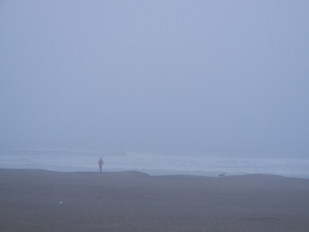
Whether the horizon is sharp simply depends on whether visibility is good enough to see as far as the horizon is, that is more likely to be at ground level because the horizon is not as far away, but on a foggy day the horizon won't be sharp at ground level either:


So yes, on a flight the horizon is often hard to see because the distance to the horizon at that height is often further than clear visibility - and you're above clouds which can obscure the horizon.

In the picture used in that video the horizon was sharp enough, there was no gradual fading out as there would be if the real horizon was actually further away.
Your objections really are getting increasingly desperate and is lending more weight to my theory that you don't believe any of this and just enjoy debating from an impossible position.
« Last Edit: May 23, 2018, 09:28:51 AM by AllAroundTheWorld »
Tom: "Claiming incredulity is a pretty bad argument. Calling it "insane" or "ridiculous" is not a good argument at all."

TFES Wiki Occam's Razor page, by Tom: "What's the simplest explanation; that NASA has successfully designed and invented never before seen rocket technologies from scratch which can accelerate 100 tons of matter to an escape velocity of 7 miles per second"

Offline edby

  • *
  • Posts: 1214
    • View Profile
Wouldn't concave refraction explain this? On the second stick man drawing with flat surface, suppose the light rays come down to touch the surface, then curve upwards gently to meet the eye. So it appears to stick man as though there is a visible horizon, whereas there really isn't.

However I am struggling to reconcile that idea with Tom's claims in another thread that mountain peaks really appear flat. I.e. if all the observations look as though the earth were round, even though it is really flat, why would Tom argue that the view of the mountains is consistent with flatness. One of these has to give.

*

Offline AATW

  • *
  • Posts: 6499
    • View Profile
Wouldn't concave refraction explain this? On the second stick man drawing with flat surface, suppose the light rays come down to touch the surface, then curve upwards gently to meet the eye. So it appears to stick man as though there is a visible horizon, whereas there really isn't.
Possibly in some conditions. I originally drew that to demonstrate that even if the earth were flat the horizon would dip - the red line is supposed to indicate the limit of visibility.

Quote
However I am struggling to reconcile that idea with Tom's claims in another thread that mountain peaks really appear flat. I.e. if all the observations look as though the earth were round, even though it is really flat, why would Tom argue that the view of the mountains is consistent with flatness. One of these has to give.
Tom often argues completely contradictory things depending on the circumstance, I find!
Tom: "Claiming incredulity is a pretty bad argument. Calling it "insane" or "ridiculous" is not a good argument at all."

TFES Wiki Occam's Razor page, by Tom: "What's the simplest explanation; that NASA has successfully designed and invented never before seen rocket technologies from scratch which can accelerate 100 tons of matter to an escape velocity of 7 miles per second"

*

Offline rabinoz

  • *
  • Posts: 1441
  • Just look South at the Stars
    • View Profile
Wouldn't concave refraction explain this? On the second stick man drawing with flat surface, suppose the light rays come down to touch the surface, then curve upwards gently to meet the eye. So it appears to stick man as though there is a visible horizon, whereas there really isn't.
Try this for size.
I believe that under the Electromagnetic Accelerator theory, in which light is universally bending upwards, the effect would have a side effect of the sun shining its same face over the entirety of the earth's surface. Extreme angles of the sun would be bent away from the observer and never seen.

Of course on the real earth light from the sun is usually bent down slightly, typically shout 0.6° at the horizon.
Quote from: AllAroundTheWorld
Possibly in some conditions. I originally drew that to demonstrate that even if the earth were flat the horizon would dip - the red line is supposed to indicate the limit of visibility.

Quote
However I am struggling to reconcile that idea with Tom's claims in another thread that mountain peaks really appear flat. I.e. if all the observations look as though the earth were round, even though it is really flat, why would Tom argue that the view of the mountains is consistent with flatness. One of these has to give.
Tom often argues completely contradictory things depending on the circumstance, I find!
That's an essential for belief in a flat earth, it's not problem for some.

*

Offline Bobby Shafto

  • *
  • Posts: 1390
  • https://www.youtube.com/channel/UCdv72TaxoaafQr8WD
    • View Profile
    • Bobby Shafto YouTube Channel

At altitudes near sea level where the earth's horizon is sharp, it may be at eye level per Earth Not a Globe's explanation of finite perspective lines. This has not been disproven.

We know that from an international flight the horizon is just a foggy mess.

At various other altitudes and atmospheric conditions, the situation is less clear; but you may keep trying. I can see in that video that it is not the clearest day.

These were taken at the same location (380' above sea level), viewing the Middle Islands of Islas de Coronado, about 20 miles away:


Yesterday evening was much clearer, but still hazy enough to maybe not qualify as a "sharp" horizon.
Today, the marine layer haze is thicker and definitely not a good horizon viewing day (currently).

Comparing the two images: in the sharper of the two you can more clearly make out a horizon line slightly higher than in the later, hazier one.

I can tell in the clearer one that the sea plane rises more behind the islands. I can't tell that in the hazier one, where the plane of the sea appears to end near the islands themselves.

The challenge/question is how clear is clear enough? At what point can we confidently say there will be no more rise in the horizon line with additional clarity? I know where that is in globe earth. But if I don't want to bias this with a globe earth premise, what is the flat earth criteria for knowing you are looking at a 'true" horizon?

For reference, the larger island on the left has summits near 400'. (Wikipedia is wrong, listing both islands as rising to only 100', which is true for the small one on the right but obviously not true for the one on the left.) Since my height was 380' (+/- 5') the summit of the large island is right about "eye level" in the picture. Will I only be seeing the "true horizon" if it matches with that summit? If so, then I don't think I've ever seen a "true" horizon.

Max_Almond

Wouldn't concave refraction explain this? On the second stick man drawing with flat surface, suppose the light rays come down to touch the surface, then curve upwards gently to meet the eye. So it appears to stick man as though there is a visible horizon, whereas there really isn't.

However I am struggling to reconcile that idea with Tom's claims in another thread that mountain peaks really appear flat. I.e. if all the observations look as though the earth were round, even though it is really flat, why would Tom argue that the view of the mountains is consistent with flatness. One of these has to give.

Is "concave refraction" a thing? I'm not sure we have to invent concepts to explain flat earth impossibilities: that's their job, surely. ;)

Likewise reconciling the various invented concepts that contradict one another.

Though each to their own. :)

Offline edby

  • *
  • Posts: 1214
    • View Profile
I have replaced this with my new theory that objects get larger as you travel south past the equator. Note: all objects. So you have a keyboard 18 inches long, and you have a ruler. You measure the keyboard at the equator, and you get 18 inches. Now as you travel further south, the keyboard gets larger and larger, but so does the ruler. So the keyboard always seems 18 inches long.

And of course you get bigger, the sea wider and so on. You never notice, but it really happens. So you get the illusion that lines of longitude are converging, when really they are diverging. So the Flat Earth theory is true, but you never notice it. You would only notice at the supposed ‘South Pole’, where all distances expand to infinity. We need to find this spot, assuming it’s safe.

Max_Almond

Brilliant! I love it!

Make a youtube video and I guarantee you'll have people genuinely following it and thinking it's true. :D

*

Offline Tom Bishop

  • Zetetic Council Member
  • **
  • Posts: 10665
  • Flat Earth Believer
    • View Profile

At altitudes near sea level where the earth's horizon is sharp, it may be at eye level per Earth Not a Globe's explanation of finite perspective lines. This has not been disproven.

We know that from an international flight the horizon is just a foggy mess.

At various other altitudes and atmospheric conditions, the situation is less clear; but you may keep trying. I can see in that video that it is not the clearest day.

These were taken at the same location (380' above sea level), viewing the Middle Islands of Islas de Coronado, about 20 miles away:


Yesterday evening was much clearer, but still hazy enough to maybe not qualify as a "sharp" horizon.
Today, the marine layer haze is thicker and definitely not a good horizon viewing day (currently).

Comparing the two images: in the sharper of the two you can more clearly make out a horizon line slightly higher than in the later, hazier one.

I can tell in the clearer one that the sea plane rises more behind the islands. I can't tell that in the hazier one, where the plane of the sea appears to end near the islands themselves.

The challenge/question is how clear is clear enough? At what point can we confidently say there will be no more rise in the horizon line with additional clarity? I know where that is in globe earth. But if I don't want to bias this with a globe earth premise, what is the flat earth criteria for knowing you are looking at a 'true" horizon?

For reference, the larger island on the left has summits near 400'. (Wikipedia is wrong, listing both islands as rising to only 100', which is true for the small one on the right but obviously not true for the one on the left.) Since my height was 380' (+/- 5') the summit of the large island is right about "eye level" in the picture. Will I only be seeing the "true horizon" if it matches with that summit? If so, then I don't think I've ever seen a "true" horizon.

Doesn't this lend credence to the idea that the state of the atmosphere in the distance can move the horizon down?

*

Offline Bobby Shafto

  • *
  • Posts: 1390
  • https://www.youtube.com/channel/UCdv72TaxoaafQr8WD
    • View Profile
    • Bobby Shafto YouTube Channel
Doesn't this lend credence to the idea that the state of the atmosphere in the distance can move the horizon down?
Yes. That's why I posted these. Atmospheric surface haze will push the apparent horizon "down" (aka closer).

But what about "up"? What's the "up" limit? (aka further).

How do you -- and I mean, you, Tom Bishop --  know if it's clear enough to make an "eye level" evaluation?

3 images of the middle Coronados, taken today:
(Surface inversion layer is evident in the first two, viewing close to the ocean's surface.)

1st from 10' above the water at https://goo.gl/maps/M6y1CHBsEWr.


2nd from 100' https://goo.gl/maps/RpC3aEEorms:


3rd from 400' https://goo.gl/maps/q6Sv2SuCGBD2:
« Last Edit: May 24, 2018, 04:11:17 AM by Bobby Shafto »

Offline Theo

  • *
  • Posts: 12
    • View Profile
1. Rowbotham discusses Theodolite Tangent here: http://www.sacred-texts.com/earth/za/za45.htm

6. Bobby personally performed this sort of water experiment himself and can tell you how sensitive and complex this seemingly simple experiment is. He decided to abandon it. Read his thread: https://forum.tfes.org/index.php?topic=9492.0

1. Rowbotham is only useful as an example of how to bamboozle simple folk with mindgames and twisted logic.

6. The water level equpiment is more than accurate enough for purpose.

Bobby's thread chronicles his journey and the issues faced. It is not a simple experiment.

Surveying is not easy. It is incredibly difficult and sensitive.

Surveying is always in error. Always. The device needs to be finely aligned, positioned, and calibrated. Even then, there is still inherent error.

http://whistleralley.com/surveying/theoerror/

Quote
As any surveyor should understand, all measurements are in error. We try to minimize error and calculate reasonable tolerances, but error will always be there. Not occasionally; not frequently; always. In the interest of more accurate measurements, we look for better instruments and better procedures.

The greater the distance you are trying to align your devices with, the greater the potential error. All devices need to be of superior calibration.

...


You forgot this part from the website you quote mined...

Quote
One major design improvement came with the invention of the transiting theodolite. With this innovation, the telescope was able to swing all the way over on the trunnion axis. This in itself did not reduce any of the inherent error in the instrument, but it gave surveyors the means of doing so. When the scope is inverted, the instrument error is still there, but most of the error reverses direction. By taking the mean of an even number of observations, half direct and half inverted, the error is turned against itself and greatly reduced.

And this:

Quote
The theodolite actually has one advantage over most levels. By inverting the telescope, the collimation can be checked from a single setup.

And this:

Quote
A few seconds, or even minutes, of error here makes no appreciable difference in horizontal distances, but it can play all havoc with elevations. Unlike the horizontal angle errors, this one is constant, which is to say, it is not affected by changes in the direction of the sight. That makes it a fairly simple matter to correct the angle without even adjusting the instrument. In fact, electronic instruments typically have an onboard routine that will measure and correct the vertical angle error. Push a few buttons, sight a target in both positions, and have the instrument store the correction. The procedure takes only a couple of minutes, so it can be done at the beginning of each work day.

In other words just like a carpenter will flip his level to insure accuracy surveyors do the same with theodolites. 
There can be errors in surveying, but elevation of the horizon is child's play and any instrument error is turned upon itself.  A theodolite is more than accurate enough to determine that the horizon is ALWAYS below the horizontal tangent.
Even a cheap builder's level is accurate to 1/16"/100'.  A good theodolite will will be accurate to 1mm/Km.
To say that one can't be trusted to measure the dip of the horizon is ludicrous at best.