Did you notice the size difference between Thork's picture and yours?
Did you research the advancement of the technology and time line?
As technology and techniques improved/improves the size of the receiving dishes decreased/will decrease and data rates have/will increase.
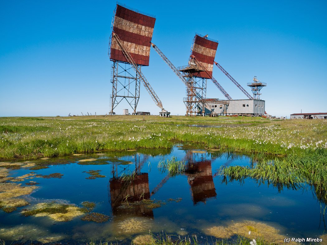
Looking closer you should realize the antennas currently used for troposcatter are much larger so they can receive the signal than the antennas used for satellite TV. They used to need to be
Militaries are interested in troposcatter because of the narrow transmission beam. It allows for more security because the signal can be directed and have a very narrow range where it can be intercepted. Compare that to satellite transmissions which can be received over a very large area.
That would be a pretty dumb military application if any military operation which uses it has to be located in line with where the transmitter is pointing. How does that work? A lot of those military broadcasting antennas don't even look like they turn. And then in a combat situation how does it work when there are multiple teams spread across a large battle field trying to communicate with toposcatter tech?
I think it is more likely operates like a spotlight in the sky that anyone can see.
Look, I spent literally 2 minutes researching the matter and proved you wrong that Troposcatter tech worked only in a line like you described and is more like a spotlight in the sky that anyone can see:
http://www.comtechsystems.com/wp-content/uploads/2014/05/Troposcatter-In-The-Modern-Military.pdf
In an attempt to free-up satellite bandwidth, ground forces increased the use of Line-Of-Sight
microwave equipment. While useful, the problem in many instances was that LOS required
multiple relays to maneuver around obstacles or to span distances greater than the limited range
of tactical LOS links. This in turn resulted in relays being installed in unsecured areas that
required force protection and had no supporting infrastructure, thus limiting the use of LOS as a
complete battlefield bandwidth solution.
As an alternative to LOS and satellite, the military deployed its aging fleet of AN/TRC-170
troposcatter systems to provide intra theater communications. These vehicle mounted systems
with trailer transported antennas were the main stays of tactical long haul communications from
the 1970s through the early 1990s. One of the largest deployed troposcatter networks was
established using the AN/TRC-170 during Operation Desert Storm, consisting of over 60 links.
The success of mobile troposcatter systems in Operation Enduring Freedom (OEF) and
Operation Iraqi Freedom (OIF) substantiated the value of troposcatter communications on the
modern battlefield.
Do you notice the size difference? Do you notice the troposcatter antenna is actually two antennas since it increased the reliability?
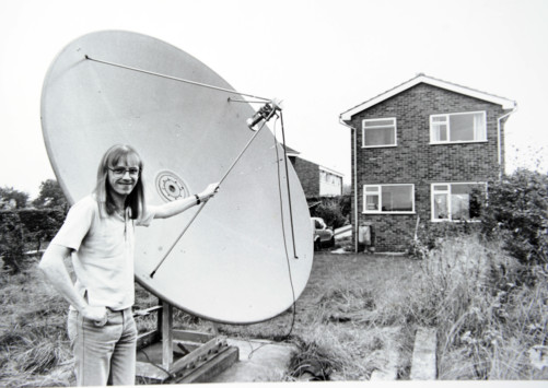
As I pointed out we now live in a time where they reduced the sizes, increased data rate and reliability. This did not happen when satellite transmissions where first used to send signals to people's homes.
Satellite dishes on people's homes also used to be a lot bigger. It looks like as Troposcatter antennas shrunk so did the dishes on people's homes.
Antennas used for troposcatter still need to be larger than the ones used for satellite transmissions since the signal is still weaker and atmospheric conditions have a greater influence on them.
Home satellite dish connections are also subject to atmospheric conditions. What are you trying to tell us?
Well having being in long range surveillance as the radio operator where I had to send transmissions with satellites and other radios across the globe I think differently and so does the military. The most secure and hardest to detect was not the satellite radio I used. It was a a radio using a directional antenna. Proven in training when intelligence units where trying to detect and track my team.
It is harder to detect a signal sent only in one direction. It does not work like a spot light in the sky, do more research. It is a directional signal being sent. I was in the military in intelligence units using this technology and trained how to use it. If the antenna's direction and elevation is off by a rather small margin depending on weather no signal is received.
Here is the very important part. The sat-com antenna I used fit in my rucksack. The antenna for troposcatter was mounted on a truck. Again need a large antenna to increase reliability and because the signal strength is much weaker.
Troposcatter transmissions are effected more by atmospheric conditions than satellite signals. Like how humid it is, where a satellite signal generally needs really bad weather and thick cloud cover to be effected.
I read your link where did it say I was wrong? troposcatter communications is directional and harder to intercept. It is one reason the military is interested in advancing the technology.
Again I pointed out like a lot of stuff size is decreasing, amount of data and reliability is increasing. Troposcatter antenna are still not carried by soldiers, but on trucks and trailers. Troposcatter antennas need to be larger than a satellite antenna with the current technology we have.
So I literally spent less than a minute reading what you said prove me wrong. It does not.
Keep in mind I used this equipment in real world conditions. Troposcatter is not sending satellite signals are being used for GPS. With current technology we would need to go back to the 80's size satellite dishes. Not only that satellite dishes would not all be pointing in the same direction across some place like North America. We would also be seeing a lot more dishes around since the effective range of troposcatter transmissions is around 250km. It can be around 300km depending on amount of data needed to be transmitted, atmospheric conditions and terrain. Older systems like the one from 1963 had further ranges, but as you see those antennas where rather large and not mobile.