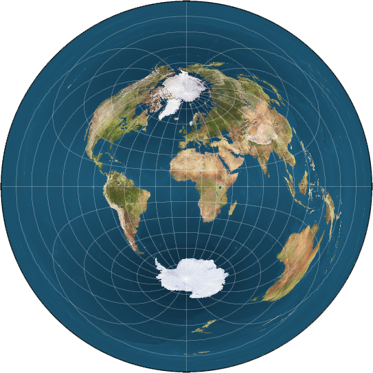
I'm curious, as I've been looking at a map of a bi-polar model and cannot quite wrap my head around how the sun would move over this version of the Earth's surface. Any diagrams or explanations?
The sun's observed path is pretty well-known, and I think that typical FE sun paths are derived by taking the position at lanai noon and assuming that the sun must be exactly where it appears to be (straight over the viewer's head) at that point. So I suggest you pick a date and plot the location of the sun at lanai noon for that date. The equinox is the easiest, so that's where I would start. Sept 22, 2018 is the next equinox. During the equinox, the sun should remain directly over the equator. That should make its path quite easy. With these assumptions, the path of the sun is to travel along the equator in an east-to-west circuit. So simply draw that on your bi-polar map. On the bi-polar map I'm looking at, that means the sun starts out in the pacific ocean, travels over indonesia, africa, south america, and then back out into the pacific. At that point, the sun pulls a pac-man and reappears on the other side of the map again.
Next, you might want to do the winter solstice when the sun is assumed to travel along the tropic of capricorn. So just trace the line of 23 degrees south along the map from east to west. The tropic of capricorn looks like a squashed oval on my bi-polar map. So we'll start with the sun out past australia. The sun moves over australia, then africa, south america, and then out into the pacific. This time it doesn't need to pac-man, it just curls down back around in a big circle going around antarctica back to where it started past australia.
As you chart the course of the sun, take note of when it is at each location. The bi-polar map I'm looking at makes it pretty easy because it as the lines of longitude drawn on it. We know the sun crosses these at an even pace. This map has those lines every 15 degrees, so the sun should cross one of these each hour. That means as the sun is crossing through the middle, it's moving at a pretty steady pace. But then as it gets out west, it starts to speed up. Then as it turns to head around the southern loop, it's really bookin'. Finally is slows down again as it starts to turn northward. If you try this at a few other times of the year, you'll see that the sun's acceleration pattern changes slightly each day. On the equinox, the sun is actually holding a very steady pace all day right up until it needs to pull that pac-man maneuver. Possibly we could imagine that rather than literally pac-manning, the sun has to go around one loop or the other - just really really fast - making the loop back over the half-circle in 1 hour.
That's pretty much it. Depending on the time of year, the sun either makes a loop up north, a loop down south, or a straight-line over the top of the map with a pac-man to pop over to the other side.
All of this is making some pretty significant assumptions.
1) We assumed the shape of the map.
2) We assumed that the sun is where it appears to be at lanai noon (when it's straight overhead)
Here's the bi-polar map I was referencing for this: