Show Posts

This section allows you to view all posts made by this member. Note that you can only see posts made in areas you currently have access to.


Messages - Tom Bishop

Pages: < Back  1 ... 419 420 [421] 422 423 ... 491  Next >
8401
Flat Earth Community / Re: Satellites.... Troposcatter Technology?
« on: September 14, 2016, 08:48:02 AM »

Did you notice the size difference between Thork's picture and yours?

Did you research the advancement of the technology and time line?

As technology and techniques improved/improves the size of the receiving dishes decreased/will decrease and data rates have/will increase.

Looking closer you should realize the antennas currently used for troposcatter are much larger so they can receive the signal than the antennas used for satellite TV. They used to need to be

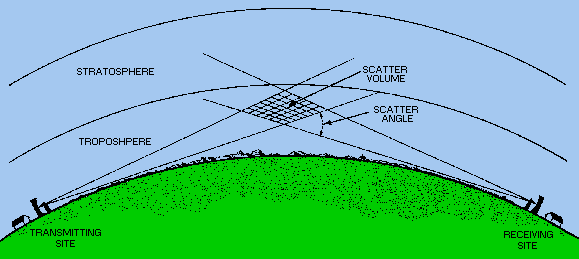
Militaries are interested in troposcatter because of the narrow transmission beam.  It allows for more security because the signal can be directed and have a very narrow range where it can be intercepted.  Compare that to satellite transmissions which can be received over a very large area.

That would be a pretty dumb military application if any military operation which uses it has to be located in line with where the transmitter is pointing. How does that work? A lot of those military broadcasting antennas don't even look like they turn. And then in a combat situation how does it work when there are multiple teams spread across a large battle field trying to communicate with toposcatter tech?

I think it more likely operates like a spotlight in the sky that anyone can see.

The following article seems to suggest that Troposcatter was introduced because the military didn't like having their current communication setup using microwave transmitters which required multiple transmitters and the field teams to be in a line with the antenna. It appears that they were able to replace multiple microwave transmitters with one Troposcatter transmitter. That sounds to me like it's broadcasting a spotlight in the sky that anyone can see and communicate with.

From http://www.comtechsystems.com/wp-content/uploads/2014/05/Troposcatter-In-The-Modern-Military.pdf

Quote
In an attempt to free-up satellite bandwidth, ground forces increased the use of Line-Of-Sight
microwave equipment. While useful, the problem in many instances was that LOS required
multiple relays to maneuver around obstacles or to span distances greater than the limited range
of tactical LOS links. This in turn resulted in relays being installed in unsecured areas that
required force protection and had no supporting infrastructure, thus limiting the use of LOS as a
complete battlefield bandwidth solution.

As an alternative to LOS and satellite, the military deployed its aging fleet of AN/TRC-170
troposcatter systems to provide intra theater communications. These vehicle mounted systems
with trailer transported antennas were the main stays of tactical long haul communications from
the 1970s through the early 1990s. One of the largest deployed troposcatter networks was
established using the AN/TRC-170 during Operation Desert Storm, consisting of over 60 links.
The success of mobile troposcatter systems in Operation Enduring Freedom (OEF) and
Operation Iraqi Freedom (OIF) substantiated the value of troposcatter communications on the
modern battlefield.

Quote from: woody
Do you notice the size difference? Do you notice the troposcatter antenna is actually two antennas since it increased the reliability?
As I pointed out we now live in a time where they reduced the sizes, increased data rate and reliability.  This did not happen when satellite transmissions where first used to send signals to people's homes.

Satellite dishes on people's homes also used to be a lot bigger. It looks like as Troposcatter antennas shrunk so did the dishes on people's homes.

Quote from: woody
Antennas used for troposcatter still need to be larger than the ones used for satellite transmissions since the signal is still weaker and atmospheric conditions have a greater influence on them.

Home satellite dish connections are also subject to atmospheric conditions. What are you trying to tell us?

8402
The above experiment is only applicable if the water is standing or frozen, and shows that the horizon is at eye level. However, if there are waves, Rowbotham shows that the calm or rough nature of the waves affects when the sun rises:

Quote
The above remarks are made considering the water to be water to be still, as if it were frozen; but as the water of the sea is always in a state of undulation, it is evident that a line of sight passing over a sea horizon cannot possibly continue mathematically parallel to the plane of the water, but must have a minute inclination upwards in the direction of the zenith. Hence it is that often, when the sun is setting over a stormy or heavily swelling sea, the phenomenon of sunset begins at a point on the horizon sensibly less than 90° from the zenith. The same phenomenon may be observed at sunrise, from any eminence over the sea in an easterly direction, as from the summit

p. 275

of the Hill of Howth, and the rock called "Ireland's Eye," near Dublin, looking to the east over Liverpool Bay, in the direction of the coast of Lancashire. This is illustrated by diagram 97:----


FIG. 97.

A, D, B, represents the horizontal surface of the sea, and D 1, and D 2, the optical or apparent ascent of the water towards the eye-lines O 1, and O 2; O, D, the observer; Z, the zenith; H, H, the horizon; and S, S, the morning and evening sun. It is obvious from this diagram that if the water had a fixed character, as when frozen, the angle Z, O 1, or Z, O 2, would be one of 90 °; but on account of the waves and breakers at the horizon H, H, mounting half their altitudes above the lines O 1, and O 2, the line of sight meets the sun .at S, which appears to rise or set on the elevated horizon H, the angle Z, O, S, being less than 90°.

This is evidently the cause of the sun setting and rising at sea, later when the water is calm, and earlier when it is greatly disturbed--a fact well known to observant sea-going travellers and residents on eastern or western shores. It is also the cause of the sun rising later and setting earlier than it would over a smooth plane of earth, or over absolutely still water, or than it ought to do mathematically for its known altitude.

8403
Quote from: rabinoz
It is far more accurate to say "that perspective causes the surface appear to ascend in height until the horizon appears to be almost at eye level to the observer."
When standing
on the seashore with the eye-level about 5' above sea-level, the horizon is about 3.2 miles away and about 10' below eye-level, but 10' in 3.2 miles is only about 2' of arc.
but when on a 1000' mountain,  the horizon is about 45 miles away and about 10' below eye-level, now 2,000' in 45 miles is only about 29' of arc, not noticeable, but quite measurable.

An yes, this "dip angle to the horizon" is real, and quite easily measured. Al Biruni measured the radius by measuring the dip angle to the horizon as in Al-Biruni's Classic Experiment: How to Calculate the Radius of the Earth?

I gave an extract from that site in Re: Total area of Earth, but it would be better to read the original.
This reference gives a critical review of Al Biruni's work, including putting realistic estimates on his methods and accuracy in the light of modern knowledge:

AL BASAIR ISLAMIC MEDIA, AL BIRUNI’S MEASUREMENT ON THE EARTH


This video shows measurements of the dip angle to the horizon up as far as 30,000 ft. I would prefer better equipment, but at 30,000 ft it is quite substantial.
https://youtu.be/2-vRzQ_GDV0
Flat Earth Debunked: The Horizon Always at Eye Level

Simply claiming, without evidence, "that the line of the horizon is always at eye level with the observer." is not correct.

But, even if it was. It has nothing to do with the case. At sunset, the eye is at near enough to the same level as the horizon, give or take a few feet, but the sun is still 3,200 miles about your horizon!

According to Rowbotham's Law of Perspective that 3,200 miles subtends an angle at the eye of around 20° (depending on where the observer is).[/i

Samuel Birley Rowbotham talks about Theodolite experiments in the chapter Tangential Horizon. It was found that using devices with lenses changes the true position of the horizon. The Tangential Horizon chapter invalidates your Thodolite experiments and Youtube video of a man who is using a device with lenses to determine the angle of the horizon.

Furthermore, in the video, the man is apparently using a free-to-download Theodolite app on his iPhone, so the results of his experiment are questionable. How does the phone know that it is spatially positioned exactly vertical and horizontal, for example? Are we expected to believe that iPhones are known for their great accuracy in surveying? Not very encouraging.

Rowbotham provides a more practical experiment without the imprecision of lenses which showed that there was no dip to the horizon:

Quote
In the following diagram, fig. 96:---


 FIG. 96.
FIG. 96.

Let A, B, represent a plane surface--say several miles over the sea, from the shore, and E, an observer's eye. It is evident that on looking directly downwards, as from E to A, the real and the apparent position of the water-surface will be the same. But if a transparent screen or a plate of glass be erected at some distance from the eye, as at C, D, and the sight be directed over the water to the distance W, the line of sight will cut the screen C, D, at the point 1, and the surface of the water will appear at 3, equal to the altitude of 1. If the sight

p. 274

is now directed to the point X, the line of sight, E, X, will cut the screen C, D, at the point 2, and the surface of the water will appear to be elevated to the point 4. It is evident, then, that the line of sight may be directed further and further over the water beyond X, and each further line of sight would cut the screen nearer to the line E, C, H, but could never become perfectly parallel with it. In the same way the surface of the water would appear nearer and nearer to the line E, H, at H, but could never come in actual contact with it: the angle H, E, X, becomes more and more acute as the distance increases; but, mathematically, the lines E, X, E, H, might be prolonged ad infinitum, the angle C, E, 2, infinitely acute, and the space H, 4, between the surface of the wafer and the line E, H, immeasurably small, but actual contact is mathematically impossible. Although there is always, at great distances, a minute space between the line of sight and the surface of the water at the horizon, still, for all practical purposes, and to the naked eye, there is no dip required.

8404
Flat Earth Community / Re: Satellites.... Troposcatter Technology?
« on: September 14, 2016, 03:20:43 AM »
Have a look at

Quote from: Wikipedia
Offset dish antenna
Main types of parabolic antennas
An off-axis or offset dish antenna is a type of parabolic antenna. It is so called because the antenna feed is offset to the side of the reflector, in contrast to the common front-fed parabolic antenna where the feed is in front of the dish, on its axis. As in a front-fed parabolic dish, the feed is located at the focal point of the reflector, but the reflector is an asymmetric segment of a paraboloid, so the focus is located to the side.
The purpose of this design is to move the feed antenna and its supports out of the path of the incoming radio waves. In an ordinary front-fed dish antenna, the feed structure and its supports are located in the path of the incoming beam of radio waves, partially obstructing them, casting a "shadow" on the dish, reducing the radio power received. In technical terms this reduces the aperture efficiency of the antenna, reducing its gain. In the offset design, the feed is positioned outside the area of the beam, usually below it on a boom sticking out from the bottom edge of the dish. The beam axis of the antenna, the axis of the incoming or outgoing radio waves, is skewed at an angle to the plane of the dish mouth.
The design is most widely used for small parabolic antennas or "mini-dishes", such as common Ku band home satellite television dishes, where the feed structure is large enough in relation to the dish to block a significant proportion of the signal. Another application is on satellites, particularly the direct broadcast satellites which use parabolic dishes to beam television signals to homes on Earth. Because of the limited transmitter power provided by their solar cells, satellite antennas must function as efficiently as possible. The offset design is also widely used in radar antennas. These must collect as much signal as possible in order to detect faint return signals from faraway targets.
Offset dish antennas are more difficult to design than front-fed antennas because the dish is an asymmetric segment of a paraboloid with different curvatures in the two axes. Before the 1970s offset designs were mostly limited to radar antennas, which required asymmetric reflectors anyway to create shaped beams. The advent in the 1970s of computer design tools which could easily calculate the radiation pattern of offset dishes has removed this limitation, and efficient offset designs are being used more and more widely in recent years.
   

I don't know about that. Look at these troposphere dishes with off-center receivers:

From http://web.archive.org/web/20090528134258/http://www.gdsatcom.com/troposcatter.php


Caption: "SATCOM Technologies’ newest addition to the troposcatter product line is the Dual-mode, All-band, Relocatable, Tactical Terminal (DART-T). Using industry-first technologies, this complete troposcatter system outperforms previous generations with its higher data rates, field-adaptable all-band operation, low weight and reduced prime power usage. Its patent-pending dual beam Ku-band feed uses angle diversity to achieve very low bit error rate in a small footprint terminal, replacing previous generations of troposcatter systems which were forced to rely on dual antennas on each end of the tropo link to achieve the necessary signal diversity. As a result, the number of antennas required for successful troposcatter operation is halved, freeing up valuable manpower and resources in the field."

Then there's this one from a page titled "SATCOM Technologies Troposcatter Communications System"

http://www.gdsatcom.com/email/1-10-08.htm


Compared to one of Thork's Satellite Dish images:


8405
Flat Earth Theory / Re: Opposite theory of gravity
« on: September 13, 2016, 11:47:13 PM »
Quote
First off, why are you instantly characterizing A as ignorant and biased?

He is ignorant because his science was replaced with Science B. He is biased because he is a Science A proponent rather than an an unaffiliated third party.

Quote
Second, we are talking about replacing a theory in the same discipline. Someone from another discipline is not as likely to replace a theory because they would not have the facility with the available evidence.

Earth Science covers all aspects of the planet from the deep inner core to the outer layers of the atmosphere. But Geology and Meteorology are called different sciences, as are sub fields within them. A science is merely a body of knowledge on a particular subject.

Quote
You really shouldn't talk about this because you often characterize scientists as biased and/or unable to just do the work of science, which is to follow the evidence.  It was Einstein who supplanted Newton, and it was Feynman who replaced Maxwell. These are scientists who were more than capable of seeing outside the box of what had come before and to find new and novel ways of dealing describing the world.

That's right. It was Einstein who debunked Newton, not Newton who debunked Newton.

It took a different scientist, who promoted a fundamentally different approach to the science, for science to change.

Quote
This blogger you linked to seems highly unlikely to supplant QM because he does not appear to be actually doing science, but instead puts up diagrams and ideas and purports them to be science.

His website is quite extensive and the theory is flushed out beyond the front page, do pay attention to things when you look at them.

Quote
The people actually doing science are the ones likely to do the science that supplants an outdated or outmoded theory.  This should not be a surprise.

The author claims to have discovered the protron and neutron wave structure in 2004. How is he not claiming to have performed science?

8406
What "stuff" is on the horizon, exactly?  Oh, you mean the ocean?  The flat, self levelling, ocean?  The ocean with (in these photos) tiny little waves on it?  Is that the "stuff" hiding tall objects?

You keep repeating the "elephant behind a dime" analogy, you must think it's effective.   ??? I don't understand why you think so. ???  If you stand a dime up on the ground a long ways off, the elephant cannot hide behind it no matter how far away he is.  As you yourself have told us:
The simplest explanation is that the photons simply traveled in a straight line.
However, in order for light from a tall animal like an elephant to hide behind a small object like a dime, the light would have to violate your rule, and instead dip down to dime level before rising again to eye level.  Same with tall objects (like cruise ships, skyscrapers, and storage tanks) and waves; in order for a wave located a mile away from me to hide from my sight a cruise ship a hundred feet or more above the surface, the light must curve.

Yes, but if you look out at the world you will notice that perspective causes the surface to ascend in height until the horizon is at eye level with the observer. And if you were to take a protractor you could see that the horizon is at a 90 degree angle to the ground.

From http://wiki.tfes.org/Basic_Perspective -

Quote
A fact of basic perspective is that the line of the horizon is always at eye level with the observer. This will help us understand how viewing distance works, in addition to the sinking ship effect.

Have you ever noticed that as you climb a mountain the line of the horizon seems to rise with you? This is because the vanishing point is always at eye level with the observer. This is a very basic property of perspective. From a plane or a mountain, however high you ascend - the horizon will rise to your eye level. The next time you climb in altitude study the horizon closely and observe as it rises with your eye level. The horizon will continue to rise with altitude, at eye level with the observer, until there is no more land to see.

Here's a text about horizon line and eye level, from Chapter 5 from the Perspective Handbook:

Anyone who has ever been to the seaside will have seen a horizon (as long as it wasn't foggy). This is the line you see far away, out to sea. It's the line where the water stops and the sky starts. There are horizon lines everywhere, but usually you don't see them because something like a hill or a tree or a house is in the way.

You always see the horizon line at your eye level. In fact, if you change your eye level (by standing up, or sitting down) the horizon line changes too, and follows your eye level. Your eye level always follows you around everywhere because it's your eye level. If you sit on the floor the horizon is at your eye level. If you stand up, it's at your eye level. If you stand on top of a very tall building, or look out of the window of an aeroplane, the horizon is still at your eye level.

It's only everything else that appears to change in relation to your eye level. The fact is, that everything looks the way it does from your point of view because you see it in relation to yourself. So if you are sitting looking out of the window of an airliner everything is going to look shorter than you because at this moment you are taller (or higher) than everything else.


One easy experiment you can do for yourself is find a computer game which can render large 3D maps. Move your character to one end of the map, center your crosshair on the line of the horizon, and turn on noclip. Without moving the mouse, ascend in height and notice how the line of the horizon will stay centered on the crosshair until you run out of land to see.

While a game is not comparable to life, this easily observable perspective effect is enough to satisfy the observer as to its workings and should be apparent and visible in most modern computer games.

8407
But,
1. The sun sets every night and at a very predictable time. Are you really going to claim that every night everywhere there just ahppens to be a convenient object to hide the sun?

There are always waves and swells on the surface of the sea, hundreds of them, thousands of them, so many that at the horizon they become a solid line, unable to distinguish. Of course there is always something to hide behind.

Quote
2. There is no way that a sun some 3,200 miles high can get to anywhere near the horizon! Remember Rowbotham's Law of Perspective!

You have not yet debunked the video I provided which shows that the geometrical side view math is not accurate.

Quote
Yes, I have read and studied that, but there is no way that "known magnification due the glare . . . . . . " explains the sin's staying exactly the same size!

Sure it does. The explanations and supporting evidence is pretty clear.

8408
Flat Earth Theory / Re: Opposite theory of gravity
« on: September 13, 2016, 07:26:31 PM »
The most qualified person to replace a scientific theory in an given discipline with another scientific theory is a scientist in the given discipline, obviously.

Quite incorrect.

If Science A is to be replaced with Science B it makes a lot more sense that someone who is very knowledgeable and practiced in Science B would do it, not an ignorant and biased Science A proponent.

8409
No that video is wrong!

Compelling.

Well, you asked for it. This is what I mean.
Obviously you will explain it away, but I find it compelling because it agrees exactly with what I expect to see.Horizon Zoom Boom Earth Flat Video


And that sun at sunset and these other buildings (from a Flat Earth video) certainly look further than the horizon, yet are very visible.

As Rowbotham clearly states, the vanishing point for an object depends entirely on the size of the object - large objects can be seen when much away.

To me that ship, those buildings and those tanks certainly are further away than the visible horizon an none are at anywhere near their vanishing point.

That would be because there is stuff on the horizon to hide behind, if an object is far enough away behind it, just as a dime can obscure an elephant. The plane of the earth is not perfectly flat.

Quote
That is why I claim that the video is wrong. It tries to show that the size of the should gradually reduce until it finally reduces to nothing at the horizon.

It does not do that! I did not want to clutter things up with this, but these are photos taken through a filter to remove the glare.

But from actual observations the angular size the sun does not change during the day. It certainly does not reduce in size as your video claims.
Have a look at this thread The Constancy of the Angular size of the Sun.
Here is a bit of the OP:
Now on Youtube there is a video made by a the Flat Earther, Matrix Decode with very good photos of the sun through a filter (an arc welder's glass) showing the sun at a number of times of day from 9:30 AM to 7:00 PM on 9/March/2016 in Malaga, Spain.

The following screen shots from his video does an excellent job of proving that the sun size does not change!

Do I need to say more? Our kind Flat Earther, Matrix Decode, has said it all!

The "sun does not appear to change its size until just before sunset" - a then only a little in height!


The size of the sun at sunset is described here: http://wiki.tfes.org/Magnification_of_the_Sun_at_Sunset

8410
Flat Earth Theory / Re: Opposite theory of gravity
« on: September 13, 2016, 06:31:50 PM »
Cool thing about astrology, as with FET, is that neither is founded in any type of science nor does either have any rules of constraint and any individual can produce a narrative which is pleasing to them.  What about you and your chosen narrative of FET makes you, decidedly, a reliable source?

Whether the subject matter is Astrology or Quantum Theory, it doesn't matter. The professionals in that field are in the best position to debunk other fields or to show his or her own field to be correct. The professionals in those fields are not in the best position to show his or herself to be wrong, however.

A Quantum Theorist probably isn't looking to prove that quantum particles or any type of matter doesn't actually exist, as that is counter to almost everything basic and fundamental about QM, everything he or she has learned, and all of his or her own published works.

The Wave-Matter Theory guy in that above link who says that QM is wrong is in the best position to prove QM to be wrong, as he knows the most about his subject and has written the most about it and has done most of the research. Being the most reliable source on that subject, he is also in the best position to prove himself to be correct.

8411
Flat Earth Theory / Re: Opposite theory of gravity
« on: September 13, 2016, 04:29:48 AM »
It also makes you absolutely unreliable as a source for FET.

Are Astrologers not reliable sources for the practice and teachings of Astrology?

Are they not the most reliable source to find and present evidence for it, if such evidence can exist?

For example, perhaps only an properly motivated Astrologer would be up on the statistics of the number of murders on full moons, and might argue that is possible for the celestial bodies to affect the human complexion. Maybe such a dedicated Astrologer would have all sorts of stats for us about the sun and the planets and the heavens. I only know about the murders during a full moon association. A knowledged Astrologer would know much more.

The Astrologer is not in the best position to debunk himself, as he is not actively persuing that, but he is in the best position to show himself to be right or the opposition to be wrong.

8413
That math doesn't really work when it comes to perspective. I refer you to the following video:


8414
Flat Earth Community / Re: Satellites.... Troposcatter Technology?
« on: September 13, 2016, 12:22:12 AM »
Where are you seeing that he got no satellite phone reception on a mountaintop?  Are you seriously basing it on a youtubers opinion on a Hollywood interpretation of a true story?  I hope you are, because that would be hilarious.

I've read about the Lone Survivor story and the youtuber's point appears to be correct as far as I can tell. The events take place in multiple locations. I haven't picked up the book, but you are welcome to read the book and settle the matter.

8415
Flat Earth Community / Re: Satellites.... Troposcatter Technology?
« on: September 12, 2016, 03:44:51 PM »
- In Lone Survivor, a true story, a major plot point is that the team's Satellite Phone got zero signal on the top of a mountain in Afganistan.
While I have neither watched the movie nor read the book Lone Survivor, I do have Google.  A quick search of the internet does not back up your assertion of "zero signal" at the top of a mountain.  It actually contradicts you exactly: the ONLY place he had signal was the very exposed position on top of the mountain, where he successfully made the call (and received his fatal wounds in the process)

Actually, if one searches for Satellite Phone on that page it says that he had to move to an "exposed position" to get a signal. It says nothing about it being on a mountain. From what I've read about it, I don't think the entire story takes place on the top of a mountain.

8416
Flat Earth Theory / Re: Opposite theory of gravity
« on: September 12, 2016, 03:33:26 PM »
In fact, Jefferson (or really any intelligent person) would be a far more reliable source than the people who fell for it hook, line, and sinker.

Such an ironic thing for you to say.  From all accounts you've fallen for FE hook, line and sinker.  Seems that puts you directly in the unreliable camp.

And that makes me the most reliable person to debunk RET, but perhaps not the most reliable person to debunk FET.

8417
Flat Earth Theory / Re: Opposite theory of gravity
« on: September 12, 2016, 08:50:56 AM »
Sandokhan is welcome to make additions to the Wiki with his model, but the theory will need to be readily understood by all and heavily debated before the majority adopt that as their model.

I base my arguments in favor of UA on that it is the most empirical explanation for gravity, which I have discussed elsewhere. However, his explanation may provide some talking points in its favor.

Your "Don't stop the quest to measure Big G" article isn't very specific on what the 0.05% spread in results means. Does it mean that they experiments got bunch of errors that were 25%, 25.05%m and 25.1% off, so we have a 0.05% spread in error? It doesn't even say what the experiments are looking at. They could be about looking at orbits in the sky being imprecisely measured by 0.05% for all we know, not a Cavendish-type experiment. Maybe these experiments are just examining falling bodies, and assuming that it's due to gravity, with the accuracy of the experiments being 0.05% off. We really have no idea what that vague phrase means in that zero source article.

8418
Flat Earth Community / Re: Satellites.... Troposcatter Technology?
« on: September 12, 2016, 08:21:05 AM »
Thork's post at https://www.theflatearthsociety.org/forum/index.php?topic=51208.msg1254456#msg1254456

I have a satellite dish on my house. It points South East, not up. Proof in itself the 'satellite' must be in Slough and not in space.

Your satellite dish points parallel to the surface of the earth?  ???
Yep. It is mounted like this one


or this one


or any of the ones in this street.


You'll be telling me they are all pointing up at satellites in the sky, and not parallel at ground based stations next. ::)

8419
Flat Earth Community / Re: Satellites.... Troposcatter Technology?
« on: September 12, 2016, 07:47:39 AM »
From tpub.com on Tropospheric Scatter:

http://www.tpub.com/neets/book10/40k.htm

Quote
TROPOSPHERIC PROPAGATION

As the lowest region of the Earth's atmosphere, the troposphere extends from the Earth's surface to a height of slightly over 7 miles. Virtually all weather phenomena occur in this region. Generally, the troposphere is characterized by a steady decrease in both temperature and pressure as height is increased. However, the many changes in weather phenomena cause variations in humidity and an uneven heating of the Earth's surface. As a result, the air in the troposphere is in constant motion. This motion causes small turbulences, or eddies, to be formed, as shown by the bouncing of aircraft entering turbulent areas of the atmosphere. These turbulences are most intense near the Earth's surface and gradually diminish with height. They have a refractive quality that permits the refracting or scattering of radio waves with short wavelengths. This scattering provides enhanced communications at higher frequencies.

Recall that in the relationship between frequency and wavelength, wavelength decreases as frequency increases and vice versa. Radio waves of frequencies below 30 megahertz normally have wavelengths longer than the size of weather turbulences. These radio waves are, therefore, affected very little by the turbulences. On the other hand, as the frequency increases into the vhf range and above, the wavelengths decrease in size, to the point that they become subject to tropospheric scattering. The usable frequency range for tropospheric scattering is from about 100 megahertz to 10 gigahertz.

An image:


8420
Flat Earth Community / Satellites.... Troposcatter Technology?
« on: September 12, 2016, 07:41:33 AM »
I was watching an interesting video which provides some elements of discussion.

- In Lone Survivor, a true story, a major plot point is that the team's Satellite Phone got zero signal on the top of a mountain in Afganistan.

- There is an interesting idea posed that Satellite TV could be using Troposcatter technology, and that other satellite technologies may be land-based Troposcatter broadcasting devices.

- Brought up a point that Thork once made that many satellite dishes are often seen pointed in the general direction of the horizon, rarely "up".

- Obligatory 9/11 conspiracy tie-in at the end.


Pages: < Back  1 ... 419 420 [421] 422 423 ... 491  Next >