Under the Microscope: Deceived Much?Let’s take a closer look at things. Let’s not worry about math equations and keep the science and math to an absolute minimum. Let’s just look at facts and examples and extrapolate to form a basis for logical conclusions. Let's get some perspective on things.
First, let’s quickly address the
Mountain of Water. This was already debunked because the information was incredibly faulty and completely devoid of reliable facts. Regardless of math, too many other variables were entirely overlooked or ignored in the shoddy research. Failures became fatal flaws due to lack of thorough understanding. I shouldn’t need to address it again here. The
Mountain of Water fallacy doesn't apply to anything here because it fails to address ocean topography, geology, geography, and any other ology and ography that deserves consideration (and other factors figure in as well if we want to get
real scientific). Using numbers to create illusions has no place here.
Now, not to argue round earth or disprove flat earth, lets get into the subject of gathering useful information, checking (and double/triple-checking) our facts, and doing all our homework. This is not about what we're looking at with the naked eye, but rather about using photographic evidence and recognizing what we're seeing when we look at photos. It's about processing and interpreting the information correctly and not just trusting our eyes (illusions exist because our own eyes fool us all the time) and our reasoning (our brains also fool us and are in need of constant recalibration to work correctly, and are often biased by emotions). This is about thinking holistically and seeing the big picture and not compartmentalizing information and guessing at the big picture.
Photo #1 http://www.mlewallpapers.com/image/16x9-Widescreen-1/view/St-Lucia-Horizon-I-321.jpgLet’s examine photo #1 using facts and observations to draw reasonable conclusions, such as we can. Again, this doesn’t prove or disprove a round or flat earth. It serves to illustrate how we can’t trust our own judgments, observations and conclusions simply by looking at a picture and making declarative statements, especially if we don’t understand the distances we’re usually looking over. Furthermore, if we’re not asking the correct questions, doing correct research and gathering reliable facts, we’re unable to back our claims under close scrutiny, which undermines our credibility . . . especially when we try to speak with authority.
So in Photo #1, what are we looking at? Well, apparently we’re looking at the Caribbean island of
Saint Lucia. Certainly, that’s a
piece of information. But we
need context. We need
more information. We need to ask
more questions.
Where are we? Are we on land? If so, are we on a beach, hill, cliff, building? Are we laying down, sitting, or standing? Are we on the water? If so, are we in a sea kayak, aboard a leisure boat, yacht, barge, cruise ship, ocean freighter, military vessel? Are we over the water? If so, are we in a helicopter or plane? So, over what distance are we actually looking? Are we approaching the island from the east or west? What exactly are we looking at?
We know we’re looking at the island of Saint Lucia, but we’re still
lacking crucial information to complete our picture. Too many
details are missing. We have to establish a more
well-defined point A and point B.
How Far Are We Looking?When we look at photos, what kinds of distances are we usually looking over or across? Logically, that varies, but we can ascertain that those distances are
not as great as we frequently feel impelled to assume. By gathering some basic facts, we can get a picture at the range of distances we're dealing with in many of these photos over open water. To begin with—and to tie in with my other posts in order to develop a growing
theme about our perceptions—let’s return to the
Pontchartrain Causeway.
Facts about Lake Pontchartrain and Causeway Bridge:• Lake Pontchartrain is
roughly oval in shape; about
40 miles east-west, and
24 miles north-south.
• Lake Pontchartrain is about
630 square miles, with average depth of 12 to 14 feet.
• The Causeway Bridge is only 24 miles long (rounding up) over open water.
• The bascule drawbridge is located at the
16 mile marker.
• While crossing the Causeway Bridge, the driver can
lose sight of land in every direction.
• The Pontchartrain Causeway features
seven crossovers that function as pullover areas for automobile emergencies.
When on the Lake Pontchartrain Causeway Bridge, you are looking out over a
portion of 630 square miles, but linearly you are only looking across a
portion of 24 miles across the bridge and lake moving forward, and seeing a
portion of 40 miles to your sides. Why a portion? Because you are
on the bridge and
on the lake. Considering the water surface area around you, you are only looking forward or backward, to left or right, and seeing—not over 24 miles or 40 miles of water—but the
portion of that distance in front of you, behind you, or to your left or right. You're not looking as far as you think you're looking, although you might
feel like you're looking out over infinity. The surface area you're looking out over is not remarkably far, all things considered especially when dealing with water.
So looking out over the bridge and across the water at some point on the bridge (or at bridge level), we're only looking out over some
portion of 24 miles. We can conclude with reasonable confidence that this photo was likely taken from one of the seven crossovers and is thus not the complete 24 mile length of bridge, but just
portion of 24 miles of bridge heading toward land. We don't see the bascule drawbridge rising in front of us, and we're not on the incline leading from the bridge. We're on a
portion of level bridge. We're looking out over somewhere less than between 8 and 16 miles.

How about
less than 24 miles from the air? Here we're apparently looking at the 24 mile long Lake Pontchartrain Causeway Bridge from the air. We can see the bascule drawbridge, which is 16 miles from one shoreline, and 8 miles from the opposite shoreline (16+8=24
or 24=16-8). The nearby shoreline is
not in the picture, and we don't see the bridge actually connecting to the opposite shoreline in the distance. This is what a photo looking out over
approximately 24 miles of open water from the air is like (not even from standing on the beach or the deck of a boat). Looks incredibly far, doesn't it? And notice the motorboat. Their perspective over the water will likely be a little
below that of someone on the bridge itself (see above photo for reference).

Here's our Lake Pontchartrain Causeway Bridge from a
higher altitude (looks like we can see some shoreline now). Looking in
one direction, we're not even covering the full 40 miles east-west or 24 miles north-south. (In an interesting sidenote, it's funny how nothing out the airplane window—wing, bridge, land—is curved; must be that in airplane windows the glass is designed to have horizon bias, because the clouds are never curved either, just like the lenses for many cameras.)

Using a ruler, the bridge in the following picture is exactly one inch. With that information alone, you can ascertain that you're looking at
about 60 miles (I guestimated and didn't go for
exact precision) along the line the bridge follows in this picture. This photo would likely be from a drone or a (non-existent) satellite looking more or less straight down. Are we beginning to get the picture of the distances we're
actually seeing in photos?

Ahh, we're putting things in
proper perspective and
calibrating our perception. All we need are simple comparisons and observations; no complex math or science here! These facts are
simple statistics that help us to calibrate our perception to generally understand what we’re seeing when we look at various photos online, whether they’re taken from ground level or air, or from various points on the bridge itself. These give us . . .
the big picture.
Now, how about Saint Lucia?
Saint Lucia facts:• Sovereign island country in eastern Caribbean Sea on the boundary with the Atlantic Ocean.
• Island is approximately
24.2 miles in length by
9 miles in width.
• Covers a land area of 238.23 square miles.
• Volcanic island.
• More mountainous than most Caribbean islands.
•
Highest mountain is Mount Gimie at
3,116 feet (frequently rounded to 3,120 ft.)
• Two other mountains,
the Pitons, form the island’s most famous landmark. The Gros Piton is
2,619 feet high, while Petit Piton is
2,461 feet high.
• Bordered by Dominica to the north, St. Vincent and the Grenadines to the south; Barbados lies just southeast.
• The
distance from Barbados to Saint Lucia is approximately
108 miles.
Let's calibrate our perspective at this point. Here's a beautiful photo of Saint Lucia. In the foreground are the Pitons (Gros and Petit). That's the taller Mt. Gimie in the background. See how
far we're looking into the distance in this aerial photo? This photo doesn't even encompass the complete 24.2 mile length or 9 mile width, although it feels like we're looking out over vast distances.

Now, returning to
Photo #1, we're pretty much seeing the 24.2 miles of the island of Saint Lucia (not counting for curve of the island or low points that might not be apparently visible in the photo), and we're seeing a considerably smaller portion of another island. Which island is it?
Saint Vincent and Grenadine Islands facts:• The island of Saint Vincent is about
16 miles long and
9.3 miles in width.
• This main island is about 133 square miles.
• From the most northern to the most southern points, the Grenadine islands belonging to Saint Vincent span about 37.5 miles, with a combined area of about 17 square miles.
• The island of Saint Vincent is volcanic and includes very little level ground.
• Saint Vincent’s highest peak is La Soufrière volcano at approximately
4,049 feet.
Dominica facts:• Approximately
29.2 miles long and
18 miles wide.
• About 290 square miles.
• Highest point is Morne Diablotins at
4,747 feet.
Well, it must be one of the two. We might be looking at a good
50 to 60 miles of horizon across the length of this photo. Now, how far out are we looking? How far out is the trickier one, because that's more linear outwards (not across), and we've already proven that we're not seeing as far as we often believe.
To gain some perspective, let's look at another photo in this region to get some relative idea of distances to help us calibrate our perception and perspective. I've chosen the tiny resort island of
Petit Saint Vincent, which you can rent if you're filthy rich. The nearer island on the center left in the photo looks like Carriacou, and the farthest island pictured—center right—in the photo appears to be Grenada. My research tells me I'm roughly looking southward over Petit Saint Vincent.
Now let's get together some facts, starting with
Carriacou:
•
7 miles long and
3 miles wide
• Highest elevation is
956 feet at High North Peak
• The
distance from Petit Saint Vincent island to Carriacou island is
5.9 milesAnd for
Grenada:
•
21 miles length and
12 miles width
• Mount St. Catherine is it's highest elevation at
2,760 feet• The distance from Petit Saint Vincent to Grenada is
56.7 miles 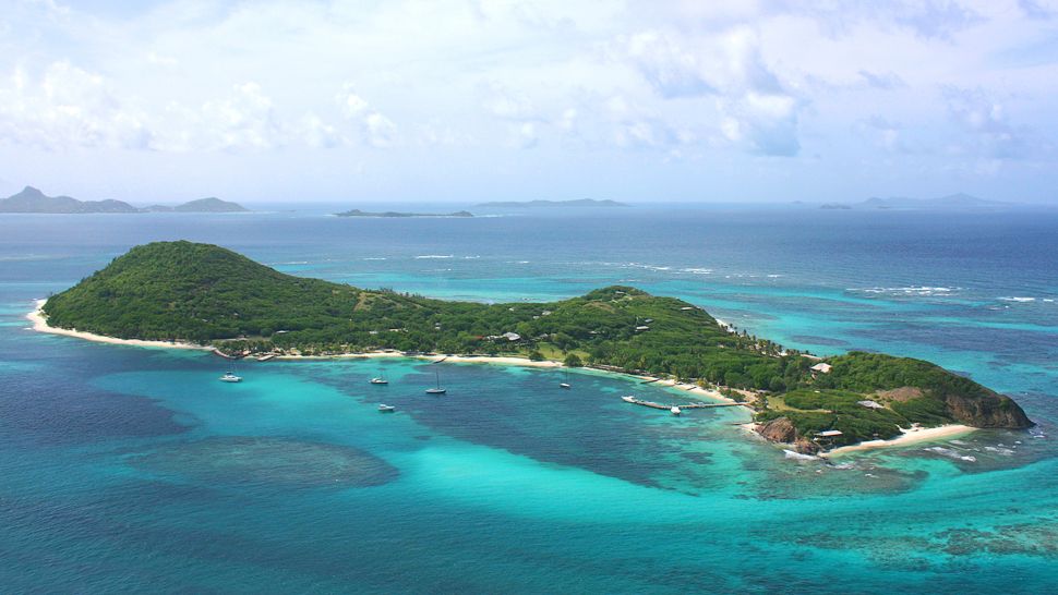
Now, considering all of our accumulated information and facts, we can look back at
Photo #1 and begin to get an idea of the distances we're actually looking over. We can also return to the paragraph of questions about our point A.
What we can rule out:• It’s highly unlikely that we’re on land. Looking at reliable photos and judging distances, we find we’re often looking over less surface area of the earth in a linear fashion than we think we are, and Barbados is 108 miles away. Take it off the table.
• Are we in the air? Judging from the angle we’re looking out over the water, it’s highly improbable we’re in an airplane or helicopter. Even so, we've considered distances over water from the air and discovered we're not looking as far as we often
feel like we are. This is unlikely an aerial photo
• Considering how far out to sea from Saint Lucia the photo is taken from, it’s not likely being taken from a sea kayak, which would be much, much
closer to the surface of the water.
What can we conclude with reasonable confidence:• We’re most likely
on the water.
• The photo is probably being taken from the deck of a boat somewhere between the size of a leisure boat and a military vessel; anything in between. A cruise ship seems most likely, but we can’t state that definitively (we don’t have enough information).
• We’re likely seeing the greater portion of Saint Lucia’s
24 mile length.
• We’re seeing a considerably small portion of another island; either Dominica or Saint Vincent.
Also notice that we're seeing a sail boat and possibly a motorboat. These leisure boats tell us we're probably not too incredibly far off the coast of Saint Vincent.
If you do thorough research, gather a body valid information and facts, make healthy comparisons, you can calibrate (or re-calibrate) your perception and perspective to get a more accurate overview and make a more accurate assessment of what you're considering. Accuracy is important.
This is just considering
Photo #1, although it gets easier from here because I've laid the groundwork. With careful planning, I've built a strong foundation, starting with the Danyang–Kunshan Grand Bridge and related bridges in China and America, the topography and geography of lakes and salt flats, the distances we're considering regarding looking over and across open water in photos (with bridges, shores, and islands; lakes and ocean). And the over-riding theme I'm developing is about correcting our incompetencies by calibrating our perceptions and perspective with readily available facts.