In proving whether or not the Earth is flat can't we just do a simple distance test, assuming that any direction towards the perimeter of the Antarctic Ice Wall is south?
...
What do you guys think about that? Is this a feasible idea?
You don't really need to go to all that trouble. Do this:
* Go to Google Maps.
* Type in "Santiago, Chile", hit enter.
* Click "Directions"
* Type in "Sydney, Australia", hit enter.
It tells you that Qantas airlines will fly you direct (4 flights per week) taking 12h 15min...and it draws you a map, showing you'd be flying West-to-East.
Now (just for grins) click the up/down arrow icon up where you entered your start and end point. Now it tells you that to get from Sandiago, back to Sydney takes 13hr 45 min...but the route is the same.
OK, so I could tell you how to get onto the Qantas site and confirm all of this - but I'm sure you can figure that out if you're mega-sceptical.
Now - go to a regular Google search window and type: "distance sydney to sandiago chile" (make sure it's "sandiago chile" and not "san diego"!) 11340 km.
So the plane is flying West/East at a speed of 11,340/12.25 = 925 kph...which is 575mph. On the East/West return trip, it's 824kph or 512mph. The difference is because the prevailing winds in the southern hemisphere blows west-to-east, so there is a tail-wind on the outbound leg and a head wind on the way back.
Phew. OK - so we can look up the data for a 747-400 (that's what Qantas fly on that route)...the Wikipedia page says with maximum payload it can fly 14,200km non-stop (so it can make the 11,340km trip with a healthy safety margin)...and it's cruise speed is 933kph...which is a little faster than we calculated - but commercial flight times are always padded by a little bit to allow for takeoff and landing times, etc.
This all seems very self-consistent doesn't it.
Trouble is, in the FE map - the distance from Sydney to Sandiago Chile is a lot more than that. FE map distances are the same as RE map distances on North/South routes - but differ wildly from RE distances on East/West routes - and increasingly so the further south you go.
So on both a round and a flat earth map, 11,300 km is about the distance from Johannesburg (South Africa) to Venice (italy).
Now...from the TFES.org Wiki (with some overlays of my own):
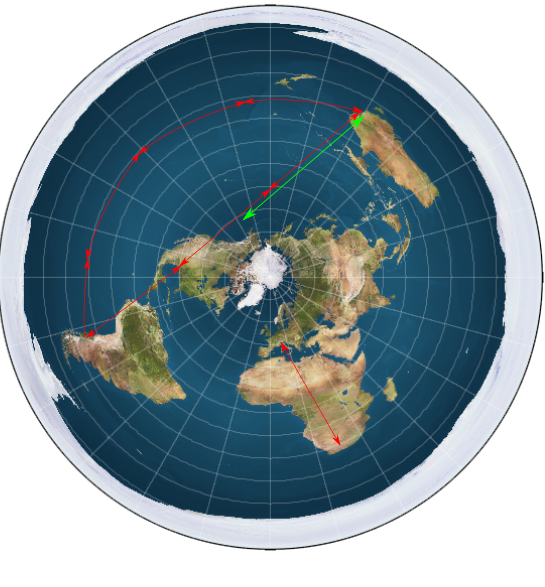
So - each red line (pretty much North/South from Venice to Johannesburg) must be about 11,000 km on both RE and FE maps.
The green line represents the 14,200km range of a 747-400 airplane.
It's rather clear that if the airplane takes the route that Google says it does - and how the flight would go if the pilot uses a compass or a GPS to follow what he believes to be the shortest RE distance, then on the FE map, the curved route is over three and a half times the distance he'd have to fly if the Earth is round.
Even if he takes a "short cut" over North America - he needs three times the distance.
Clearly he can't be taking that short cut because I'm quite sure people on the plane would look out of the window and notice that nearly half of the trip was over land...and every air traffic controller along the way would be surprised at a Qantas flight over their airspace at that time!
Qantas also fly non-stop to South Africa - and almost the exact same problem happens there.
So the FE map on the Wiki simply doesn't hold up to scrutiny...and you don't need to do the experiment you describe because Qantas airlines do eight flights (four each way) every week.
The ONLY semi-plausible answers from FE'ers on this is are:
1) That the jet stream speeds the aircraft up...but that's ridiculous because it can't possibly speed it up in BOTH directions.
2) That this map is only an approximation, and...meh. But there isn't a way to fix this...either this distance is wildly wrong - or some other distance is off by a similar amount.
3) There is a "new" map - which includes antarctica as a separate continent - basically, this one:
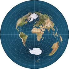
This actually makes the West-to-East route for Qantas even longer - and the short-cut takes them over antarctica...but Australians are going to have to learn all new geography.
So...yeah...a bit of googling around and the problem for the FE'ers is clear. How can you POSSIBLY explain your way out of this one?